
Baldwin, Maine facts for kids
Quick facts for kids
Baldwin, Maine
|
|
|---|---|

Pequawket Trail c. 1906
|
|

Location in Cumberland County and the state of Maine.
|
|

Baldwin, Maine
Location in Maine

Baldwin, Maine
Location in the United States

Baldwin, Maine
Location in North America
|
|
| Country | United States |
| State | Maine |
| County | Cumberland |
| Incorporated | 1802 |
| Named for | Loammi Baldwin |
| Villages | Cornish Station East Baldwin North Baldwin West Baldwin |
| Area | |
| • Total | 36.35 sq mi (94.15 km2) |
| • Land | 35.32 sq mi (91.48 km2) |
| • Water | 1.03 sq mi (2.67 km2) |
| Elevation | 679 ft (207 m) |
| Population
(2020)
|
|
| • Total | 1,520 |
| • Density | 43/sq mi (16.6/km2) |
| Time zone | UTC-5 (Eastern (EST)) |
| • Summer (DST) | UTC-4 (EDT) |
| ZIP Codes |
04024 (East Baldwin)
04091 (West Baldwin) |
| Area code(s) | 207 |
| FIPS code | 23-02655 |
| GNIS feature ID | 0582338 |
Baldwin is a small town located in Cumberland County, Maine, in the United States. In 2020, about 1,520 people lived there. It is part of the larger Portland area.
Contents
History of Baldwin
Baldwin was first known as Flintstown Plantation. It was given to soldiers from Concord, Massachusetts, in 1774. These soldiers were part of Captain John Flint's company. The land was a replacement for an earlier grant from around 1735. That first grant ended up being in New Hampshire after state borders changed.
On June 23, 1802, Flintstown officially became the town of Baldwin. It was named after Colonel Loammi Baldwin. The famous Baldwin apple is also named after him! Later, in 1826, the nearby town of Sebago was formed from part of Baldwin.
Early Industries and Farming
The land in Baldwin is hilly but good for farming. Farmers grew grain and hay. The town was especially known for its many orchards. There was even a factory in East Baldwin that dried apples. A corn factory also operated in the area.
Small streams and brooks provided water power for different mills. These mills helped produce lumber, barrel staves (pieces for barrels), and shooks (parts for barrels). The Saco River was also important. The Portland and Ogdensburg Railroad line followed the Saco River valley through Baldwin.
Geography and Location
Baldwin covers a total area of about 36.35 square miles (94.15 square kilometers). Most of this area, about 35.32 square miles (91.48 square kilometers), is land. The rest, about 1.03 square miles (2.67 square kilometers), is water. Breakneck Brook and the Saco River flow through the town.
Neighboring Towns and Roads
Baldwin is surrounded by several other towns. To the north is Sebago. To the east is Standish. On the west side is Hiram. To the south are Cornish and Limington.
Several state roads pass through Baldwin. These include Route 5, Route 107, Route 113, and Route 117.
Population Information
| Historical population | |||
|---|---|---|---|
| Census | Pop. | %± | |
| 1790 | 190 | — | |
| 1800 | 370 | 94.7% | |
| 1810 | 546 | 47.6% | |
| 1820 | 1,120 | 105.1% | |
| 1830 | 947 | −15.4% | |
| 1840 | 1,134 | 19.7% | |
| 1850 | 1,100 | −3.0% | |
| 1860 | 1,227 | 11.5% | |
| 1870 | 1,101 | −10.3% | |
| 1880 | 1,123 | 2.0% | |
| 1890 | 932 | −17.0% | |
| 1900 | 821 | −11.9% | |
| 1910 | 791 | −3.7% | |
| 1920 | 700 | −11.5% | |
| 1930 | 694 | −0.9% | |
| 1940 | 721 | 3.9% | |
| 1950 | 725 | 0.6% | |
| 1960 | 773 | 6.6% | |
| 1970 | 878 | 13.6% | |
| 1980 | 1,140 | 29.8% | |
| 1990 | 1,219 | 6.9% | |
| 2000 | 1,290 | 5.8% | |
| 2010 | 1,525 | 18.2% | |
| 2020 | 1,520 | −0.3% | |
| U.S. Decennial Census | |||
2010 Census Details
In 2010, there were 1,525 people living in Baldwin. There were 588 households, which are groups of people living together. About 31.6% of these households had children under 18 years old. The average age of people in Baldwin was 42.4 years.
Local Schools
Students in Baldwin attend these schools:
- Sacopee Valley Middle School
- Sacopee Valley High School
Notable People from Baldwin
Some well-known people have come from Baldwin:
- Isaac W. Dyer, a US District Attorney
- Josiah Pierce, who was the president of the Maine Senate
- Ledell Titcomb, a baseball player
- Andrew Clements, a famous author
Images for kids
-
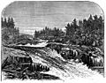
Great Falls in 1869
-
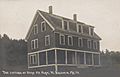
Dyke Mtn. Farm in 1919
-
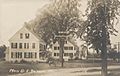
East Baldwin c. 1915


See also
 In Spanish: Baldwin (Maine) para niños
