
Bandera County, Texas facts for kids
Quick facts for kids
Bandera County
|
|||
|---|---|---|---|

The Bandera County Courthouse in Bandera. The building was added to the National Register of Historic Places on October 31, 1979.
|
|||
|
|||

Location within the U.S. state of Texas
|
|||
 Texas's location within the U.S. |
|||
| Country | |||
| State | |||
| Founded | 1856 | ||
| Named for | Bandera Pass | ||
| Seat | Bandera | ||
| Largest community | Lakehills | ||
| Area | |||
| • Total | 798 sq mi (2,070 km2) | ||
| • Land | 791 sq mi (2,050 km2) | ||
| • Water | 6.7 sq mi (17 km2) 0.8% | ||
| Population
(2020)
|
|||
| • Total | 20,851 | ||
| • Density | 26.129/sq mi (10.088/km2) | ||
| Time zone | UTC−6 (Central) | ||
| • Summer (DST) | UTC−5 (CDT) | ||
| Congressional district | 21st | ||


Bandera County is a county in the U.S. state of Texas. Its name comes from a Spanish word meaning "flag." It is located in a beautiful area called the Texas Hill Country. The main town and county seat is Bandera.
Many of the first settlers in Bandera County were from Germany and Poland in the mid-1800s. Today, many people living there are descendants of those early families.
In 2020, about 20,851 people lived in Bandera County. It is part of the larger San Antonio area. The state of Texas officially calls Bandera County the "Cowboy Capital of the World."
Contents
History
Early Days and Native Americans
People have lived in the Bandera County area for a very long time, possibly as far back as 8,000 to 4,000 BC. Later, Native American groups like the Lipan Apache and Comanche lived here in the 1600s.
In 1841, a group of Texas Rangers led by John Coffee Hays had a battle with Comanche warriors. This event, known as the Battle of Bandera Pass, helped make the area safer for new settlers.
Settlement and Growth
In 1853, John James and Charles S. DeMontel started planning the town of Bandera. Families like the Milsteads and Odems began to settle along the river, making cypress shingles. Soon, a sawmill and a store were built.
In 1855, 16 Polish families arrived in Bandera. They came after their home country faced many problems. These families started working in the sawmill. In 1856, the Texas Legislature officially created Bandera County. It was formed from parts of Bexar and Uvalde Counties. The county and its main town were named after Bandera Pass.
By 1860, the county's population grew to 399 people. Later in the 1800s, raising sheep and Angora goats became more important than farming for many people.
20th Century and Tourism
In 1920, Cora and Ed Buck started the county's tourism industry. They welcomed guests to their ranch. By 1933, the Frontier Times Museum opened, showing off the area's history.
To protect its beautiful nature, Bandera County took important steps in the late 1900s.
- The Lost Maples State Natural Area opened in 1979.
- The Hill Country State Natural Area opened in 1984.
- In 2000, the Nature Conservancy bought land to create the Love Creek Preserve. These efforts help keep the county's natural beauty safe for everyone to enjoy.
Geography
Bandera County covers about 798 square miles. Most of this (791 square miles) is land, and a small part (6.7 square miles) is water. The county is part of the larger San Antonio area. It sits on a high area of land called the Edwards Plateau.
Main Roads
 State Highway 16
 State Highway 46
 State Highway 173
 Park Road 37
 Ranch to Market Road 187
 Ranch to Market Road 337
 Ranch to Market Road 1077
 Farm to Market Road 1283
 Ranch to Market Road 2828
 Farm to Market Road 3240
Neighboring Counties
Bandera County shares borders with these other counties:
- Kerr County (north)
- Kendall County (northeast)
- Bexar County (southeast)
- Medina County (south)
- Uvalde County (southwest)
- Real County (west)
People and Population
| Historical population | |||
|---|---|---|---|
| Census | Pop. | %± | |
| 1860 | 399 | — | |
| 1870 | 649 | 62.7% | |
| 1880 | 2,158 | 232.5% | |
| 1890 | 3,795 | 75.9% | |
| 1900 | 5,332 | 40.5% | |
| 1910 | 4,921 | −7.7% | |
| 1920 | 4,001 | −18.7% | |
| 1930 | 3,784 | −5.4% | |
| 1940 | 4,234 | 11.9% | |
| 1950 | 4,410 | 4.2% | |
| 1960 | 3,892 | −11.7% | |
| 1970 | 4,747 | 22.0% | |
| 1980 | 7,084 | 49.2% | |
| 1990 | 10,562 | 49.1% | |
| 2000 | 17,645 | 67.1% | |
| 2010 | 20,485 | 16.1% | |
| 2020 | 20,851 | 1.8% | |
| U.S. Decennial Census 1850–2010 2010 2020 |
|||
In 2020, Bandera County had 20,851 residents. Most people living in the county are White (about 74.8%). About 19.2% of the population is Hispanic or Latino.
In 2010, about 92.8% of people were White, 0.8% Native American, and 0.5% Black or African American. About 16.7% of the population was Hispanic or Latino.
In 2000, there were 17,645 people living in the county. The average age was 41 years old. About 24.7% of the people were under 18. The median income for a family was about $45,906.
Education
Several school districts serve the students of Bandera County:
- Bandera Independent School District
- Medina Independent School District (part of it)
- Northside Independent School District (part of it)
- Utopia Independent School District (part of it)
All of Bandera County is also served by the Alamo Community College District. This means students can attend community college classes there.
Communities
City
- Bandera (This is the county seat, where the main government offices are.)
Towns and Places
- Lake Medina Shores (partly in Medina County)
- Lakehills (This is the largest community in the county.)
Other Communities
Old Town
- Tuff (This is a "ghost town," meaning it's no longer inhabited.)
Images for kids
-
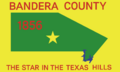
The flag of Bandera County.
-

The seal of Bandera County.
-
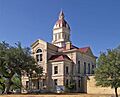
The Bandera County Courthouse in Bandera.
See also
 In Spanish: Condado de Bandera para niños
