Bannock County, Idaho facts for kids
Quick facts for kids
Bannock County
|
||
|---|---|---|

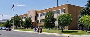
Bannock County Courthouse in Pocatello
|
||
|
||

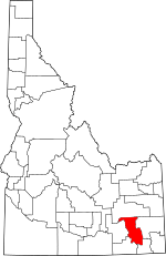
Location within the U.S. state of Idaho
|
||
 Idaho's location within the U.S. |
||
| Country | ||
| State | ||
| Founded | March 6, 1893 | |
| Named for | Bannock tribe | |
| Seat | Pocatello | |
| Largest city | Pocatello | |
| Area | ||
| • Total | 1,147 sq mi (2,970 km2) | |
| • Land | 1,112 sq mi (2,880 km2) | |
| • Water | 35 sq mi (90 km2) 3.1% | |
| Population
(2020)
|
||
| • Total | 87,018 | |
| • Estimate
(2023)
|
90,400 |
|
| • Density | 76/sq mi (29/km2) | |
| Time zone | UTC−7 (Mountain) | |
| • Summer (DST) | UTC−6 (MDT) | |
| Congressional district | 2nd | |
Bannock County is a county located in the southeastern part of Idaho. It's a place where many people live and work.
As of the 2020 census, about 87,018 people called Bannock County home. This makes it the sixth-most populated county in Idaho. The main city and county seat is Pocatello. This is where the county government offices are located.
Bannock County was officially created in 1893. It was named after the local Bannock tribe. Some parts of the Fort Hall Indian Reservation are also found within Bannock County. This reservation belongs to the Shoshone-Bannock Tribes.
Contents
Exploring Bannock County's Geography
Bannock County covers a total area of about 1,147 square miles. Most of this area, about 1,112 square miles, is land. The remaining 35 square miles, or 3.1%, is water.
The Portneuf River flows through the county. It eventually joins the Snake River at the county's lowest point. This meeting happens at the American Falls Reservoir.
The highest point in the county is Bonneville Peak. It stands tall at 9,271 feet (2,826 meters) above sea level. This peak is on the eastern border, in the Portneuf Range. On its western side, you can find the Pebble Creek ski area, which is a fun place for winter sports.
Neighboring Counties
Bannock County shares its borders with several other counties.
- Bingham County - to the north
- Caribou County - to the east
- Franklin County - to the southeast
- Oneida County - to the southwest
- Power County - to the west
Major Roads and Highways
Several important roads pass through Bannock County. These highways help people travel around the county and to other parts of Idaho.
 - Interstate 15
 - Interstate 86
 - US 30
 - US 91
 - SH-40
Protected Natural Areas
A part of the Caribou National Forest is located within Bannock County. These protected areas help keep nature safe and offer places for outdoor activities.
Who Lives in Bannock County?
The population of Bannock County has grown over the years.
| Historical population | |||
|---|---|---|---|
| Census | Pop. | %± | |
| 1900 | 11,702 | — | |
| 1910 | 19,242 | 64.4% | |
| 1920 | 27,532 | 43.1% | |
| 1930 | 31,266 | 13.6% | |
| 1940 | 34,759 | 11.2% | |
| 1950 | 41,745 | 20.1% | |
| 1960 | 49,342 | 18.2% | |
| 1970 | 52,200 | 5.8% | |
| 1980 | 65,421 | 25.3% | |
| 1990 | 66,026 | 0.9% | |
| 2000 | 75,565 | 14.4% | |
| 2010 | 82,839 | 9.6% | |
| 2020 | 87,018 | 5.0% | |
| 2023 (est.) | 90,400 | 9.1% | |
| U.S. Decennial Census 1790–1960, 1900–1990, 1990–2000, 2010–2020 |
|||
Bannock County is part of the Pocatello Metropolitan Statistical Area. This means it's part of a larger urban area centered around Pocatello.
Population Details from 2010
In 2010, there were 82,839 people living in Bannock County. These people lived in 30,682 households, with 20,836 of them being families. On average, there were about 74 people per square mile.
Most people in the county were white (89.8%). Other groups included American Indian (3.2%), Asian (1.3%), and Black or African American (0.8%). People from other backgrounds also lived there. About 6.7% of the population was of Hispanic or Latino origin.
The average age of people in the county was 31.4 years old. Many households (35.5%) had children under 18 living with them. About 52.2% of households were married couples.
The average income for a household in the county was around $44,848 per year. For families, the average income was about $54,650.
Towns and Cities in Bannock County
Bannock County is home to several communities, from small towns to larger cities.
Cities
Special Census Areas
These are areas that are like towns but are not officially incorporated as cities.
Other Communities
These are smaller places that are not officially organized as cities or census-designated places.
- Blackrock
- Portneuf
- Robin
- Swanlake
- Virginia
- Zenda
Learning in Bannock County
Bannock County has several school districts that serve its students.
- Grace Joint School District 148
- Marsh Valley Joint School District 21
- Pocatello/Chubbuck School District 25
- Preston Joint School District 201
- West Side Joint School District 202
There is also a special school called Shoshone Bannock Jr./Sr. High School. This school is connected with the Bureau of Indian Education (BIE).
See also
 In Spanish: Condado de Bannock para niños


