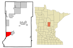
Baxter, Minnesota facts for kids
Quick facts for kids
Baxter
|
|
|---|---|
| Motto(s):
A Growing Community
|
|

|
|
| Country | United States |
| State | Minnesota |
| County | Crow Wing |
| Incorporated | May 25, 1939 |
| Area | |
| • Total | 21.11 sq mi (54.67 km2) |
| • Land | 18.85 sq mi (48.83 km2) |
| • Water | 2.25 sq mi (5.84 km2) |
| Elevation | 1,194 ft (364 m) |
| Population
(2020)
|
|
| • Total | 8,612 |
| • Estimate
(2022)
|
8,971 |
| • Density | 456.82/sq mi (176.38/km2) |
| Time zone | UTC-6 (Central) |
| • Summer (DST) | UTC-5 (CDT) |
| ZIP codes |
56401, 56425
|
| Area code(s) | 218 |
| FIPS code | 27-04042 |
| GNIS feature ID | 2394086 |
Baxter is a city in Crow Wing County, Minnesota, United States. It is a growing community known for its many lakes and natural beauty. About 8,600 people lived here in 2020. Baxter is part of the larger Brainerd area.
Two important roads, Minnesota State Highways 210 and 371, run through the city.
Contents
Exploring Baxter's Location
Baxter is located just north of the very center of Minnesota. This area was shaped by huge sheets of ice, called glaciers, long ago. Because of this, Baxter has many beautiful lakes and ponds.
The city shares its western border with Cass County. To the east, it borders the city of Brainerd. The famous Mississippi River forms Baxter's southern edge.
Baxter is part of a popular vacation spot called the Brainerd Lakes Area. This region includes Crow Wing County and parts of nearby counties.
The city covers about 20.62 square miles (53.4 square kilometers). Most of this area is land, with about 2.23 square miles (5.8 square kilometers) being water.
A Look at Baxter's History
Baxter became a city partly because of a large plant that treated railroad ties. This plant was owned by the Northern Pacific Railroad and operated in the 1920s. Farming was also an important activity in the early days.
Baxter officially became a city on May 25, 1939. The city was named after Luther Baxter. He was a lawyer for the railroad and also served in the Minnesota government. He was even a colonel during the Civil War.
Today, Tourism is a very important industry in Baxter. Many people visit the area for its lakes and outdoor activities. Other service businesses also provide many jobs. New neighborhoods have been built in the wooded areas, and more shops and businesses have opened along Highway 371.
People of Baxter
The city of Baxter has grown quite a bit over the years. Here's how the population has changed:
| Historical population | |||
|---|---|---|---|
| Census | Pop. | %± | |
| 1930 | 169 | — | |
| 1940 | 357 | 111.2% | |
| 1950 | 507 | 42.0% | |
| 1960 | 1,037 | 104.5% | |
| 1970 | 1,556 | 50.0% | |
| 1980 | 2,625 | 68.7% | |
| 1990 | 3,695 | 40.8% | |
| 2000 | 5,555 | 50.3% | |
| 2010 | 7,610 | 37.0% | |
| 2020 | 8,612 | 13.2% | |
| 2022 (est.) | 8,971 | 17.9% | |
| U.S. Decennial Census 2020 Census |
|||
Baxter's Population in 2010
In 2010, there were 7,610 people living in Baxter. These people lived in 2,963 households, with 2,110 of them being families. On average, there were about 414 people per square mile.
Most of the people in Baxter were White (96.5%). There were also smaller groups of African American, Native American, and Asian residents. About 1.1% of the population was Hispanic or Latino.
About 35.8% of households had children under 18 living with them. Most households (59.5%) were married couples. The average household had 2.55 people, and the average family had 3.02 people.
The median age in Baxter was 38.7 years. About 27% of residents were under 18. About 15.8% were 65 years old or older. Slightly more than half of the population (51.7%) was female.
Education in Baxter
Students living in Baxter attend schools that are part of the Brainerd Public Schools district. The main high school for students in Baxter is Brainerd High School.
See also
 In Spanish: Baxter (Minnesota) para niños
 | DeHart Hubbard |
 | Wilma Rudolph |
 | Jesse Owens |
 | Jackie Joyner-Kersee |
 | Major Taylor |

