Bedford, New Hampshire facts for kids
Quick facts for kids
Bedford, New Hampshire
|
||
|---|---|---|
|
Town
|
||

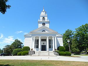
Bedford Presbyterian Church
|
||
|
||

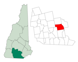
Location in Hillsborough County, New Hampshire
|
||
| Country | United States | |
| State | New Hampshire | |
| County | Hillsborough | |
| Incorporated | 1750 | |
| Named for | John Russell, 4th Duke of Bedford | |
| Area | ||
| • Total | 33.1 sq mi (85.6 km2) | |
| • Land | 32.8 sq mi (84.9 km2) | |
| • Water | 0.3 sq mi (0.7 km2) 0.85% | |
| Elevation | 308 ft (94 m) | |
| Population
(2020)
|
||
| • Total | 23,322 | |
| • Density | 711/sq mi (274.7/km2) | |
| Time zone | UTC−5 (Eastern) | |
| • Summer (DST) | UTC−4 (Eastern) | |
| ZIP code |
03110
|
|
| Area code | 603 | |
| FIPS code | 33-011-04500 | |
| GNIS feature ID | 0873541 | |
Bedford is a town in Hillsborough County, New Hampshire, United States. It's a growing community and a suburb of Manchester, which is New Hampshire's largest city. In 2020, about 23,322 people lived in Bedford. This number shows that the town has grown quite a bit over the years!
Contents
Bedford's Story: A Look at Its History
How Bedford Got Started
Bedford was first created in 1733 by the Province of Massachusetts Bay. It was known as "Narragansett, No. 5" and was set aside for soldiers. These soldiers had fought in a conflict against the Narragansett people in Rhode Island. The area was also called "Souhegan East."
In 1750, the settlement officially became a town and was named "Bedford." It was named after John Russell, 4th Duke of Bedford. He was a close friend of the governor at the time, Benning Wentworth.
Early Settlers and Growth
The first English settlers in Bedford were Robert and James Walker III. You can still find a monument from 1737 on Station Road that marks where the first settlement was. The town's first leader, called a "moderator," was Mayor John Goffe. His father, Colonel John Goffe, is the person Goffstown was named after.
In the late 1800s, trains started serving Bedford. This helped the town connect with other places.
Bedford's Recent Growth
Bedford has grown very quickly, especially in the last half of the 1900s. For example, in 1950, only about 2,176 people lived there. By 2000, that number had jumped to over 18,000! This fast growth continued, and by 2020, Bedford became the 11th largest town in New Hampshire.
Exploring Bedford's Geography
Bedford covers an area of about 85.6 square kilometers (about 33 square miles). Most of this area is land, with a small part being water. The largest body of water is Sebbins Pond. It connects to smaller ponds through Sebbins Brook. The famous Merrimack River also flows nearby.
Cool Natural Features
One interesting natural spot in Bedford is a rock formation called Pulpit Rock. It's part of the town's Pulpit Rock Conservation Area. The highest point in Bedford is Holbrook Hill, which is about 845 feet (258 meters) above sea level. All the water in Bedford eventually flows into the Merrimack River.
Neighboring Towns
Bedford shares its borders with several other towns:
- Goffstown to the north
- Manchester to the east
- Merrimack to the south
- Amherst to the southwest
- New Boston to the west
Getting Around Bedford: Transportation
Bedford has two main highways that help people travel easily. The Everett Turnpike runs north and south, and Route 101 runs east and west. These highways connect to Interstate 293, making it simple to reach other areas. US 3 also passes through the town.
If you need to fly, the Manchester–Boston Regional Airport is very close by, just one town away in Manchester.
There are also plans to extend the MBTA Commuter Rail's Lowell Line to Manchester. This would include a stop in Bedford, which would be great for both the town and the airport!
Who Lives in Bedford: Demographics
| Historical population | |||
|---|---|---|---|
| Census | Pop. | %± | |
| 1790 | 898 | — | |
| 1800 | 1,182 | 31.6% | |
| 1810 | 1,296 | 9.6% | |
| 1820 | 1,375 | 6.1% | |
| 1830 | 1,554 | 13.0% | |
| 1840 | 1,549 | −0.3% | |
| 1850 | 1,914 | 23.6% | |
| 1860 | 1,172 | −38.8% | |
| 1870 | 1,221 | 4.2% | |
| 1880 | 1,204 | −1.4% | |
| 1890 | 1,102 | −8.5% | |
| 1900 | 1,148 | 4.2% | |
| 1910 | 1,110 | −3.3% | |
| 1920 | 1,118 | 0.7% | |
| 1930 | 1,326 | 18.6% | |
| 1940 | 1,561 | 17.7% | |
| 1950 | 2,176 | 39.4% | |
| 1960 | 3,636 | 67.1% | |
| 1970 | 5,859 | 61.1% | |
| 1980 | 9,481 | 61.8% | |
| 1990 | 12,563 | 32.5% | |
| 2000 | 18,274 | 45.5% | |
| 2010 | 21,203 | 16.0% | |
| 2020 | 23,322 | 10.0% | |
| U.S. Decennial Census | |||
| Race | Percentage |
|---|---|
| White, not Hispanic or Latino | 86% |
| Asian | 7% |
| Hispanic or Latino | 3% |
| Black or African American | 2% |
In 2020, Bedford had a population of 23,322 people. Most residents were White (86.1%), with smaller percentages of Asian (7.2%), African American (1.5%), and other groups. About 3.2% of the population was Hispanic or Latino.
Many households in Bedford have families. In 2010, about 40.9% of households had children under 18 living there. The average household had about 2.81 people. The median age in Bedford was 42.3 years old.
Bedford is known for having a good economy. Between 2006 and 2010, the average household income was quite high, making Bedford one of the wealthiest towns in New Hampshire.
Learning in Bedford: Education
Bedford has a great school system with six schools.
- Elementary Schools: Memorial Elementary School, Peter Woodbury Elementary School, and Riddle Brook Elementary School teach students from kindergarten to 4th grade. Riddle Brook has even won the National Blue Ribbon School award multiple times!
- Intermediate School: McKelvie Intermediate School is for 5th and 6th graders.
- Middle and High Schools: Ross A. Lurgio Middle School (grades 7-8) and Bedford High School (grades 9-12) opened in 2007. These two schools share a large building, which helps them save money by sharing things like the kitchen and auditorium. However, they operate as separate schools with different entrances and schedules.
A part of Saint Anselm College, a higher education institution, is also located in Bedford, including some of its sports fields.
Before 2007, high school students from Bedford used to go to Manchester West High School. But now, all high school students attend Bedford High School.
Famous People from Bedford
- Silas Aiken (1799–1869), minister and author
- David Atwood (1815–1889), newspaperman and U.S. congressman; born in Bedford
- Chris Carpenter (born 1975), baseball pitcher for the St. Louis Cardinals
- Zachariah Chandler (1813–1879), U.S. Secretary of the Interior and U.S. senator; born in Bedford
- John Goffe (1701–1786), colonial soldier
- Carrie Jones (born 1982), bestselling author of young adult novels; born in Bedford
- Dean Kamen (born 1951), inventor of the Segway HT and the iBOT
- Grant Lavigne (born 1999), minor-league baseball player
- Josh Meyers (born 1976), actor and comedian
- Seth Meyers (born 1973), comedian and talk-show host (Saturday Night Live, Late Night with Seth Meyers)
- Mace Moulton (1796–1867), U.S. congressman
- Rand Pecknold (born 1967), college ice hockey coach
- Patricia Racette (born 1965), opera singer
- Laura Silverman (born 1966), actress
- Sarah Silverman (born 1970), comedian, voice actress, and writer
- Alex Steeves (born 1999), hockey player for the Toronto Maple Leafs
- John E. Sununu (born 1964), former U.S. senator
- Peter Woodbury (1899–1970), judge
Images for kids
See also
 In Spanish: Bedford (Nuevo Hampshire) para niños
 | Stephanie Wilson |
 | Charles Bolden |
 | Ronald McNair |
 | Frederick D. Gregory |


