Beinn Achaladair facts for kids
Quick facts for kids Beinn Achaladair |
|
|---|---|

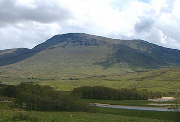
Beinn Achaladair seen from the north west near Loch Tulla.
|
|
| Highest point | |
| Elevation | 1,038 m (3,406 ft) |
| Prominence | 225 m (738 ft) |
| Parent peak | Beinn a' Chreachain |
| Listing | Munro, Marilyn |
| Naming | |
| English translation | Hill of the Field of Hard Water or Hill of the Mower |
| Language of name | Gaelic |
| Geography | |
|
Lua error in Module:Location_map at line 420: attempt to index field 'wikibase' (a nil value).
|
|
| Parent range | Bridge of Orchy Hills, Grampians |
| OS grid | NN344432 |
| Topo map | OS Landranger 50, OS Explorer 377 |
| Climbing | |
| Easiest route | By Coire Achaladair |
| Listed summits of Beinn Achaladair | ||||
| Name | Grid ref | Height | Status | |
|---|---|---|---|---|
| South Top | NN343420 | 1002 m (3287 ft) | Munro Top | |
Beinn Achaladair is a cool Scottish mountain. It's about six kilometers (around 3.7 miles) northeast of a small place called Bridge of Orchy. This mountain sits right on the edge of two areas: Perth and Kinross and Argyll and Bute.
Contents
What is Beinn Achaladair?
Beinn Achaladair is easy to spot for people traveling by road or train. The A82 road and the West Highland Line railway pass close to its base. The railway even goes along the lower northern parts of the mountain. It then crosses Rannoch Moor on its way to Fort William.
The Great Wall of Rannoch
From the northwest, Beinn Achaladair looks very grand. It has steep, wall-like slopes. It's part of a group of four mountains. These mountains include Beinn Dorain, Beinn an Dothaidh, and Beinn a' Chreachain. Together, they formed the "Great Wall of Rannoch." This wall was a historic border. It separated the old Pictish Kingdom in the east from the Dál Riata kingdom of the Scots in the west.
Mountain Facts: Height and Type
Beinn Achaladair is 1038 meters (about 3,406 feet) tall. It's known as a Munro. A Munro is a Scottish mountain over 3,000 feet (914.4 meters) high. It's also a Marilyn, which is a hill with a drop of at least 150 meters (492 feet) on all sides.
What Does the Name Mean?
This mountain is in the southern highlands of Scotland. It has rocky features like mountains further north. Its name likely comes from the nearby Achallader farm. In Gaelic, "Achaladair" means "Field of hard water." This refers to the area around Loch Tulla. This area used to flood and freeze often. Achallader farm was once the site of Achallader Castle. This was one of the strongholds of the Campbell clan. You can still see parts of the castle ruins today. Some people also say the name means "Hill of the Mower."
Exploring Beinn Achaladair's Features
Beinn Achaladair has a curved top ridge. This ridge is almost two kilometers (about 1.2 miles) long. It runs from north to south. The very highest point is at the northern end. From here, you can look out over Rannoch Moor. There are two small piles of stones, called cairns, near the top. The one further north is the highest point.
The South Top
Just over a kilometer (about 0.6 miles) south of the highest point is the South Top. This part of the mountain is 1002 meters (3,287 feet) high. It's listed as a "Top" in the Munro's Tables.
Corries and Waterways
Beinn Achaladair has two large, bowl-shaped hollows called corries. To the east of the top ridge is Coire nan Clach. This corrie has eight tiny lochs (small lakes) high up. Water from this corrie flows down Gleann Cailliche. This glen means "Glen of the Old Woman." It used to have many people living there. But they moved away during the Highland Clearances. The remains of old homes can still be seen. All the water from this side of the mountain eventually reaches the Firth of Tay on the east coast. It flows through Loch Lyon, Loch Tay, and the River Tay.
The other main corrie is Corrie Achaladair. It's on the south side of the mountain. It forms a low point, or col, with the nearby Munro of Beinn an Dotaidh. The northern and western slopes of Beinn Achaladair are steep and rocky higher up. Lower down, they become grassy. Many small streams flow down these grassy slopes. They drain into the Water of Tulla, which then flows into Loch Tulla.
How to Climb Beinn Achaladair
The most common way to climb Beinn Achaladair starts from Achallader farm. You can find it at grid reference NN322442. People often climb Beinn Achaladair along with Beinn a' Chreachain. Beinn a' Chreachain is about three kilometers (1.8 miles) northeast.
Starting the Climb
The farmer at Achallader is kind enough to let hikers park in a field. You can show your thanks by leaving money in an honesty box. From the farm, you climb up Coire Achaladair. You will pass several beautiful waterfalls on your way to the col (low point) with Beinn an Dotaidh.
Reaching the Summit
From the col, it's about a three-kilometer (1.8-mile) walk north to the summit. You'll climb over 300 meters (984 feet) higher. You'll also pass over the South Top on your way. The view from the top is amazing! You get a great view of Rannoch Moor. The flat moorland below makes you feel even higher up.
 | Delilah Pierce |
 | Gordon Parks |
 | Augusta Savage |
 | Charles Ethan Porter |

