
Beinn Odhar facts for kids
Quick facts for kids Beinn Odhar |
|
|---|---|

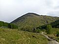
Beinn Odhar seen from the West Highland Way as it leaves Tyndrum.
|
|
| Highest point | |
| Elevation | 901 m (2,956 ft) |
| Prominence | 457 m (1,499 ft) |
| Listing | Corbett, Marilyn |
| Naming | |
| English translation | Dun Coloured Mountain |
| Language of name | Gaelic |
| Geography | |
| Location | Argyll and Bute/Stirling, Scotland |
| Parent range | Grampians |
| OS grid | NN337339 |
| Topo map | OS Landranger 50, OS Explorer 377 |


Beinn Odhar is a Scottish mountain. It stands at the northern end of the Loch Lomond and The Trossachs National Park.
The mountain is about 4 km (2.5 miles) north of Tyndrum village. You can see it clearly from there. Beinn Odhar sits on the border between the Argyll and Bute and Stirling council areas.
Contents
About Beinn Odhar
Beinn Odhar is 901 metres (2,956 feet) tall. This makes it a Corbett. A Corbett is a Scottish mountain between 762 and 914 metres high. It just misses being a Munro (a mountain over 914 metres) by 13 metres.
The hill is also a Marilyn. This means it stands out a lot from the land around it. Its "prominence" is 457 metres, making it a great spot for views.
Beinn Odhar has a steep, cone-like shape. It's covered in grass and is a familiar sight. People traveling on the A82 road and walkers on the West Highland Way pass right by it. Beinn Odhar looks a bit like Beinn Dorain, another mountain 4 km to its north.
What's in a Name?
The name Beinn Odhar comes from the Gaelic language. It means "Dun coloured mountain". "Dun" means a brownish-grey colour. This describes the colour of the heather and grass on the hill.
Beinn Odhar is part of a group called the "Auch Corbetts". These are five Corbetts that can be climbed in one long walk. This is quite rare for Corbetts. You can start this walk from the small village of Auch.
Mountain Features
Beinn Odhar has steep slopes on all sides. A long ridge goes southeast from the top for about 2.5 km. It then reaches a smaller peak called Meall Buidhe (653 metres).
On the eastern side, there's a deep cut made by a stream. This stream, called Allt Choire Dhuibh, starts from a small lochan (small lake). This lochan is called Lochan Choire Dhuibh and is almost 800 metres high. There's another unnamed lochan on the southern side.
The streams on the southern slopes form deep ravines. These flow into a corrie (a bowl-shaped hollow) called Coire Thoin. They are the start of the River Fillan.
Lead Mining History
On the northern slopes, there's another corrie called Coire Luaidh. This means "Corrie of Lead". This name comes from lead mining that happened here. People mined lead in the 1700s and 1800s.
Beinn Odhar is on the Tyndrum fault line. This area was known for its lead veins. While other mines nearby were very successful, the mines on Beinn Odhar were not as productive. You can still see signs of old mining on the southern slopes. At 650 metres high, there's an old adit (a tunnel into a mine) and lots of mining waste.
The mountain also sits on Scotland's drainage divide. This means rain falling on Beinn Odhar flows in two directions. Some water goes west towards Oban and the sea. Other water flows east into the River Tay and then to Dundee and the sea.
Climbing Beinn Odhar
Most people climb Beinn Odhar from the south. There are three main starting points.
One way is from Tyndrum village. You walk north on a track that used to be the main road. This track is now part of the West Highland Way. After 2 km, you leave the track and climb the southern slopes. You will pass the old mine and the unnamed lochan on this route.
Another starting point is Dalrigh on the A82 road. This route goes up the long south ridge. It passes over Meall Buidhe. This way is longer but not as steep.
For those who want to climb all five Auch Corbetts, it's a very tough day. It involves climbing over 2,000 metres in total. Guide books suggest starting from a parking spot on the A82. From here, you can climb Beinn Odhar by its south ridge.
At the top of Beinn Odhar, there is a stone cairn. From the summit, you get great views. You can see the Black Mount to the north. You can also see the hills around Crianlarich to the south.
Images for kids
-
Beinn Odhar seen from the West Highland Way as it leaves Tyndrum.
