
Bents Basin State Conservation Area facts for kids
Quick facts for kids Bents Basin State Conservation AreaNew South Wales |
|
|---|---|
|
IUCN Category II (National Park)
|
|

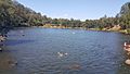
The basin, which is also a swimming area.
|
|

Bents Basin State Conservation Area
Location in New South Wales
|
|
| Nearest town or city | Silverdale Wallacia |
| Established | 11 September 1980 |
| Area | 0.62 km2 (0.2 sq mi) |
| LGA(s) | Liverpool City Council and Wollondilly Shire |
| Region | South-western Sydney |
| Visitation | (in 200,000) |
| Managing authorities | NSW National Parks and Wildlife Service |
| Website | Bents Basin State Conservation Area |
| See also | Protected areas of New South Wales |
Bents Basin is a special protected nature reserve and state park located near Wallacia, New South Wales, Australia. It's part of the wider Sydney area. This beautiful spot has a natural swimming hole, or basin, which was formed where the Nepean River flows out of a sandstone gorge. It's a very popular place for swimming and camping.
Bents Basin also has an education centre used by local schools. With its large woodland areas and native animals, it's the only picnic spot along the Nepean River. It's one of the most loved water-based parks in Greater Western Sydney.
Contents
Discovering Bents Basin's Past
Early Aboriginal History
Aboriginal people lived in the Bents Basin area for a very long time. The nearby Nepean River provided them with important food and water. It's believed that the Basin was a traditional meeting and trading place for different Aboriginal groups. This area was very important for their spiritual and cultural connections. They used camps here to stay connected with each other and their traditions.
European Discovery and Development
A botanist named George Caley discovered Bents Basin in 1804. He first called it 'Dovedale'. Since then, it has been a popular place for scientists who study plants. The Basin was originally a small natural pool formed by erosion in the sandstone. In 1987–88, the Army's 17th Construction Squadron built a large earth dam, which made the basin much bigger.
An important old inn used to be located within the park. It was built in the 1860s and is listed on the NSW State Heritage Inventory. This inn tells us about the history of western Sydney, early roads, and how rural communities grew and changed. The inn was destroyed in the 1950s, but you can still find its location marked by a pepper tree. Bents Basin officially became a State Recreation Area in 1994.
Exploring Bents Basin's Geography
Landscape and Waterways
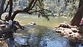
Bents Basin features a flat floodplain and sits on a higher plateau. The basin itself is a round, lagoon-like pool. It is about 120 metres (390 feet) across and more than 22 metres (72 feet) deep. The water from the basin travels about 150 kilometres (93 miles) northeast through the Hawkesbury River before reaching the ocean near the Central Coast.
Bents Basin is located about 36 kilometres (22 miles) south of Penrith. It is also about 56 kilometres (35 miles) south-west of the Sydney central business district. To the east of the basin, there is an open, gently rolling field on the clay soils of the Cumberland Plain.
Nearby Areas and Flood Risks
The Basin is next to the Gulguer Nature Reserve to the south. There are also two small creeks in the area. Large parts of the reserve can flood easily. When floods happen, the basin is often completely or partly closed for water activities because it becomes too dangerous.
Amazing Wildlife at Bents Basin
Animals You Might See
Bents Basin is home to many different animal species. You might spot the Common bent-wing bat, the sooty owl, and the Common wombat. Other bats like the East-coast free-tailed bat and the large-eared pied bat also live here. Keep an eye out for the powerful owl and the beautiful glossy black cockatoo.
Diverse Plant Life
The basin has an incredible variety of plants, with 25 different plant communities and about 360 plant species. Two rare tree species found in the park are the Hibbertia hermanniifolia and the Eucalyptus benthamii.
Other plant species you can find include:
- Angophora subvelutina
- Eucalyptus pilularis
- Eucalyptus eugenioides
- Acacia parramattensis
- Backhousia myrtifolia
- Pratia purpurascens
- Asplenium flabellifolium
- Adiantum aethiopicum
- Oplismenus imbecillis
- Cynodon dactylon
- Tristaniopsis laurina
- Casuarina cunninghamiana
- Microlaena stipoides
- Syncarpia glomulifera
- Glochidion ferdinandi
- Ceratopetalum apetalum
Fun Things to Do at Bents Basin
Activities and Facilities
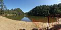
Bents Basin is a popular place for many outdoor activities. You can go swimming, kayaking, or enjoy a bushwalk. It's also great for camping, with 100 tent sites available. Many people come here for barbecues, picnics, and fishing.
The park has walking trails through the bushland. There's also an education centre with a kitchen, which can be rented for events. The Caley's Lookout Track is a walking path that leads to Little Mountain. This scenic lookout is 160 metres (520 feet) high and offers amazing views. You can also hire designated facilities for your own use.
Accessing the Park
There are two roads that lead to the park: Bents Basin Road in the northwest and Bents Loop Road in the park's east. However, only the eastern road (Bents Loop Road) allows you to reach the camping grounds and the education centre. There is a fee charged per day for vehicle access to the park.
Gallery
-
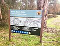
Entrance sign
-
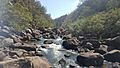
The rocky rapids of Nepean River flowing into the Basin (south side)
-
Nepean River streaming out of the Basin, going northwards (east side)
-
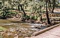
The boardwalk with basin in background
-
View from Nepean River's rocky bed, which produces northerly currents (south side)
-
The swimming hole after a flood
-
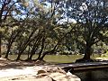
Looking from Nepean River boardwalk (east side)


