
Big Devil Peak facts for kids
Quick facts for kids Big Devil Peak |
|
|---|---|

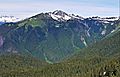
Big Devil Peak from the northeast
|
|
| Highest point | |
| Elevation | 7,055 ft (2,150 m) |
| Prominence | 1,655 ft (504 m) |
| Isolation | 5.32 mi (8.56 km) |
| Geography | |

Big Devil Peak
Location in Washington (state)

Big Devil Peak
Location in the United States
|
|
| Location | North Cascades National Park Skagit County, Washington |
| Parent range | North Cascades Cascade Range |
| Topo map | USGS Big Devil Peak |
| Type of rock | Gneiss, Schist |
| Climbing | |
| Easiest route | Climbing YDS 3 |
Big Devil Peak is a tall mountain in North Cascades National Park in Skagit County, Washington. It stands 7,055 feet (2,150 meters) high. You can see this impressive peak from the North Cascades Highway, especially near the Big Devil Falls viewpoint. The mountain rises more than 6,600 feet above the valley floor there. Big Devil Peak is the highest point on Teebone Ridge. Other peaks on this ridge include Little Devil Peak, Fallen Angel, and The Trapezoid. Rain and melting snow from the mountain flow into streams that feed the Skagit River.
What's the Weather Like?
Big Devil Peak is in a "marine west coast" climate zone. This means it gets a lot of moisture from the Pacific Ocean. Most weather systems move from the Pacific Ocean towards the Cascade Mountains.
When these weather systems hit the tall Cascade Mountains, the air is forced to rise. As it goes up, it cools down and drops its moisture as rain or snow. This is called Orographic lift. Because of this, the western side of the North Cascades gets a lot of rain and snow, especially in winter.
In winter, it's often cloudy. But in summer, high pressure systems over the Pacific Ocean usually bring clear skies. The snow here tends to be wet and heavy. This can make avalanches more likely, so it's important to be careful.
How the Mountain Was Formed
The North Cascades mountains have very rugged shapes. You'll see sharp peaks, spires, ridges, and deep valleys carved by glaciers. These amazing shapes and big changes in height were created by geological events over millions of years.
The Cascade Mountains started forming millions of years ago, during the late Eocene Epoch. This was when the North American Plate slowly moved over the Pacific Plate. This movement caused a lot of volcanic activity. Also, small pieces of the Earth's crust, called terranes, came together to form the North Cascades about 50 million years ago.
During the Pleistocene period, which was over two million years ago, huge sheets of ice called glaciers moved across the land. They advanced and retreated many times. As they moved, they scraped and shaped the landscape, leaving behind rock debris. The "U"-shaped valleys you see today were carved out by these glaciers. The combination of the land pushing up (called uplift) and cracks in the Earth's crust (called faulting), along with the glaciers, created the tall peaks and deep valleys of the North Cascades.
- Weather forecast: Big Devil Peak
Images for kids
-
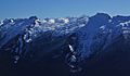
SSW aspect of Big Devil seen from the Lookout Mountain area
-
The Trapezoid (left) and Big Devil Peak (right) from the northwest


