
Birdsboro, Pennsylvania facts for kids
Quick facts for kids
Birdsboro, Pennsylvania
|
|
|---|---|

Birdsboro in 1890
|
|

Location of Birdsboro in Berks County, Pennsylvania
|
|

Birdsboro, Pennsylvania
Location in Pennsylvania

Birdsboro, Pennsylvania
Location in the United States
|
|
| Country | United States |
| State | Pennsylvania |
| County | Berks |
| Area | |
| • Total | 1.35 sq mi (3.51 km2) |
| • Land | 1.32 sq mi (3.43 km2) |
| • Water | 0.03 sq mi (0.08 km2) |
| Elevation | 207 ft (63 m) |
| Population
(2020)
|
|
| • Total | 5,106 |
| • Density | 3,856.50/sq mi (1,488.88/km2) |
| Time zone | UTC-5 (EST) |
| • Summer (DST) | UTC-4 (EDT) |
| ZIP Code |
19508
|
| Area code(s) | 610 |
| FIPS code | 42-06504 |
Birdsboro is a small town, called a borough, in Berks County, Pennsylvania, United States. It's located along the Schuylkill River, about 8 miles (13 km) southeast of Reading. In 2020, about 5,106 people lived there. Birdsboro was once known for its large metal factories and machine shops, but these are no longer open.
Contents
History of Birdsboro
.jpg)
Birdsboro got its name from William Bird, an ironmaker. He started a forge (a place where metal is heated and shaped) on Hay Creek around 1740. His son, Marcus, later founded Hopewell Furnace in 1771. This furnace became the biggest producer of iron in the country during the American Revolution.
The Schuylkill Canal, a waterway built next to the river, was finished in 1827. It helped transport goods. Later, the Philadelphia and Reading Railroad was built in 1843 to carry coal.
Edward and George Brooke, who were related to the Bird family, started the Birdsboro Iron Foundry Company in 1867. This company later became the Birdsboro Steel Company in 1905. For 120 years, this steel plant was the main employer in Birdsboro. However, it closed in 1988 after a long workers' strike.
Birdsboro officially became a borough in 1872. It was formed from parts of Union and Robeson townships. Its population grew slowly over the years. For example, it went from 2,261 people in 1890 to 2,930 in 1910. By the 2000 census, the population was 5,064.
During World War II and the Korean War, a company called Armorcast Corporation built a factory in Birdsboro in 1944. This factory made tanks for the wars. It also closed in 1988.
In the 1980s and 1990s, new neighborhoods like Mansion Heights were built on the hills. This caused the town's population to grow quite a bit.
In 1987, heavy rains caused Hay Creek to flood. This damaged parts of Pennsylvania Route 82 and five bridges. After many years, officials decided not to rebuild most of the bridges. The old road is now a nature trail. In 2008, the PA 82 road name was removed from this area. This part of Birdsboro is now part of Hopewell Big Woods. It's a great place for hiking, fishing, and other outdoor activities.
St. Michael's Protestant Episcopal Church, Parish House and Rectory is an important historic building. It was added to the National Register of Historic Places in 1982.
Geography and Climate
Birdsboro is located in the southern part of Berks County. Its northern edge is the Schuylkill River. To the north is Exeter Township. Union Township is to the east, and Robeson Township is to the south and west.
The U.S. Census Bureau says Birdsboro covers about 1.37 square miles (3.54 km2) of land and water. Most of this, 1.34 square miles (3.46 km2), is land. The rest, 0.03 square miles (0.08 km2), is water. Birdsboro is on the northern edge of the Hopewell Big Woods. This is the largest area of connected forest in southeastern Pennsylvania.
What is the Climate Like?
Birdsboro has a climate with hot and humid summers. The winters are usually mild to cool. This type of weather is called a humid subtropical climate.
Population and People
In the 2000 census, 5,064 people lived in Birdsboro. There were 1,854 households and 1,379 families. The population density was about 3,646.2 inhabitants per square mile (1,407.8/km2) (how many people live per square mile).
| Historical population | |||
|---|---|---|---|
| Census | Pop. | %± | |
| 1880 | 1,705 | — | |
| 1890 | 2,261 | 32.6% | |
| 1900 | 2,264 | 0.1% | |
| 1910 | 2,930 | 29.4% | |
| 1920 | 3,290 | 12.3% | |
| 1930 | 3,542 | 7.7% | |
| 1940 | 3,313 | −6.5% | |
| 1950 | 3,158 | −4.7% | |
| 1960 | 3,025 | −4.2% | |
| 1970 | 3,196 | 5.7% | |
| 1980 | 3,481 | 8.9% | |
| 1990 | 4,222 | 21.3% | |
| 2000 | 5,064 | 19.9% | |
| 2010 | 5,163 | 2.0% | |
| 2020 | 5,106 | −1.1% | |
| Sources: | |||
About 41.1% of households had children under 18 living with them. Most households (60.9%) were married couples. The average household had 2.73 people.
The population included people of all ages. About 29.2% were under 18 years old. The median age was 35 years. This means half the people were younger than 35, and half were older.
The median income for a household in Birdsboro was $53,932. This means half the households earned more than this, and half earned less. About 2.7% of the total population lived below the poverty line.
Local Education for Kids
Children in Birdsboro go to public schools in the Daniel Boone Area School District.
- Students in kindergarten through 2nd grade attend the Daniel Boone Area Primary Center.
- Grades 3-5 go to the Daniel Boone Area Intermediate Center.
- Grades 6-8 attend the Daniel Boone Area Middle School.
- High school students (grades 9-12) go to Daniel Boone Area High School.
Kids in grades K-8 also have another choice: they can attend Immaculate Conception Academy. This is a Catholic school in nearby Douglassville.
There's also a school called Robeson Elementary School. It has a Birdsboro mailing address, but it's actually in Robeson Township. So, kids living in Birdsboro don't go to that school.
Transportation Around Birdsboro
_at_North_Furnace_Street_in_Birdsboro,_Berks_County,_Pennsylvania.jpg)
As of 2020, Birdsboro had about 18.29 miles (29.43 km) of public roads. Most of these roads (16.03 miles (25.80 km)) are taken care of by the borough itself. The rest (2.26 miles (3.64 km)) are maintained by the Pennsylvania Department of Transportation (PennDOT).
Pennsylvania Route 724 is the main street in Birdsboro. It goes west towards Shillington (near Reading) and east to South Pottstown. Pennsylvania Route 345 starts in the center of town and goes north. It crosses the Schuylkill River to U.S. Route 422 in Baumstown. PA 345 also goes south into French Creek State Park and Hopewell Furnace National Historic Site.
Notable People from Birdsboro
Many interesting people have connections to Birdsboro:
- Daniel Boone, a famous pioneer and frontiersman.
- Lucile Carter, a survivor of the Titanic disaster.
- Chad Hurley, one of the people who started YouTube.
- Richie Kotzen, a talented guitarist who played in bands like The Winery Dogs, Mr. Big, and Poison.
Historic Birdsboro Buildings
-
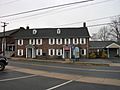
William Bird Mansion (1751), now the Birdsboro Community Center.
-
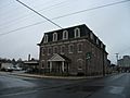
Brooke Hall (around 1875), now an M&T Bank branch.
-
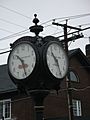
The town clock, located at East Main & Mill Streets.
-
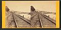
The Reading Railroad below Birdsboro, from about 1865–85.
-
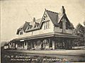
The Philadelphia & Reading Railroad Station (around 1875), designed by Frank Furness. It was taken down in 1963.
-
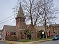
St. Michael's Episcopal Church (1884–85), also designed by Frank Furness. It is listed on the National Register of Historic Places and is now the New First Baptist Church of Birdsboro.
.jpg)
.jpg)
.jpg)
_below_Birdsboro,_from_Robert_N._Dennis_collection_of_stereoscopic_views.jpg)


See also
 In Spanish: Birdsboro para niños
