Black Ash Creek facts for kids
Quick facts for kids Black Ash Creek |
|
|---|---|

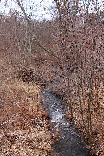
Black Ash Creek looking downstream
|
|
| Other name(s) | Wolf Creek, Wolf's Creek |
| Physical characteristics | |
| Main source | valley near Booth Road in Ross Township, Luzerne County, Pennsylvania between 1,180 and 1,200 feet (360 and 370 m) |
| River mouth | Rogers Creek in Ross Township, Luzerne County, Pennsylvania 968 ft (295 m) 41°13′20″N 76°12′51″W / 41.22235°N 76.21406°W |
| Length | 1.9 mi (3.1 km) |
| Basin features | |
| Progression | Rogers Creek → Huntington Creek → Fishing Creek → Susquehanna River → Chesapeake Bay |
| Basin size | 1.46 sq mi (3.8 km2) |
Black Ash Creek is a small stream in Luzerne County, Pennsylvania, in the United States. It's also known as Wolf Creek or Wolf's Creek. This creek flows into Rogers Creek.
Black Ash Creek is about 1.9 miles (3.1 kilometers) long. It flows through an area called Ross Township. The land area that collects water for the creek, called its watershed, is about 1.46 square miles (3.78 square kilometers). The water in Black Ash Creek is considered clean and healthy.
Contents
Where Does Black Ash Creek Flow?
Black Ash Creek starts in a valley near Booth Road in Ross Township. It flows mostly towards the south. Along its path, it crosses State Route 4019.
After flowing for a while, the creek turns southwest. Then it turns south again. Finally, it leaves its valley and meets up with Rogers Creek. Black Ash Creek joins Rogers Creek about 2.82 miles (4.54 kilometers) before Rogers Creek reaches its own end.
Water and Land Around the Creek
The land where Black Ash Creek ends is about 968 feet (295 meters) above sea level. Where the creek begins, the land is higher. It's between 1180 and 1200 feet (360 to 366 meters) above sea level.
The ground near the end of Black Ash Creek is mostly made of alluvium. This is a type of soil with gravel, sand, and silt, and sometimes large boulders. There's also some "Wisconsinan Outwash" nearby.
Most of the land around the creek has a type of soil called "Wisconsinan Till." This soil was left behind by glaciers. You can also find patches of solid bedrock made of sandstone and shale.
It's good news that Black Ash Creek is not considered a polluted or "impaired" stream. This means its water quality is good.
The Creek's Watershed
The watershed of Black Ash Creek covers about 1.46 square miles (3.78 square kilometers). This is the entire area where rainwater drains into the creek.
The creek is located completely within the Shickshinny area, as mapped by the United States Geological Survey. It's also not far from a community called Bloomingdale.
A Bit of History
Black Ash Creek was officially added to the Geographic Names Information System on August 2, 1979. This system keeps track of names for places like rivers and mountains. Its special ID number there is 1169687.
The creek is also known by another name, Wolf Creek. This name can be seen on maps published by the Pennsylvania Department of Transportation.
There was talk about building a bridge over Black Ash Creek a long time ago, in the early 1900s. However, no one offered to build the bridge in 1900, so it didn't happen then.
 | Selma Burke |
 | Pauline Powell Burns |
 | Frederick J. Brown |
 | Robert Blackburn |

