Black nor'easter facts for kids
A black nor'easter is a powerful storm that happens on Australia's east coast. It mainly affects areas from southeastern Queensland down to southern New South Wales. These storms usually occur between late spring and early autumn. They are known for bringing heavy rainfall and strong winds.
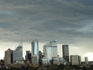
Black nor'easters get their name because the clouds are so dark. They can make the daytime look as dark as twilight. These storms can also make warm days feel cooler because of the thick, moist clouds.
Contents
What is a Black Nor'easter?

A black nor'easter forms when moist, cool air from the south mixes with warm, humid air from the north. This mix creates very dark, rain-filled clouds. The winds come from the northeast.
The Sydney Morning Herald first described a black nor'easter on October 30, 1911. They wrote about strong winds and thundery weather with rain.
How is it Different from a Sea Breeze?
Northeasterly sea breezes are common on the NSW coast in summer. They happen because of temperature differences between the sea and land. However, a black nor'easter is much stronger. It brings moist, gale-force winds, which are around 60 kilometres per hour. These strong winds and dark clouds often lead to thunderstorms, heavy rain, and sometimes hail.
Black Nor'easters vs. East Coast Lows
A black nor'easter is different from an East coast low (ECL). ECLs usually happen in cooler months. Black nor'easters happen in warmer months and start from the northeast.
However, a black nor'easter can sometimes turn into an east coast low as it moves south. This happened during the 2022 eastern Australia floods. Unlike ECLs, black nor'easters can also bring heavy rain to inland areas of New South Wales and Queensland.
How Black Nor'easters Form

Black nor'easters often involve cut-off low systems. These systems mix with coastal troughs that are full of moisture. This pulls in humid, tropical air from the north. When cold air high up cools down this warm, wet air, a lot of moisture falls as rain. This mix often causes heavy rainfall and flooding on the east coast.
Warm sea temperatures from the East Australian Current (EAC) can make these storms even stronger.
What Makes Them Powerful?
Forecasters explain that a black nor'easter can form when an unstable low pressure trough from inland Australia combines with a moisture-filled trough near the East Coast.
They can also form when a cool air mass from the Great Australian Bight creates a low-pressure system in the southeast. At the same time, a coastal trough, made stronger by warm sea temperatures, brings in a lot of moisture. This moisture is then carried south by moist northeasterly winds. When it meets cooler air higher up, it turns into rain.
These storms can cause a big increase in wave heights along the east coast. When a black nor'easter combines with an east coast low, it can create very intense storm waves.
Impacts of Black Nor'easters
Black nor'easters bring strong winds and heavy rain. These conditions can cause many problems, especially in New South Wales and Sydney.
- Falling Trees: Strong winds can knock down trees, which has sadly led to deaths.
- Flooding: The heavy rain often causes severe floods.
- Power Outages: Storms can strike down power lines, leaving thousands of homes and businesses without electricity.
- Property Damage: Roofs can collapse, and homes can be damaged.
Major Black Nor'easter Events
- February 2010 Sydney Storm: Sydney had some of its heaviest rain in 25 years. This storm also brought strong winds and thunderstorms. It caused power cuts and damaged homes. The rain was from the remains of ex-tropical Cyclone Olga and a lot of moisture from the northeast.
- November 2013 Hornsby Tornado: A tornado hit Hornsby, a suburb in Sydney. The tornado was 2 kilometres long and 50 metres wide. It blew off roofs and knocked down large trees. Winds reached 140 km/h, and 12 people were injured.
- June 2016 Coastal Erosion: A black nor'easter swell changed parts of the east Australian coastline. Backyards at Collaroy fell into the sea, and nearby houses were damaged. Bridges and walkways were also destroyed. Many north-facing beaches experienced erosion.
- February 2020 Sydney Floods: Between February 7 and 9, 2020, the Sydney area had its heaviest rain in 30 years. This caused widespread flooding and strong winds. Over 100,000 homes lost power. Sydney CBD recorded about 391.6 mm of rain in three days. The storm also affected the South Coast, Blue Mountains, Southern Highlands, Hunter Valley, and Central Coast.
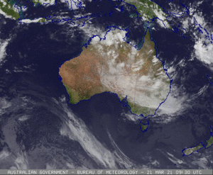
- March 2021 Sydney Tornado and Floods: On March 20, 2021, a tornado hit Chester Hill in western Sydney. It damaged homes and knocked down trees, leaving thousands without power. The storm also brought record rainfall to the north coast. Towns near Port Macquarie, like Kendall, saw over 400 millimetres of rain. This heavy rain was caused by a high-pressure system in the Tasman Sea that pushed a strong, moist low-pressure trough towards the NSW coast.
- February/March 2022 Eastern Australia Floods: In late February and early March 2022, a black nor'easter lasted for almost two weeks. It caused severe flooding in major cities like Brisbane, Lismore, and western Sydney. This nor'easter turned into an east coast low as it moved south.
- July 2022 New South Wales Floods: The July 2022 floods were also caused by a black nor'easter. Tropical moisture from northern Australia mixed with a low-pressure trough on the New South Wales coast. This system later became an east coast low.
- April 2024 Floods: Between April 4 and 6, 2024, a black nor'easter brought heavy rain to southern Queensland and New South Wales. Two people died in the floods. Penrith recorded its heaviest rainfall ever, with 167mm. Over 100mm fell in parts of southern Queensland and the NSW Northern Rivers on April 4, causing floods.
See also
- Southerly buster
- Australian east coast low
- Severe weather events in Sydney


