Blue Ridge, Georgia facts for kids
Quick facts for kids
Blue Ridge, Georgia
|
||
|---|---|---|
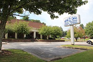
City hall
|
||
|
||
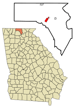
Location in Fannin County and the state of Georgia
|
||
| Country | United States | |
| State | Georgia | |
| County | Fannin | |
| Area | ||
| • Total | 2.68 sq mi (6.93 km2) | |
| • Land | 2.68 sq mi (6.93 km2) | |
| • Water | 0.00 sq mi (0.00 km2) | |
| Elevation | 1,762 ft (537 m) | |
| Population
(2020)
|
||
| • Total | 1,253 | |
| • Density | 468.06/sq mi (180.73/km2) | |
| Time zone | UTC-5 (Eastern (EST)) | |
| • Summer (DST) | UTC-4 (EDT) | |
| ZIP code |
30513
|
|
| Area codes | 706/762 | |
| FIPS code | 13-08928 | |
| GNIS feature ID | 0331197 | |
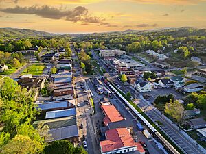
Blue Ridge is a city located in Fannin County, Georgia, in the United States. It is the largest city in Fannin County and also its county seat, which means it's where the county government is located. In 2020, about 1,253 people lived there.
Contents
History of Blue Ridge
Before Europeans arrived, the land where Blue Ridge now stands was home to the Cherokee people. They and other Indigenous peoples lived there for thousands of years.
The city of Blue Ridge was officially started in 1886. This happened when the Marietta and North Georgia Railroad built its tracks to this area. Blue Ridge became an official city in 1887. Later, in 1895, it became the main town for Fannin County, taking over from Morganton.
Blue Ridge Scenic Railway
Blue Ridge is famous for the Blue Ridge Scenic Railway. This is a special train that has been restored to look like old trains. It offers a fun four-hour trip that covers 26 miles. The train travels along the beautiful Toccoa River. It goes to the nearby towns of McCaysville, Georgia and Copperhill, Tennessee.
The original train tracks were first built in Marietta, Georgia. They reached Blue Ridge and the areas around it in 1886.
Geography and Climate
Blue Ridge is located in the southern part of Fannin County. Its exact spot is 34°52′6″N 84°19′16″W / 34.86833°N 84.32111°W. The city sits on a special dividing line. To the north, water flows into the Tennessee River. To the south, water flows into the Alabama River.
Major roads like U.S. Route 76 and Georgia State Route 515 (also called Zell Miller Mountain Parkway) run through the western side of the city. These roads connect Blue Ridge to other towns. For example, Blairsville is about 22 miles east, and Ellijay is about 15 miles southwest. Georgia State Route 5 goes north for about 10 miles to McCaysville, which is right at the Tennessee border. The big city of Atlanta is about 93 miles south of Blue Ridge.
The United States Census Bureau says that Blue Ridge covers about 2.68 square miles (6.93 square kilometers) of land. There is no water area within the city limits.
What is the Climate Like in Blue Ridge?
Blue Ridge has a climate called Cfa. This means it has warm, humid summers and mild winters. It is also influenced by the nearby Appalachian Mountains.
| Climate data for Blue Ridge, Georgia | |||||||||||||
|---|---|---|---|---|---|---|---|---|---|---|---|---|---|
| Month | Jan | Feb | Mar | Apr | May | Jun | Jul | Aug | Sep | Oct | Nov | Dec | Year |
| Record high °F (°C) | 74 (23) |
78 (26) |
85 (29) |
91 (33) |
94 (34) |
100 (38) |
103 (39) |
101 (38) |
98 (37) |
92 (33) |
83 (28) |
76 (24) |
103 (39) |
| Mean daily maximum °F (°C) | 50 (10) |
54 (12) |
61 (16) |
71 (22) |
78 (26) |
84 (29) |
88 (31) |
87 (31) |
81 (27) |
72 (22) |
62 (17) |
52 (11) |
70 (21) |
| Daily mean °F (°C) | 38 (3) |
41 (5) |
48 (9) |
56 (13) |
64 (18) |
71 (22) |
76 (24) |
75 (24) |
68 (20) |
57 (14) |
48 (9) |
40 (4) |
57 (14) |
| Mean daily minimum °F (°C) | 26 (−3) |
28 (−2) |
34 (1) |
40 (4) |
49 (9) |
58 (14) |
63 (17) |
62 (17) |
54 (12) |
42 (6) |
34 (1) |
28 (−2) |
43 (6) |
| Record low °F (°C) | −16 (−27) |
−5 (−21) |
2 (−17) |
17 (−8) |
29 (−2) |
37 (3) |
47 (8) |
46 (8) |
30 (−1) |
19 (−7) |
−1 (−18) |
−8 (−22) |
−16 (−27) |
| Average precipitation inches (mm) | 5.8 (150) |
5.5 (140) |
6.4 (160) |
4.9 (120) |
5.0 (130) |
4.6 (120) |
5.4 (140) |
4.8 (120) |
4.5 (110) |
3.3 (84) |
5.0 (130) |
5.0 (130) |
60.2 (1,534) |
Population of Blue Ridge
| Historical population | |||
|---|---|---|---|
| Census | Pop. | %± | |
| 1890 | 264 | — | |
| 1900 | 1,148 | 334.8% | |
| 1910 | 898 | −21.8% | |
| 1920 | 904 | 0.7% | |
| 1930 | 1,190 | 31.6% | |
| 1940 | 1,362 | 14.5% | |
| 1950 | 1,718 | 26.1% | |
| 1960 | 1,406 | −18.2% | |
| 1970 | 1,602 | 13.9% | |
| 1980 | 1,376 | −14.1% | |
| 1990 | 1,336 | −2.9% | |
| 2000 | 1,210 | −9.4% | |
| 2010 | 1,290 | 6.6% | |
| 2020 | 1,253 | −2.9% | |
| U.S. Decennial Census | |||
How Many People Live in Blue Ridge?
As of the 2020 United States census, there were 1,253 people living in Blue Ridge. These people made up 476 households, and 249 of those were families.
Most people in Blue Ridge are White. Here's a quick look at the different groups in 2020:
| Race | Number of People | Percentage |
|---|---|---|
| White (not Hispanic) | 1,121 | 89.47% |
| Black or African American (not Hispanic) | 9 | 0.72% |
| Native American | 4 | 0.32% |
| Asian | 13 | 1.04% |
| Other/Mixed | 36 | 2.87% |
| Hispanic or Latino | 70 | 5.59% |
Back in the 2010 United States Census, there were 1,290 people living in the city. About 92.1% were White, 1.2% Black, and 0.5% Asian. About 4.5% of the people were Hispanic or Latino.
In the year 2000, there were 1,210 people. The average household had about 2.14 people, and the average family had about 2.81 people. The median age in the city was 39 years old. This means half the people were younger than 39 and half were older.
Education
Blue Ridge has good schools for students from pre-school all the way to high school.
Fannin County School District
The Fannin County School District is in charge of the schools here. It has three elementary schools, one middle school, and one high school. There are over 179 full-time teachers who teach more than 3,212 students.
The schools in the district are:
- Blue Ridge Elementary School
- East Fannin Elementary School
- West Fannin Elementary School
- Fannin County Middle School
- Fannin County High School
University of North Georgia Campus
In 2015, the University of North Georgia (UNG) opened a campus right in Blue Ridge. This means students can go to college classes close to home.
Notable People from Blue Ridge
Some well-known people have come from Blue Ridge:
- Lake Underwood – He was an entrepreneur, inventor, and also owned and drove racecars.
- Mark Wills – A popular country music singer.
Images for kids
See also
 In Spanish: Blue Ridge (Georgia) para niños
 | George Robert Carruthers |
 | Patricia Bath |
 | Jan Ernst Matzeliger |
 | Alexander Miles |


