Boardman, Oregon facts for kids
Quick facts for kids
Boardman, Oregon
|
|
|---|---|
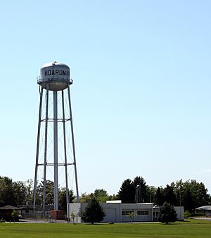
Boardman water tower (before 2017)
|
|
| Motto(s):
On the river, on the way
|
|
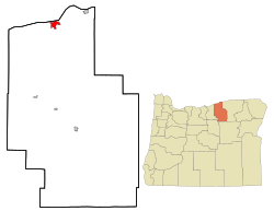
Location in Morrow County and Oregon
|
|
| Country | United States |
| State | Oregon |
| County | Morrow |
| Incorporated | May 20, 1921 |
| Area | |
| • Total | 4.43 sq mi (11.47 km2) |
| • Land | 4.03 sq mi (10.43 km2) |
| • Water | 0.40 sq mi (1.04 km2) |
| Elevation | 308 ft (94 m) |
| Population
(2020)
|
|
| • Total | 3,828 |
| • Density | 950.11/sq mi (366.86/km2) |
| Time zone | UTC-8 (Pacific) |
| • Summer (DST) | UTC-7 (Pacific) |
| ZIP code |
97818
|
| Area code(s) | 541 |
| FIPS code | 41-07200 |
| GNIS feature ID | 1136082 |
Boardman is a city in Oregon, located right by the Columbia River. It's also near Interstate 84, a major highway. In 2020, about 3,828 people lived there. Boardman is the biggest town in Morrow County.
Contents
History of Boardman
Boardman was first settled in 1903 by Samuel H. Boardman. He later became the first leader of the Oregon State Parks System. Samuel and his wife worked for 13 years to bring water to their land. During this time, his wife taught school. Samuel also worked on building railroads.
The Union Pacific Railroad built a station in Boardman. The town was officially planned in 1916. Around this time, Samuel Boardman started working for the Oregon State Highway Department. He helped create parks along the roads.
The Boardman post office opened in 1916. The city officially became a city in 1921. In the 1960s, the John Day Dam was built on the Columbia River. This caused the city to move south, away from the water. A new lake, Lake Umatilla, covered much of the old city area.
South of Boardman, the U.S. Army Air Force built a training area in 1941. In 1960, the Air Force gave this area to the U.S. Navy. It is now called the Naval Weapons Systems Training Facility Boardman. This area is mainly used by NAS Whidbey Island and the Oregon National Guard for training.
Geography and Climate
Boardman is in northeastern Oregon. It sits along Interstate 84, south of the Columbia River. The city is about 308 feet (94 meters) above sea level. It is about 25 miles (40 km) west of Hermiston. It is also about 164 miles (264 km) east of Portland.
The city covers about 4.17 square miles (10.80 square kilometers). Most of this area is land, with a small part being water.
Boardman's Climate
Boardman has a dry climate, known as a steppe climate. This means it gets less rain than other places.
| Climate data for Boardman, Oregon, 1991–2020 normals, extremes 1971–present | |||||||||||||
|---|---|---|---|---|---|---|---|---|---|---|---|---|---|
| Month | Jan | Feb | Mar | Apr | May | Jun | Jul | Aug | Sep | Oct | Nov | Dec | Year |
| Record high °F (°C) | 70 (21) |
74 (23) |
80 (27) |
92 (33) |
102 (39) |
113 (45) |
110 (43) |
107 (42) |
100 (38) |
90 (32) |
76 (24) |
73 (23) |
113 (45) |
| Mean maximum °F (°C) | 58.2 (14.6) |
61.6 (16.4) |
69.6 (20.9) |
80.5 (26.9) |
90.6 (32.6) |
97.3 (36.3) |
103.4 (39.7) |
101.7 (38.7) |
92.7 (33.7) |
80.1 (26.7) |
67.3 (19.6) |
58.9 (14.9) |
104.2 (40.1) |
| Mean daily maximum °F (°C) | 42.0 (5.6) |
48.3 (9.1) |
57.6 (14.2) |
66.1 (18.9) |
75.2 (24.0) |
81.7 (27.6) |
91.3 (32.9) |
90.0 (32.2) |
80.6 (27.0) |
65.8 (18.8) |
51.0 (10.6) |
41.6 (5.3) |
65.9 (18.9) |
| Daily mean °F (°C) | 35.3 (1.8) |
38.9 (3.8) |
45.7 (7.6) |
53.0 (11.7) |
61.5 (16.4) |
68.1 (20.1) |
75.7 (24.3) |
74.3 (23.5) |
65.2 (18.4) |
53.1 (11.7) |
42.1 (5.6) |
35.4 (1.9) |
54.0 (12.2) |
| Mean daily minimum °F (°C) | 28.7 (−1.8) |
29.5 (−1.4) |
33.8 (1.0) |
39.8 (4.3) |
47.8 (8.8) |
54.6 (12.6) |
60.0 (15.6) |
58.7 (14.8) |
49.7 (9.8) |
40.3 (4.6) |
33.2 (0.7) |
29.1 (−1.6) |
42.1 (5.6) |
| Mean minimum °F (°C) | 12.0 (−11.1) |
14.8 (−9.6) |
21.4 (−5.9) |
28.3 (−2.1) |
34.7 (1.5) |
44.2 (6.8) |
49.1 (9.5) |
47.4 (8.6) |
38.3 (3.5) |
26.1 (−3.3) |
18.3 (−7.6) |
14.0 (−10.0) |
5.4 (−14.8) |
| Record low °F (°C) | −13 (−25) |
−13 (−25) |
2 (−17) |
21 (−6) |
29 (−2) |
35 (2) |
37 (3) |
39 (4) |
25 (−4) |
11 (−12) |
−9 (−23) |
−15 (−26) |
−15 (−26) |
| Average precipitation inches (mm) | 1.28 (33) |
0.92 (23) |
0.70 (18) |
0.64 (16) |
0.80 (20) |
0.55 (14) |
0.14 (3.6) |
0.18 (4.6) |
0.25 (6.4) |
0.74 (19) |
0.98 (25) |
1.38 (35) |
8.56 (217.6) |
| Average snowfall inches (cm) | 1.2 (3.0) |
1.4 (3.6) |
0.2 (0.51) |
0.0 (0.0) |
0.0 (0.0) |
0.0 (0.0) |
0.0 (0.0) |
0.0 (0.0) |
0.0 (0.0) |
0.1 (0.25) |
0.0 (0.0) |
0.8 (2.0) |
3.7 (9.36) |
| Average precipitation days (≥ 0.01 in) | 8.8 | 6.3 | 6.3 | 4.9 | 5.1 | 3.4 | 1.1 | 1.6 | 2.1 | 5.1 | 7.4 | 9.9 | 62.0 |
| Average snowy days (≥ 0.1 in) | 0.5 | 0.5 | 0.2 | 0.0 | 0.0 | 0.0 | 0.0 | 0.0 | 0.0 | 0.0 | 0.0 | 1.2 | 2.4 |
| Source 1: NOAA | |||||||||||||
| Source 2: National Weather Service | |||||||||||||
People of Boardman
| Historical population | |||
|---|---|---|---|
| Census | Pop. | %± | |
| 1920 | 113 | — | |
| 1930 | 100 | −11.5% | |
| 1940 | 110 | 10.0% | |
| 1950 | 120 | 9.1% | |
| 1960 | 153 | 27.5% | |
| 1970 | 192 | 25.5% | |
| 1980 | 1,261 | 556.8% | |
| 1990 | 1,387 | 10.0% | |
| 2000 | 2,855 | 105.8% | |
| 2010 | 3,220 | 12.8% | |
| 2020 | 3,828 | 18.9% | |
| source: | |||
Boardman is part of the Pendleton–Hermiston area. This area is called a Micropolitan Statistical Area.
How Many People Live Here?
In 2010, there were 3,220 people living in Boardman. These people lived in 964 homes. About 759 of these were families. The city had about 850 people per square mile.
Many different groups of people live in Boardman. About 60% of the people were White. About 33% were from other races. About 62% of the people were Hispanic or Latino.
Many homes (53%) had children under 18 living there. The average home had about 3.34 people. The average family had about 3.70 people. The average age of people in Boardman was 27.5 years old. About 35% of residents were under 18.
Boardman's Economy
Boardman has several important employers. As of 2013, the biggest ones included Lamb Weston (which makes potato products) and Oregon Potato Company. Other large employers were Portland General Electric (PGE), the Morrow County School District, Boardman Foods, and Amazon S3.
Port of Morrow
The Port of Morrow is next to Boardman. It is Oregon's second-largest port. It is located on the Columbia River. The port also has two gas-fired power plants run by PGE.
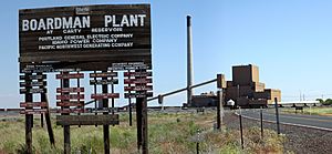
PGE used to have a coal-fired power plant in Boardman. It opened in 1980 and closed in October 2020. This was the last coal-fired power plant in Oregon. The plant was taken down in 2022. It used to produce a lot of power. It was also the biggest source of greenhouse gases in Oregon.
Other Important Businesses
The Umatilla Chemical Depot is about 10 miles (16 km) east of Boardman. This site used to store chemical weapons. The Irrigon Fish Hatchery is about 7 miles (11 km) east of Boardman. Threemile Canyon Farms is the largest farm in Boardman.
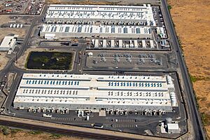
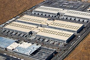
In 2008, Amazon started building a large data center at the Port of Morrow. A data center is like a huge computer server farm. It needs a lot of electricity. This center helps run Amazon Web Services (AWS). By 2011, this Amazon data center was working. It was one of three Amazon data centers in the region.
Other tech companies also have data centers nearby. Google has one in The Dalles. Apple and Facebook have them in Prineville. By 2018, Amazon had two data centers in Boardman and one in Umatilla. They planned to build four more in the area. These data centers are part of AWS US-West-2 (Oregon) region.
Since 2007, a company called Alto Ingredients (formerly Pacific Ethanol) has run an ethanol plant in Boardman. This plant can make up to 40 million gallons (151 million liters) of ethanol each year from grains. Another company, ZeaChem, built a small plant to make ethanol from wood waste. They hoped to build a much bigger plant. However, they stopped production in 2013 due to money problems.
Transportation in Boardman
Boardman Airport is about 4 miles (6 km) southwest of the city. The Port of Morrow owns it. This airport is mainly used for small planes and local flights. Midcolumbia Bus Company also serves the Boardman area.
See also
 In Spanish: Boardman (Oregón) para niños
 | Anna J. Cooper |
 | Mary McLeod Bethune |
 | Lillie Mae Bradford |


