Boston Run facts for kids
Quick facts for kids Boston Run |
|
|---|---|

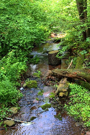
Boston Run looking downstream in Ricketts Glen State Park
|
|
| Physical characteristics | |
| Main source | southern base of a mountain in Fairmount Township, Luzerne County, Pennsylvania between 1,480 and 1,500 feet (450 and 460 m) |
| River mouth | Kitchen Creek in Kitchen Creek Gorge in Fairmount Township, Luzerne County, Pennsylvania 1,197 ft (365 m) ACoordinates: Unknown argument format |
| Length | 1.2 mi (1.9 km) |
| Basin features | |
| Progression | Kitchen Creek → Huntington Creek → Fishing Creek → Susquehanna River → Chesapeake Bay |
| Basin size | 0.66 sq mi (1.7 km2) |
Boston Run is a small stream, also called a tributary, that flows into Kitchen Creek in Luzerne County, Pennsylvania. It is about 1.2 miles (1.9 kilometers) long. The stream flows through Fairmount Township. The area of land that drains water into Boston Run is about 0.66 square miles (1.7 square kilometers).
Cool fact: You can find wild trout living and reproducing naturally in Boston Run! There are also very old forests, called old-growth forests, nearby.
Contents
Where Boston Run Flows
Boston Run starts at the bottom of a mountain in Fairmount Township. It flows southwest for a short distance. Then, it turns west for a bit.
The stream then turns southwest again. It passes through a small pond and goes under Pennsylvania Route 118. After that, it turns west-southwest. Finally, it joins Kitchen Creek in a deep valley called Kitchen Creek Gorge. Boston Run meets Kitchen Creek about 5.52 miles (8.88 kilometers) before Kitchen Creek ends.
Land and Rocks Around the Stream
The land around Boston Run is interesting! Near where the stream joins Kitchen Creek, the ground is about 1,197 feet (365 meters) above sea level. Where the stream begins, it's higher, between 1,480 and 1,500 feet (451 and 457 meters) above sea level. Boston Run is a pretty small stream.
The ground near the lower part of Boston Run is mostly made of sandy and gravelly soil. This soil was left behind by ancient glaciers. Near the mouth of the stream, you can find solid bedrock made of sandstone and shale. In the upper parts of the stream, the ground is mostly rocky soil, also left by glaciers. There's also a small area where the ground has been moved or filled in by people, especially where the stream crosses Pennsylvania Route 118.
The Boston Run Area
The entire area of land that drains water into Boston Run is called its watershed. This watershed covers about 0.66 square miles (1.7 square kilometers). Boston Run is located entirely within an area mapped by the United States Geological Survey called the Red Rock quadrangle.
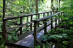
There is at least one bridge that crosses Boston Run. This bridge is part of a hiking trail.
History and Fun Activities
Boston Run was officially added to the Geographic Names Information System on August 2, 1979. This system helps keep track of place names.
A hiking trail called the Evergreen Trail crosses Boston Run twice. This trail is about 1 mile (1.6 kilometers) long. It has a small elevation change of about 50 feet (15 meters), which means it's not too steep. A book called Hiking the Endless Mountains describes this trail as easy. There's also a special natural area near the stream called the Boston Run Nature Area.
Animals and Plants
As we mentioned, wild trout live and reproduce naturally in Boston Run. They can be found from the very beginning of the stream all the way to where it joins Kitchen Creek.
In 2014, a very large tulip poplar tree was noted along Boston Run. The area around the stream is also home to an old-growth forest. These are forests that have been growing for a very long time without being cut down.
 | Tommie Smith |
 | Simone Manuel |
 | Shani Davis |
 | Simone Biles |
 | Alice Coachman |


