Burra, New South Wales facts for kids
Quick facts for kids BurraNew South Wales |
|||||||||||||||
|---|---|---|---|---|---|---|---|---|---|---|---|---|---|---|---|

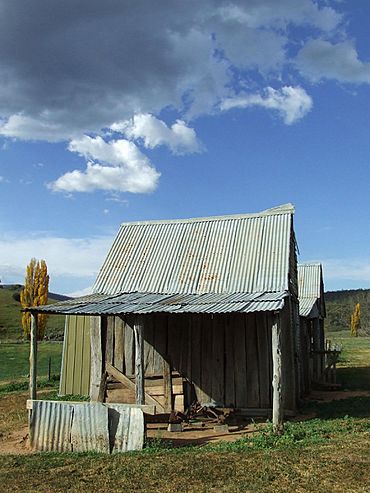
London Bridge Homestead, an early Burra residence now contained within the Googong Foreshores.
|
|||||||||||||||
| Population | 790 (2021 census) | ||||||||||||||
| Postcode(s) | 2620 | ||||||||||||||
| Location |
|
||||||||||||||
| LGA(s) | Queanbeyan-Palerang Region | ||||||||||||||
| County | Murray | ||||||||||||||
| Parish | Burra | ||||||||||||||
| State electorate(s) | Monaro | ||||||||||||||
| Federal Division(s) | Eden-Monaro | ||||||||||||||
|
|||||||||||||||
Burra is a small rural area in New South Wales, Australia. It is about 20 kilometers south of Queanbeyan, New South Wales. Burra is part of the Queanbeyan-Palerang Region. In 2021, about 790 people lived there.
Contents
A Look at Burra's Past
The Ngarigo people were the first to live in the Burra area. Their lands stretched south towards the Australian Alps. Early European settlers called the first camp 'The Creek'. Later, it became known as "The Burra". This name might come from a local Aboriginal word like "berra," which means boomerang.
Early European Settlement
Farming and clearing of land started in the 1830s and 1860s. Farms were set up in the Burra Valley. Some of these early farms were Warm Corner, KT Park, Burra Station, London Bridge, and Lagoon.
By the 1920s, enough people lived in Burra to have two cricket clubs. One club played at Burra park, and the other near Urila.
Modern Development
In the 1960s, Canberra grew bigger. Because of this, Burra's larger land blocks were divided into smaller ones. This created new areas like those around Candy Road, Badgery Road, and Plummers Road. Today, most of Burra has been divided this way.
Burra's Climate
Burra is at the top of the Monaro tablelands. This means it has a cooler climate. Temperatures are usually a few degrees colder than in Canberra and Queanbeyan. It is common for light snow to fall in winter.
Historic Places in Burra
Burra has some important historic sites. These places are protected because of their special history.
- London Bridge Road: Googong Foreshores
Burra's Natural Environment
Some parts of the Burra valley have always been open and without trees. In other areas, you can still find old woodlands. These woodlands have trees like Snow Gum, Candlebark, and Yellow Box. You can also see Apple Box and Small Leaved Peppermint.
Trees and Plants
In cooler, low-lying areas, you might find Black Sally and Manna Gum. The hills to the east are rocky and dry. They mainly have Small Leafed Peppermint, Brittle Gum, and Scribbly Gum. This area has not been heavily farmed. It remains in its natural state. In 2001, part of it became the Burra Creek Nature Reserve.
The western hills, including Mount Campbell and Gibraltar Peak, have different forests. These forests are similar to the wet sclerophyll forests found further west. You can see these types of forests in the Mount Clear Range and Namadgi National Park.
Rocks and Geology
Most of Burra sits on top of rocks called the Colinton Volcanics. These rocks are light grey tuff and lava. They were formed about 425 million years ago during the Silurian period. This happened when large volcanoes erupted underwater.
An old crack in the Earth's crust, called a fault, runs near Burra Road. East of this fault are even older rocks. These are sandy sediments from the Ordovician period. They were laid down by a huge river flowing from the supercontinent Gondwana.
London Bridge Arch
Near this fault, there are some limestone rocks. One of these limestone areas forms the famous 'London Bridge' natural arch. This arch goes over the Burra Creek. Inside this limestone, you can find small pieces of old fossils. These include parts of crinoid stems, brachiopods, and tabulate corals. In the 1920s and 1930s, people looked for iron, lead, and silver along this fault.
See also
 In Spanish: Burra (Nueva Gales del Sur) para niños
 | Emma Amos |
 | Edward Mitchell Bannister |
 | Larry D. Alexander |
 | Ernie Barnes |


