Butaritari facts for kids
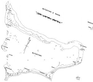
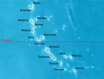
Map of Butaritari
|
|
 |
|
| Geography | |
|---|---|
| Location | Pacific Ocean |
| Coordinates | 3°10′04″N 172°49′33″E / 3.16778°N 172.82583°E |
| Archipelago | Gilbert Islands |
| Area | 13.49 km2 (5.21 sq mi) |
| Highest elevation | 3 m (10 ft) |
| Administration | |
| Largest village | Taubukinmeang |
| Demographics | |
| Population | 3,224 (2015 Census) |
| Pop. density | 322 /km2 (834 /sq mi) |
| Ethnic groups | I-Kiribati 90.6% |
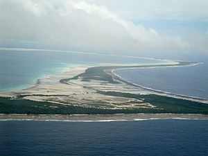
Butaritari is a beautiful atoll (a ring-shaped coral island) in the Pacific Ocean. It's part of the island nation of Kiribati. The atoll looks a bit like a square. Its southern and southeastern parts have a long, almost unbroken line of small islands.
The reef around Butaritari is continuous, but there are hardly any islands on its northern side. Two small islands, Bikati and Bikatieta, are found at the far northwest tip. Other small islands are scattered between channels on the western side.
Butaritari's lagoon (the calm water inside the atoll) is very deep. This means big ships can sail into it, even though the entrances are a bit narrow. It's known as the most fertile of the Gilbert Islands. This is because it has good soil (for an atoll) and gets a lot of rain.
The land area of Butaritari atoll is about 13.49 square kilometers. In 2015, its population was 3,224 people. During World War II, the United States Armed Forces called Butaritari "Makin Atoll." It was the location of a big fight called the Battle of Makin. Locally, Makin is a different atoll, only 3 kilometers northeast of Butaritari. You can even see it from Butaritari! People on both atolls speak a similar version of the Gilbertese language.
Contents
Exploring Butaritari's Geography
Butaritari is the second most northern island in the Gilbert Islands. Just 3 kilometers to its northeast is Makin. The U.S. military used to call Butaritari "Makin Atoll." The island we now call Makin was then known as Makin Meang (Northern Makin) or Little Makin. Today, Butaritari is the main name for the larger atoll. Butaritari has also been known by other names like Pitt Island, Taritari Island, or Touching Island.
The atoll is roughly square-shaped. It stretches about 30 kilometers from east to west and about 15 kilometers from north to south. The reef on the western side is more underwater and has several wide channels. Small islands are found on the reef sections between these channels. The northern reef is continuous but has almost no islands. In the northeast corner, the reef is about 1.75 kilometers wide with only a few small islands. This means Butaritari's lagoon is very open to the ocean. The lagoon is deep enough for large ships, but the entry passages are quite narrow.
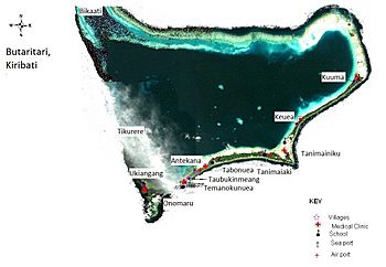
The southern and southeastern parts of the atoll have a nearly continuous line of islands. These are only broken by one wide section of reef between them. Most of these islands are between 0.2 and 0.5 kilometers wide. They get wider where the reef changes direction. You can find many mangrove swamps in these wider areas and along the southern lagoon shore.
The islets of Bikati and Bikatieta are at the far northwest tip of the atoll. They are next to a small lagoon north of the main lagoon. There's a village on the larger island of Bikati, which is about 2 kilometers long and 0.5 kilometers wide.
What are the Environmental Challenges?
One big worry for the islanders is saltwater seeping into the pits where they grow babai. Babai is a type of giant swamp taro, an important food. Problems with erosion (land wearing away) are linked to digging up sand and gravel, reclaiming land, and building causeways. Causeways are raised roads over water. These changes are thought to affect ocean currents along the shore.
The causeways have also made it harder for fresh ocean water to flow into the lagoon. This has led to low oxygen levels, which harms fish and causes other problems for marine life. Digging up sand and removing coral rocks also makes coastal erosion worse.
Butaritari's Villages
In 2010, Butaritari had a population of 4,346 people living in twelve villages:
| Kuuma | 323 inhabitants |
| Ukiangang | 707 inhabitants |
| Bikaati | 225 inhabitants |
| Tikurere | 8 inhabitants |
| Keuea | 258 inhabitants |
| Tanimainiku | 248 inhabitants |
| Tanimaiaki | 267 inhabitants |
| Tabonuea | 271 inhabitants |
| Antekana | 217 inhabitants |
| Taubukinmeang | 835 inhabitants |
| Temanokunuea | 621 inhabitants |
| Onomaru | 366 inhabitants |
Butaritari's Climate
Butaritari is one of the greenest islands in Kiribati because it gets a lot of rain. It usually receives about 4 meters of rain each year. This is much more than Tarawa Atoll (about 2 meters) or the far south of Kiribati (about 1 meter). Rainfall on Butaritari increases even more during an El Niño event.
Butaritari's Economy
Butaritari has rich ocean resources, with a large lagoon and a wide reef. It also has the best potential for farming in Kiribati. Fruits like bananas, breadfruit, and papaya grow well here. Farmers have also successfully grown pumpkins, cabbage, cucumbers, eggplant, and other vegetables. This has been possible with help from the Taiwan Technical Mission.
However, most families live a traditional lifestyle, growing their own food. Even though there's plenty of food, money is often hard to come by. This is because there are very few paid jobs on the island.
Butaritari's History
Ancient Stories and Legends
People tell different stories about how Butaritari and the other islands in the Southern Gilberts were created. One important legend in Butaritari's culture says that spirits lived in a tree in Samoa. They traveled north, carrying branches from this tree, called Te Kaintikuaba, which means "the tree of life." These spirits, along with a wise being named Nareau, created the islands of Tungaru (the Gilbert Islands).
From 1606 to 1899
The Spanish explorer Pedro Fernandes de Queirós saw the islands of Butaritari and Makin on July 8, 1606. He called them the Buen Viaje (Good Trip) Islands.
Traditionally, Butaritari and Makin were ruled by a chief called an Uea. This chief lived on Butaritari Island. The Uea had all the power to make decisions for both Butaritari and Makin. This was different from the southern Gilbert Islands, where a group of elders called unimwane shared power.
The people of Kuma village had a special power: they could call dolphins or whales! They used this ability for important feasts, like when a new meeting house (maneaba) was opened.
American explorers visited the islands in 1841. The United States later gave up any claims to Butaritari and Little Makin in the 1970s.
The first foreign traders arrived in the Gilberts in 1846. Butaritari became the main place for trade in the Gilbert Islands for a while. This was until a powerful trading company, Burns Philp, moved its operations to Tarawa, where the political leaders were.
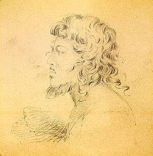
The famous writer Robert Louis Stevenson, his wife Fanny Vandegrift Stevenson, and his stepson Lloyd Osbourne visited Butaritari in 1889. At that time, Nakaeia was the ruler of Butaritari and Makin atolls. Stevenson described Nakaeia as a very strong and powerful ruler. Nakaeia allowed two American trading companies to operate, and up to 12 Europeans lived on the islands. Stevenson told people he was the son of Queen Victoria to make sure he was treated well.
The last Uea was Nauraura Nakoriri. He was in power before and after the Gilberts became a British Protectorate in 1892.
From 1900 to 1941
Butaritari Post Office opened on January 1, 1911. Japanese and other trading companies set up businesses in Butaritari Village during this time.
Butaritari in World War II
Japanese Arrival
On December 10, 1941, just three days after the attack on Pearl Harbor, about 300 Japanese soldiers arrived off Butaritari. They took control without any fighting. The Japanese called Butaritari "Makin." They wanted to use Makin as a base for seaplanes. This would help them patrol the Pacific Ocean and protect their eastern defenses from Allied attacks.
American Raid
In August 1942, Butaritari atoll was the site of the Makin Raid. Two groups of U.S. Marines landed from submarines. Their goal was to make the Japanese think the main attack would be there, drawing attention away from the planned invasion of the Solomon Islands. The Marines defeated the Japanese soldiers there, but they didn't manage to capture prisoners or gather much information.
American Invasion
Before the American invasion, there were 806 Japanese soldiers on Butaritari. However, most of them were workers, not trained combat troops. Only about 300 soldiers were ready for battle. The Japanese also had three tanks and three anti-tank guns.
Butaritari's defenses were mostly along the lagoon shore, near the seaplane base. The Japanese also built strong defense points on the ocean side. They thought the Americans would attack from there, based on the earlier raid. The Japanese defenders were outnumbered and outgunned. They could only try to slow down the American attack.
American air attacks started on November 13, 1943. Then, warships began firing at the island. On November 20, American troops landed. They fought their way through the Japanese defenses one by one. Even though the Americans had many more soldiers and weapons, it was hard to defeat the small Japanese force. On November 23, the American commander announced that "Makin taken."
About 395 Japanese and Korean soldiers were killed in the battle. The Americans lost 66 soldiers and had 152 wounded. However, on November 24, a Japanese submarine sank the American aircraft carrier USS Liscome Bay. When you include the 687 sailors who died on the carrier, the total American losses were more than the entire Japanese force on Makin.
Visiting Butaritari
You can fly to Butaritari! There's a twice-weekly air service connecting it with neighboring Makin and the capital, South Tarawa. This service is provided by Air Kiribati. The runway at Butaritari Atoll Airport was originally built by the Americans during World War II.
For a short time in 1995, there was an international flight route from Tarawa Atoll to Butaritari and then to Majuro. The idea was to help the island grow its economy and connect Kiribati with the Marshall Islands. Now, the only international flight connection is through South Tarawa. From there, Fiji Airways has a twice-weekly flight to Fiji.
Butaritari has three guesthouses. They offer basic places to stay, mostly for government workers and visitors. Tourists are also welcome!
Images for kids
See also
 In Spanish: Butaritari para niños
- USS Makin Island: A U.S. Navy ship named after the island.
- List of Guano Island claims
 | Victor J. Glover |
 | Yvonne Cagle |
 | Jeanette Epps |
 | Bernard A. Harris Jr. |


