
Caimito, San Juan, Puerto Rico facts for kids
Quick facts for kids
Caimito
|
||
|---|---|---|
.jpg)
Fireworks in Caimito on New Year's Eve 2014
|
||
|
||

Location of Caimito shown in yellow.
|
||
| Commonwealth | ||
| Municipality | ||
| Area | ||
| • Total | 5.41 sq mi (14.0 km2) | |
| • Land | 5.41 sq mi (14.0 km2) | |
| • Water | 0 sq mi (0 km2) | |
| Elevation | 322 ft (98 m) | |
| Population
(2020)
|
||
| • Total | 19,217 | |
| • Density | 3,552/sq mi (1,371.5/km2) | |
| 2020 census | ||
| Time zone | UTC−4 (AST) | |
.gif)
Caimito is one of the 18 main areas, called barrios, in the city of San Juan, Puerto Rico. It is located in the hilly part of the city. Caimito is the second largest barrio in San Juan. It covers about 5.41 square miles (14.0 km2) of land.
In 2010, Caimito had 21,825 people living there. This means about 4,034 people lived in each square mile. Caimito is in the southern part of San Juan. It shares borders with other barrios like Tortugo and Quebrada Arenas to the west. To the north is Monacillo, and to the east is Cupey. The city of Caguas is to the south.
Contents
History of Caimito
The name Caimito comes from the Caimito tree. This type of tree is very common in the area. The word caimito might be a Spanish version of the Taino word caima. The Taino people were the native people of the Caribbean.
Early Days in Caimito
In 1835, Caimito was made a suburb of Río Piedras. This was done by Pedro Tomás de Córdova, who was the leader of Puerto Rico at that time. Caimito was quite large, covering over 3,500 acres.
Caimito used to be two separate areas: Caimito Alto and Caimito Bajo. These two parts were last recorded together in a census in 1899. Caimito was part of Río Piedras until 1951. Then, it became a barrio of the bigger city of San Juan. A historian named Dr. Fernando Picó wrote a book about Caimito's history in 1989. It was called Vivir en Caimito, which means "Living in Caimito".
Local Leaders in the 1800s
During the 19th century, a person called the comisario de barrio was the main leader for Caimito. They represented the area to the Mayor of Río Piedras. These leaders were important because they helped manage local matters when the government was not always present. Most of them were not originally from Caimito. They were often business people or farmers who had moved there. This job did not pay much, but it gave them power and respect in the community.
List of Comisarios de Barrio in Caimito (19th Century)
| Name | Year |
|---|---|
| Vicente Viera | 1839 |
| Eusebio Noa | 1840 |
| Jose María Noa | 1842 |
| Ramón González | 1852 |
| Rafael Bigio | 1853 |
| Miguel Rodríguez | 1852 |
| Esteban Hernández | 1862 |
| Federico Pastrana | 1867 |
| Cecilio García | 1867 |
| Miguel Rodríguez | 1868 |
| José Perez | 1871 |
| Juan Noa | 1874 |
| Hilario Isaga | 1893 |
Geography of Caimito
Caimito is located in the mountainous part of San Juan. The highest point in San Juan is found here. It's an unnamed peak that is almost 1,030 feet (314 meters) above sea level. This peak is near the border with Caguas. It is also close to the Sendra Forest Park.
Some important rivers in San Juan start in this area. One is the Piedras River. This river gives its name to Río Piedras. It then flows into the Puerto Nuevo River and finally into the San Juan Bay.
Main Roads in Caimito
The main roads that go through Caimito include PR-199, PR-842, and PR-1.
-
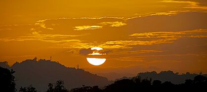
Sunset in Caimito (2014)
-
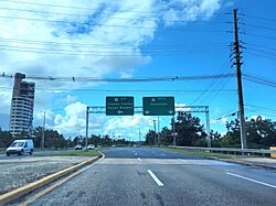
Puerto Rico Highway 199 in Caimito
-
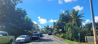
Puerto Rico Highway 842 in Caimito


Population of Caimito
| Historical population | |||
|---|---|---|---|
| Census | Pop. | %± | |
| 1900 | 1,706 | — | |
| 1910 | 1,934 | 13.4% | |
| 1920 | 2,329 | 20.4% | |
| 1930 | 2,884 | 23.8% | |
| 1940 | 3,115 | 8.0% | |
| 1950 | 4,588 | 47.3% | |
| 1960 | 6,987 | 52.3% | |
| 1970 | 13,268 | 89.9% | |
| 1980 | 15,939 | 20.1% | |
| 1990 | 19,413 | 21.8% | |
| 2000 | 20,832 | 7.3% | |
| 2010 | 21,825 | 4.8% | |
| 2020 | 19,217 | −11.9% | |
| U.S. Decennial Census 1899 (shown as 1900) 1910-1930 1930-1950 1980-2000 2010 2020 |
|||
In 2020, the population of Caimito was 19,217 people. Caimito is divided into smaller areas and neighborhoods. These include Camino Dr. Colorado, La Cuchilla, Camino Los Ramos, Morcelo, Camino Sánchez Guzmán, Camino Pablo Sánchez, Camino Los Sánchez, Camino Francisco Escribano, and Camino El Piloto.
Fun Places and Landmarks in Caimito
Caimito has several interesting places to visit.
- The Outlets at Montehiedra: This is a shopping mall that opened in 1994. It has over 100 stores, including popular ones like Home Depot, Marshall's, Nike, Old Navy, and Gap. It also has a large movie theater with fourteen screens, including IMAX and 4DX.
- Centro Zen de Puerto Rico: This is a Zen Center.
- Gimnasio Municipal de Caimito: This is a local gym.
- Centro Sor Isolina Ferré: This is a community center.
- Iglesia Episcopal San José: This is an Episcopal church.
Famous People from Caimito
Many notable people have connections to Caimito.
- Eduardo Bonilla-Silva: He is a professor of Sociology at Duke University. He was also the president of the American Sociological Association.
- Félix Trinidad: Known as "Tito" Trinidad, he is a famous former professional boxer. Even though he was born in Fajardo and grew up in Cupey, he is often linked to Caimito. This is because he trained at the Gimnasio Municipal de Caimito.
- Rubén Berrios: He is the president of the Puerto Rican Independence Party. He is also a professor at the University of Puerto Rico School of Law.
The Solis family, a well-known boxing family, also comes from Caimito.
- Enrique Solis: A boxer who fought for a world title.
- Julian Solís: A boxer who became a world champion.
- Rafael Solis: A boxer who also fought for a world title.
- Santos Solis: A professional boxer.
See also
 In Spanish: Caimito (San Juan) para niños
