
Calamba, Laguna facts for kids
Quick facts for kids
Calamba
|
|||
|---|---|---|---|
|
Component city
|
|||
| City of Calamba | |||
    (2018-08-21).jpg) From top, left to right: Calamba Giant Clay Pot, Jose Rizal Shrine, Mount Makiling, St. John the Baptist Parish Church, and Calamba City Hall.
|
|||
|
|||
Nicknames:
|
|||
| Motto(s):
Mabuhay ang Calamba!
("Long live Calamba!.") |
|||
| Anthem: "Calamba Hymn" | |||

Map of Laguna with Calamba highlighted
|
|||
|
OpenStreetMap
|
|||
.svg)
Calamba
Location in Philippines
|
|||
| Country | Philippines | ||
| Region | Calabarzon | ||
| Province | Laguna | ||
| District | [[{{#property:P7938}} | — Lua error in Module:Wd at line 1804: attempt to index field 'wikibase' (a nil value).]] | ||
| Founded | August 28, 1742 | ||
| Cityhood | April 21, 2001 | ||
| Barangays | 54 (see Barangays) | ||
| Government
|
|||
| • Type | Sangguniang Panlungsod | ||
| Area | |||
| • Total | 149.50 km2 (57.72 sq mi) | ||
| Highest elevation | 1,095 m (3,593 ft) | ||
| Lowest elevation | 2 m (7 ft) | ||
| Population
(2020 census)
|
|||
| • Total | 539,671 | ||
| • Rank | 20th | ||
| • Density | 3,609.84/km2 (9,349.4/sq mi) | ||
| • Households | 151,604 | ||
| Demonym(s) | Calambeño (Male), Calambeña (Female), Calambenean |
||
| Economy | |||
| • Income class | 1st city income class | ||
| • Poverty incidence |
|
||
| • Revenue | ₱ 5,910 million (2022) | ||
| • Assets | ₱ 18,585 million (2022) | ||
| • Expenditure | ₱ 5,211 million (2022) | ||
| • Liabilities | ₱ 6,103 million (2022) | ||
| Service provider | |||
| • Electricity | Manila Electric Company (Meralco) | ||
| • Water | Calamba Water District | ||
| Time zone | UTC+8 (PST) | ||
| ZIP code |
4027, 4028, 4029
|
||
| PSGC |
[https://psa.gov.ph/classification/psgc/?q=psgc/barangays/{{#pro000®code={{&provcode=
|
||
| IDD : area code | +63 (0)49 | ||
| Native languages | Tagalog | ||
| Patron saint | Saint John the Baptist | ||
| Website | www |
||

Calamba, officially known as the City of Calamba, is a busy city in the Laguna province of the Philippines. As of the 2024 census, it has a population of 575,046 people.
Calamba is an important center for the Calabarzon region. It is located about 50 kilometers south of Manila. The city is famous for its many hot spring resorts, earning it the nickname "Spring Resort Capital of the Philippines." These resorts are mostly found in areas like Pansol, Bucal, Bagong Kalsada, and Lingga.
In 2020, Calamba was the most populated city in Laguna. It is also one of the richest cities in the Calabarzon region because of its many businesses and factories. Calamba is also special because it is the hometown of José Rizal, the national hero of the Philippines.
Contents
City Name Origin
The name "Calamba" comes from the Tagalog word kalamba. This word means a large earthen water jar. You can see this origin reflected in the Calamba Jar landmark in the city's main plaza. The city's official seal also shows a water jar with a picture of José Rizal.
Calamba's Past
Early Beginnings
The oldest part of Calamba is thought to be Barangay Sucol, where the first settlers lived. When the Spanish arrived, the whole area became a large estate. It was once part of Tabuco, which is now Cabuyao. Calamba became its own independent town on August 28, 1742. Later, in 1813, the Dominican Brothers managed the land. They divided it and sold parts to local people during the American period.
World War II Impact
During World War II, the St. John the Baptist Church, built in 1859, was damaged. It was later rebuilt. This church is important because it is where José Rizal was baptized. The original baptismal font is still there today.
Becoming a City
Calamba officially became a city on April 21, 2001. This happened after a law, Republic Act No. 9024, was signed. The people of Calamba voted "Yes" to become a city in a special election. This change took more than seven years to complete.
The idea to make Calamba a city started in 1994. Local leaders worked hard to get a bill passed in the Senate of the Philippines and House of Representatives. In 2000, the process sped up. Finally, in 2001, the bill was approved and signed into law.
Regional Center Status
On October 28, 2003, Calamba was named the regional center of the Calabarzon region. This decision was made by the President at that time.
Where Calamba Is Located
.jpg)
Calamba is located on the northern side of Mount Makiling, which is a dormant volcano. It is a gateway to the southern provinces of Luzon because the South Luzon Expressway ends here. This highway connects Calamba to other towns in Laguna and to provinces like Batangas and Quezon.
The city shares borders with Cabuyao to the north and Los Baños to the east. To the west, it borders Cavite province, specifically Silang and Tagaytay. To the south, it borders Batangas province, including Tanauan and Santo Tomas. Laguna de Bay, the largest lake in the Philippines, forms the city's northeast border.
Calamba covers a total land area of about 14,950 hectares. This makes it the second-largest city in Laguna province by land area. The city's land is used for urban areas, agriculture, and conservation zones.
City Districts (Barangays)
Calamba is divided into 54 smaller areas called barangays. Each barangay has its own local leaders and helps manage the city.
Weather in Calamba
Calamba has a tropical monsoon climate. This means it has a short dry season and a long rainy season. The dry season is from January to April. The rest of the year sees a lot of rain.
| Climate data for Calamba (averages 1982–2012) | |||||||||||||
|---|---|---|---|---|---|---|---|---|---|---|---|---|---|
| Month | Jan | Feb | Mar | Apr | May | Jun | Jul | Aug | Sep | Oct | Nov | Dec | Year |
| Mean daily maximum °C (°F) | 29.3 (84.7) |
30.3 (86.5) |
31.9 (89.4) |
33.3 (91.9) |
33.5 (92.3) |
32.4 (90.3) |
31.4 (88.5) |
31 (88) |
31.1 (88.0) |
30.9 (87.6) |
30.3 (86.5) |
29.3 (84.7) |
31.2 (88.2) |
| Daily mean °C (°F) | 25.4 (77.7) |
25.9 (78.6) |
27 (81) |
28.5 (83.3) |
28.9 (84.0) |
28.2 (82.8) |
27.5 (81.5) |
27.3 (81.1) |
27.3 (81.1) |
27.1 (80.8) |
26.6 (79.9) |
25.7 (78.3) |
27.1 (80.8) |
| Mean daily minimum °C (°F) | 21.5 (70.7) |
21.5 (70.7) |
22.2 (72.0) |
23.5 (74.3) |
24.2 (75.6) |
24 (75) |
23.6 (74.5) |
23.6 (74.5) |
23.5 (74.3) |
23.3 (73.9) |
22.9 (73.2) |
22.2 (72.0) |
23.0 (73.4) |
| Average precipitation mm (inches) | 54 (2.1) |
26 (1.0) |
29 (1.1) |
36 (1.4) |
160 (6.3) |
199 (7.8) |
290 (11.4) |
265 (10.4) |
245 (9.6) |
248 (9.8) |
141 (5.6) |
79 (3.1) |
1,772 (69.6) |
| Source: Climate-data.org | |||||||||||||
People of Calamba
The population of Calamba has been growing quickly over the years.
According to the 2020 census, Calamba had 539,671 residents. This makes it the most populated city in Laguna province. Most people in Calamba are Roman Catholic.
City's Economy
|
||||
Calamba is known as the "Richest City in Calabarzon." This is because it has a high income from its many businesses. It is also considered one of the "Next Wave Cities" for outsourcing companies.
The main sources of income for Calamba come from factories, tourism, farming, and services. Many factories are located in areas like Canlubang, Real, and Milagrosa.
Banking Services
As of December 31, 2013, Calamba had 83 banking offices. These banks offer services to both businesses and residents. Calamba leads the Calabarzon region in total bank deposits.
Factories and Manufacturing

Calamba is a major industrial hub outside of Metro Manila. It is home to many industrial parks, including:
- Calamba Premiere International Park
- Canlubang Industrial Estate
- Carmelray Industrial Park 1 and 2
- Light Industry and Science Park of the Philippines II
Many well-known companies have their plants here. For example, Zenith Foods Corporation, which makes sauces and food products for Jollibee Foods Corporation, is located in Calamba. Other food companies like Rebisco and RC Cola also have plants here.
Several electronics companies, such as Samsung Electro-Mechanics Philippines and ST Microelectronics, operate in the city. Automobile manufacturers like Asian Transmission Corporation and Suzuki Philippines Inc. also have plants in Calamba.
Shopping and Trade


Besides the main "Crossing" area, Barangays Real and Parian are also busy business centers. You can find shopping malls like SM City Calamba and Checkpoint Mall there.
City Infrastructure
Getting Around (Transportation)

.jpg)
People in Calamba use Tricycles, buses, jeepneys, and UV Express to travel.
The city is also served by the Philippine National Railways (PNR) Metro Commuter Line. The main station is Calamba, located in the city proper.
Roads and Highways
The South Luzon Expressway (SLEX) is the main expressway in Calamba. It has four exits within the city. Other important roads include the Manila South Road and the Pan-Philippine Highway. The Calamba–Pagsanjan Road connects Calamba to Los Baños and Santa Cruz.
-
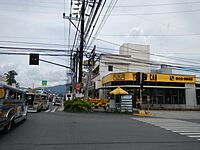
Stop Light in Halang
-
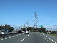
South Luzon Expressway (view from northbound) approaching Calamba Exit
-
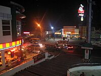
Checkpoint, captured at Paseo De Calamba in Paciano Rizal

.jpg)

Health Services

Calamba has several hospitals, including 9 private hospitals and 1 government-run hospital. Some of these are the Calamba Medical Center and Calamba Doctors' Hospital.
Utilities and Communication
Electricity in most of Calamba is provided by Meralco. All 54 barangays have electricity. The Calamba Water District supplies water to many homes and businesses. For communication, major telecom companies like PLDT and Globe Telecom offer phone and internet services.
City Government
Local Leadership
| City Mayor of Calamba, Laguna | |
|---|---|
 Roseller H. Rizal since June 30, 2022 |
|
| Style | (Mr.) Mayor, Mayor |
| Residence | New Calamba City Hall Building, Real, Calamba, Laguna |
| Appointer | Elected via popular vote |
| Term length | 3 years (maximum of three consecutive terms) |
| Inaugural holder | Mateo Elojorde |
| Formation | 1901 |
Like other cities in the Philippines, Calamba is led by a city mayor and a city vice mayor. They are elected for three-year terms. The mayor is in charge of running the city's departments. The vice mayor leads the city council, which has 14 members. This council creates the city's rules and policies.
Calamba now has its own special district for representation in the House of Representatives.
Elected Officials (2025–2028)
The local elections in Calamba in May 2025 chose the current city government leaders.
| Name | Party | ||
|---|---|---|---|
| House of Representatives | |||
| Charisse Anne C. Hernandez-Alcantara | Lakas | ||
| City Mayor | |||
| Roseller "Ross" H.Rizal | Lakas | ||
| City Vice Mayor | |||
| Angelito S. Lazaro, Jr. | Lakas | ||
| City Councilors | |||
| Soliman B. Lajara | PFP | ||
| Joselito G. Catindig | Lakas | ||
| Leeanne P. Aldabe-Cortez | Lakas | ||
| Doreen May F. Cabrera-Silva | Lakas | ||
| Gerard Raymund R. Teruel | Lakas | ||
| Maria Kathrina V. Silva-Evangelista | Lakas | ||
| Christian Niño S. Lajara | Lakas | ||
| Pursino C. Oruga | Lakas | ||
| Arvin L. Manguiat | Lakas | ||
| Pio C. Dimapilis | Lakas | ||
| Moises E. Morales | Lakas | ||
| Juan Carlo C. Lazaro | Lakas | ||
| Ex Officio City Council Members | |||
| ABC President | Eduardo R. Silva (La Mesa) | ||
| SK President | Rally R. Bustria (Barangay 5) | ||
City Seal Meaning

The official seal of Calamba has changed over time. It now shows what the city stands for.
- Shield shape: Represents strength and unity.
- Jar and Rizal's image: Shows the city's history, especially its connection to José Rizal and the kalamba jar.
- Numbers: "1742" is when Calamba became a town, and "2001" is when it became a city.
- Objects: The mountain in the background is Mount Makiling. The water represents Laguna de Bay. These show the city's natural resources. The rice field and industrial buildings show how Calamba balances nature with modern progress.
- Colors:
- Metallic gold: Represents the positive influence of Rizal and the jar.
- Red: Symbolizes the strong love for country, like Rizal's.
- Blue: Means wealth, growth, and peace.
- Silver grey: Shows the city's journey from a farming town to an industrial city.
- White: Stands for honesty and good governance.
The words "Lungsod ng Calamba" (City of Calamba) and "Laguna" show that it is a Philippine city and part of Laguna province.
Fun Things to Do (Tourism)
-
Calamba City Hall
-
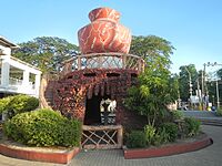
Calamba Claypot
-
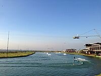
Republic Wakepark Canlubang
-
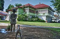
Rizal Shrine
-
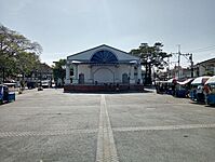
Calamba City Plaza
-
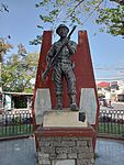
Calamba Veteran's Monument


.jpg)


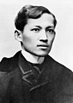
Calamba is a great place to visit! It is home to Rizal Shrine, the birthplace of José Rizal. You can also visit St. John the Baptist Parish Church, where Rizal was baptized.
The Rizal Park has a 22-foot tall statue of Rizal. The number 22 represents the languages Rizal used. The statue sits on a 15-step platform, symbolizing 15 decades since his birth. This monument was opened by President Benigno Aquino III in 2011.
Other cool places to see include the Calamba Claypot (also called Banga or Calambanga), which is a giant pot. There's also Republic Wakepark, a water sports park, and Calamba Island in Laguna de Bay. Because it's close to Mount Makiling, Calamba has many hot spring resorts, especially in Pansol and Bucal.
City Culture
Festivals and Celebrations
The Buhayani Festival is Calamba's official festival. It was started in 2013 by Mayor Justin Marc SB. Chipeco. The mayor wanted a festival that showed the city's culture and history. The name "Buhayani" combines two Filipino words: "buhay" (life) and "bayani" (hero).
The festival's motto is "Buhay ng Bayani, Buháy na Bayani." This means "Life of the Hero" (referring to Jose Rizal) and "Living Hero" (referring to everyday people who act like heroes). The festival aims to celebrate Rizal's life and inspire heroism in everyone.
The Buhayani Festival includes many activities. These include quiz bees about Rizal, football cups, street dancing, and a marching band competition. There are also events like "Hawig Rizal" (Rizal Look-Alike) and community missions. A special ceremony takes place at the Museo ni Rizal sa Calamba.
Learning in Calamba (Education)

Calamba has a very high literacy rate, meaning most people can read and write. As of 2007, there were 120 elementary schools and 50 secondary schools. The city also has 17 universities and colleges, plus 9 technical and vocational schools.
Several well-known schools have campuses in Calamba. These include Colegio de San Juan de Letran (Calamba Campus), Lyceum of the Philippines University (Laguna Campus), and University of Perpetual Help System DALTA (Calamba Campus). Other private schools like City College of Calamba and Don Bosco College, Canlubang are also here. In Nuvali Calamba, you can find Miriam College and Xavier School.
The City College of Calamba is the only public college in the city.
Famous People from Calamba
-
Dr. Jose Rizal
-

National Scientist Dolores Ramirez
-
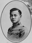
Vicente Lim
-

Jhoanna Robles
-
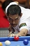
Ronato "Ronnie" Alcano


_at_West_Point_in_1914.png)
_(cropped).jpg)

- José Rizal – The national hero of the Philippines.
- Paciano Rizal – Jose Rizal's older brother and a general in the revolution.
- Trinidad Rizal – A leader who helped start the first women's organization in the Philippines.
- Delfina Herbosa de Natividad – One of the women who sewed the first Flag of the Philippines. She was Jose Rizal's niece.
- Vicente Lim – A Brigadier General during World War II.
- Leopoldo B. Uichanco – Known as the "Father of Philippine Entomology."
- Dolores Ramirez – A National Scientist of the Philippines for her work in genetics.
- Bienvenido O. Juliano – A National Scientist of the Philippines for his work in biochemistry.
- Jose Juliano – A nuclear physicist and chemist.
- José Yulo – A former Speaker of the Philippine House of Representatives and Chief Justice.
- Ruth Mariano-Hernandez – A former member of the House of Representatives.
- Dominador E. Chipeco, Sr. – A former Governor of Laguna.
- Teresita S. Lazaro – A former Governor of Laguna.
- Ramil L. Hernandez – The current Governor of Laguna.
- Ronnie Alcano – A professional pool player.
- Maybelline Masuda – A Brazilian Jiu-Jitsu athlete.
- John Vic De Guzman – A volleyball player and actor.
- Jerrold Tarog – A film director and screenwriter.
- Palito – A famous comedian and actor.
- Thea Tolentino – An actress.
- Jeric Gonzales – An actor.
- Sam Mangubat – A singer.
- Gigi De Lana – A singer-songwriter and actress.
- Jhoanna Robles – A member of the Pinoy pop group Bini.
Cities Calamba is Connected To (Sister Cities)
Local Connections
- Bacoor, Cavite
- Biñan, Laguna
- Cabuyao, Laguna
- Imus, Cavite
- Naga, Camarines Sur
International Connections
 Geumcheon (Seoul), South Korea
- Guri, South Korea
 Jinjiang, China
 Litoměřice, Czech Republic
 Walnut, United States
 Wilhelmsfeld, Germany
Images for kids
-
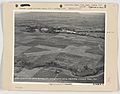
Aerial view of Calamba landing field, circa 1940s

See also
 In Spanish: Calambá para niños
