
Walnut, California facts for kids
Quick facts for kids
Walnut, California
|
|
|---|---|

View of Mt. San Antonio College and surrounding area
|
|

Location of Walnut in Los Angeles County, California
|
|

Walnut, California
Location in the United States
|
|
| Country | United States |
| State | California |
| County | Los Angeles |
| Incorporated (city) | January 19, 1959 |
| Named for | Rancho Los Nogales (lit. Ranch of the Walnut Trees) |
| Government | |
| • Type | Council-Manager |
| Area | |
| • Total | 9.00 sq mi (23.30 km2) |
| • Land | 8.99 sq mi (23.29 km2) |
| • Water | 0.00 sq mi (0.01 km2) 0.04% |
| Elevation | 561 ft (171 m) |
| Population
(2020)
|
|
| • Total | 28,430 |
| • Density | 3,301.4/sq mi (1,274.67/km2) |
| Time zone | UTC-8 (PST) |
| • Summer (DST) | UTC-7 (PDT) |
| ZIP Codes |
91788, 91789, 91795
|
| Area code(s) | 909, 626 |
| FIPS code | 06-83332 |
| GNIS feature IDs | 1652808, 2412173 |
Walnut is a city located in the eastern part of Los Angeles County in California. In 2010, about 29,172 people lived here. By 2019, the population was estimated to be around 29,685.
The area around Walnut is nestled between the steep San Jose Hills to the north and the gentle Puente Hills to the south. The city is known for its high-quality homes, which are part of carefully planned neighborhoods. Walnut also has an excellent public school system, the Walnut Valley Unified School District, which is considered one of the best in Southern California. Mt. San Antonio College is also located here.
Walnut covers almost 9 square miles (23 square kilometers) and is home to many businesses. In 2010, the average household income in Walnut was $101,250, making it one of the top-earning areas in the country.
The city's name comes from the old Mexican land grant called Rancho Los Nogales. Nogales is the Spanish word for "walnut trees." The native California black walnut tree is very common in the San Jose Hills. Walnut became an official city on January 19, 1959. It is run by a city council and a city manager. Five council members are chosen by the people, and they pick one of themselves to be mayor for a year. A city manager is hired to handle the city's daily tasks.
Contents
Exploring Walnut's Location and Weather
Walnut is situated on the southern slopes of the San Jose Hills. To the northwest is West Covina, to the north is Covina, and to the northeast is San Dimas. Pomona is to the east, while Diamond Bar, Rowland Heights, and the City of Industry are to the south. La Puente is to the west. Several small streams, like Snow Creek and Lemon Creek, flow south into the San Jose Creek valley, which then flows west into the San Gabriel River.
Walnut's Climate
Walnut has a warm climate. Here's a quick look at the weather:
| Climate data for Walnut, California | |||||||||||||
|---|---|---|---|---|---|---|---|---|---|---|---|---|---|
| Month | Jan | Feb | Mar | Apr | May | Jun | Jul | Aug | Sep | Oct | Nov | Dec | Year |
| Record high °F (°C) | 91 (33) |
94 (34) |
100 (38) |
104 (40) |
106 (41) |
117 (47) |
113 (45) |
109 (43) |
113 (45) |
107 (42) |
97 (36) |
93 (34) |
117 (47) |
| Mean daily maximum °F (°C) | 68 (20) |
69 (21) |
71 (22) |
76 (24) |
79 (26) |
84 (29) |
90 (32) |
92 (33) |
89 (32) |
80 (27) |
74 (23) |
68 (20) |
78 (26) |
| Mean daily minimum °F (°C) | 43 (6) |
45 (7) |
47 (8) |
49 (9) |
54 (12) |
58 (14) |
62 (17) |
62 (17) |
60 (16) |
55 (13) |
47 (8) |
42 (6) |
52 (11) |
| Record low °F (°C) | 21 (−6) |
22 (−6) |
27 (−3) |
29 (−2) |
31 (−1) |
38 (3) |
37 (3) |
43 (6) |
38 (3) |
29 (−2) |
25 (−4) |
22 (−6) |
21 (−6) |
| Average precipitation inches (mm) | 3.11 (79) |
4.76 (121) |
2.63 (67) |
1.20 (30) |
0.23 (5.8) |
0.09 (2.3) |
0.00 (0.00) |
0.03 (0.76) |
0.15 (3.8) |
1.05 (27) |
1.62 (41) |
2.45 (62) |
17.32 (440) |
Walnut's Rich History

The land where Walnut is today was originally home to the Tongva people. When Spanish missionaries arrived in the 1700s, they called these native people Gabrieleño. This was because the area was managed by the San Gabriel Mission. The Walnut area was part of the mission's network of ranches, used for grazing cattle and sheep.
After the missions were closed in the 1830s, the land was divided into large areas called ranchos. The Mexican government of Alta California gave these lands away. In the Walnut area, some of the first land grants were Rancho San Jose (given to Ricardo Vejar and Ygnacio Palomares in 1837), Rancho Los Nogales (given to Jose De La Cruz Linares in 1840), and Rancho La Puente (given to John Rowland and William Workman in 1842).
In 1868, John Rowland and William Workman split Rancho La Puente. Rowland received the eastern half, which included parts of modern-day Walnut and Rowland Heights. The land was mainly used for raising cattle and growing crops like wheat, grapes, and fruit trees, especially citrus.
In 1895, the first U.S. post office was opened in the area and was named "Lemon." In 1908, the post office's name was changed to Walnut. Today, the U.S. Post Office is still on Lemon Avenue, one of the city's main streets, reminding everyone of its early days.
The city of Walnut worked to preserve its history by building Lemon Creek Park and restoring the William R. Rowland Adobe Redwood Ranch House. This ranch house, built in 1883, was once the home of Mr. Meridith, who was the ranch foreman for Sheriff William Rowland. The adobe redwood ranch house is one of the few original ranch-style buildings left in the area. In 1975, it was added to the National Registry of Historical Places.
Walnut's Growing Population
| Historical population | |||
|---|---|---|---|
| Census | Pop. | %± | |
| 1960 | 934 | — | |
| 1970 | 5,992 | 541.5% | |
| 1980 | 12,478 | 108.2% | |
| 1990 | 29,105 | 133.3% | |
| 2000 | 30,004 | 3.1% | |
| 2010 | 29,172 | −2.8% | |
| 2019 (est.) | 29,685 | 1.8% | |
| U.S. Decennial Census | |||
What the 2010 Census Showed
The 2010 United States Census reported that Walnut had a population of 29,172 people. The city's population density was about 3,242.8 people per square mile.
The census also showed the different groups of people living in Walnut:
- 63.6% were Asian.
- 23.7% were White.
- 2.8% were African American.
- A small number were Native American or Pacific Islander.
- About 6.0% were from other races, and 3.5% were from two or more races.
- Overall, 19.1% of the people were Hispanic or Latino.
Most people in Walnut, about 99.9% of the population, lived in homes. There were 8,533 households in total. Many households (40.9%) had children under 18 living there. Most families (73.8%) were married couples. The average household had 3.41 people.
The population was spread out by age:
- 20.9% were under 18 years old.
- 10.6% were aged 18 to 24.
- 20.9% were aged 25 to 44.
- 35.4% were aged 45 to 64.
- 12.2% were 65 years or older.
The average age in Walnut was 43.1 years.
Most homes (88.3%) were owned by the people living in them, while 11.7% were rented.
Walnut's Economy and Jobs
Several companies have their main offices in Walnut. These include Shea Homes, the U.S. branch of the Filipino home video company Viva Video, Inc., and the Japanese card game company Bushiroad.
In 2010, the average household income in Walnut was $101,250. Only a small part of the population, about 6.2%, lived below the federal poverty line.
Here are some of the main employers in Walnut, based on a 2017 report:
| Rank | Employer | # of employees | % of total employment |
|---|---|---|---|
| 1 | Mount San Antonio College | 3,775 | 49% |
| 2 | Ninas Mexican Food, Inc. | 140 | 2% |
| 3 | Ronsin Photocopy Inc. | 124 | 2% |
| 4 | Recruiter Exchange Inc | 108 | 1% |
| 5 | Edro Engineering Company, Inc. | 84 | 1% |
| 6 | Stater Brothers Market | 81 | 1% |
| 7 | Sodexo, Inc. | 76 | 1% |
| 8 | Vons #2167 | 73 | 1% |
| 9 | Applebee's Neighborhood Grill | 67 | 1% |
| 10 | TJ Maxx #682 | 66 | 1% |
Fun and Culture in Walnut
Walnut hosts an annual event called the Walnut Family Festival. On the day of the festival, some streets like Lemon Avenue and La Puente Road are closed in the morning. A parade takes place with many local clubs and groups participating. Later in the afternoon, a fair is held at Suzanne Park, next to Suzanne Middle School. The fair has booths, games, food, and other fun activities. The Walnut Family Festival usually happens in early or mid-October.
Sports and Athletics in Walnut
The Famous Mt. SAC Relays

The Mt. SAC Relays started in 1959. They are a yearly track and field event held mainly at Hilmer Lodge Stadium on the Mt. San Antonio College campus. This festival, held in April, brings many top athletes from all over the world to Walnut. Other important track meets have also been held at this stadium, including the 1968 Olympic Trials. These events have made "Walnut, California" known for many national records in athletics around the world. Many world records have even been set at the Mt. SAC Relays over the years.
In October, the Mt. SAC Cross Country Invitational takes place in the hills around the stadium. It is said to be the largest Cross Country meeting in the world. Much of this course is also used for the yearly CIF Southern Section championships.
Proposed NFL Stadium Nearby
In April 2008, a wealthy land developer named Edward P. Roski shared plans to build a large NFL stadium in the nearby City of Industry. This stadium was planned to cost $800 million. In March 2009, Walnut filed a lawsuit against the stadium's construction, but they later dropped these charges in September.
On October 23, 2009, California's governor, Arnold Schwarzenegger, signed a bill. This bill allowed the 75,000-seat stadium to be built in the neighboring City of Industry. The hope was to attract an NFL team there. This bill also stopped a lawsuit filed by local residents about the project's environmental impact.
Education in Walnut
Most of the schools in Walnut are part of the excellent Walnut Valley Unified School District (WVUSD). This district is known as one of the best public school districts in Southern California. It also serves parts of Diamond Bar.
Schools located in and around Walnut include:
- C.J. Morris Elementary School
- Collegewood Elementary School
- Oswalt Academy (part of the Rowland Unified School District)
- Vejar Elementary School
- Walnut Elementary School
- Westhoff Elementary School
- Suzanne Middle School
- Southlands Christian Schools
- South Pointe Middle School
- Chaparral Middle School
- Ronald Hockwalt Academies
- Walnut High School
- Diamond Bar High School
Some areas on the western side of Walnut are also served by the Rowland Unified School District.
Additionally, Mt. San Antonio College, which is a community college, is located in Walnut, close to its border with Pomona.
City Services and Infrastructure
The Los Angeles County Sheriff's Department (LASD) has a station in Walnut that serves both Walnut and Diamond Bar.
The Los Angeles County Department of Health Services runs the Pomona Health Center in Pomona, which provides health services to people in Walnut.
Nearby Cities
Walnut is surrounded by these suburban cities:
- Diamond Bar, California (which shares the same school district with Walnut)
- City of Industry, California
- Pomona, California
Notable People from Walnut
- David Ji (born 1952), an electronics business owner who helped start Apex Digital.
- Aja Naomi King, an actress known for the TV show How to Get Away with Murder.
- Kyle MacKinnon, an ice hockey player who played for the San Diego Gulls.
- Darius McCrary, an actor, singer, and producer, famous for playing Eddie Winslow on Family Matters.
- Lance Parrish, a former professional baseball catcher in Major League Baseball.
Images for kids
-
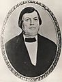
Californio rancher Ricardo Vejar owned land that is now part of Walnut.
-

The Olympic Flame and wall of honor at Hilmer Lodge Stadium
See also
 In Spanish: Walnut (California) para niños
