Rowland Heights, California facts for kids
Quick facts for kids
Rowland Heights, California
|
|
|---|---|

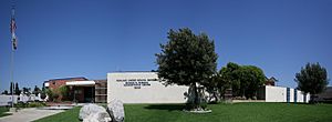
Rowland education district.
|
|

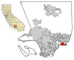
Location of Rowland Heights in Los Angeles County, California
|
|
| Country | |
| State | |
| County | |
| Named for | John A. Rowland |
| Area | |
| • Total | 13.082 sq mi (33.881 km2) |
| • Land | 13.076 sq mi (33.866 km2) |
| • Water | 0.006 sq mi (0.015 km2) 0.04% |
| Elevation | 525 ft (160 m) |
| Population
(2020)
|
|
| • Total | 48,231 |
| • Density | 3,686.82/sq mi (1,423.54/km2) |
| Time zone | UTC-8 (Pacific) |
| • Summer (DST) | UTC-7 (PDT) |
| ZIP code |
91748, 92821
|
| Area codes | 562, 626, and 909 |
| FIPS code | 06-63218 |
| GNIS feature ID | 1661344 |
| Website | RHCCC |
Rowland Heights is a community in Los Angeles County, California. It is located in the San Gabriel Valley, near the Puente Hills. In 2020, about 48,231 people lived there.
This area is part of the larger Los Angeles metropolitan area. It is the largest "census-designated place" (CDP) in Los Angeles County by size. A CDP is a special area defined for gathering statistics.
Rowland Heights is known for having many people from Taiwan. In the 1980s and 1990s, it was even called "Little Taipei." This was because many wealthy immigrants from Taiwan moved there.
Many companies like Newegg and FedEx are close by in the City of Industry. Because of this, many business owners and workers live in Rowland Heights. They also live in nearby places like Hacienda Heights and Walnut.
Rowland Heights is considered a very comfortable place to live. It ranks high for its summer weather, good schools, and overall environment.
Contents
Exploring the History of Rowland Heights

Early Days of the Rancho
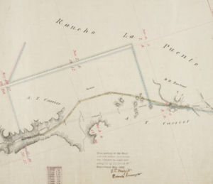
The land where Rowland Heights now sits was once part of a large Mexican land grant. This grant was called Rancho La Puente. In 1842, Governor Juan B. Alvarado gave about 18,000 acres to John A. Rowland.
A few years later, the grant grew to almost 49,000 acres. William Workman became a co-owner. In 1868, Rowland and Workman divided the land. Rowland received the northern, southern, and eastern parts. This included most of what is now Rowland Heights.
The Rowland family still owns some of this land today. They lease most of it for businesses.
How Rowland Heights Grew
Rowland Heights grew a lot in the 1990s. It was once a pig farm and then mostly orange groves. As Los Angeles grew eastward, more people moved here. Affordable homes were built for working-class families.
The 60 freeway also helped the community grow. New businesses and homes were built near the freeway. This growth has continued into the 21st century.
A Changing Community
Since the 1990s, many immigrants have moved to Rowland Heights. These include people from Taiwan, China, and South Korea. They often settled in the hillside homes. The area is advertised in China as having nice homes and good shopping.
Many of these new residents work in the nearby City of Industry. There are also many Latino families who have lived here for a long time.
Rowland Heights has become a mix of cultures. You can find "Chinatown", "Little Tokyo", and "Koreatown" areas. These are mostly in modern shopping centers. There are also many large Asian supermarkets.
The area is a big center for Chinese culture and business. Many Taiwanese people call it "Little Taipei." This is because of the many Taiwanese restaurants and businesses.
In 1992, a new road called Harbor Boulevard connected Rowland Heights to northern Orange County. This made Fullerton Road a very busy street.
In 2012, a huge 340-ton granite rock passed through Rowland Heights. It was on its way to the Los Angeles County Museum of Art. This rock was part of an art exhibit called Levitated Mass.
Where is Rowland Heights Located?
Rowland Heights is in Los Angeles County, California. It is right next to Orange County. The area defined by the Census Bureau helps track population data.
The community covers about 13.1 square miles (33.9 square kilometers).
Neighboring Communities
Rowland Heights shares borders with several other communities:
- To the northwest: Hacienda Heights
- To the east: Diamond Bar
- To the south: Brea
- To the southwest: La Habra Heights
- To the north: City of Industry
What is the Weather Like?
Rowland Heights has a warm-summer Mediterranean climate. This means it has warm, dry summers and mild, wet winters. It's often called "Csa" on climate maps.
Who Lives in Rowland Heights?
| Historical population | |||
|---|---|---|---|
| Census | Pop. | %± | |
| 1970 | 16,881 | — | |
| 1980 | 28,252 | 67.4% | |
| 1990 | 42,647 | 51.0% | |
| 2000 | 48,553 | 13.8% | |
| 2010 | 48,993 | 0.9% | |
| 2020 | 48,231 | −1.6% | |
| U.S. Decennial Census | |||
Rowland Heights is a census-designated place (CDP). This means the United States Census Bureau collects data about its population.
Population in 2010
In 2010, Rowland Heights had 48,993 people. The population density was about 3,745 people per square mile.
The community is very diverse:
- About 59.8% of people were Asian.
- About 23.5% were White.
- About 27.0% were Hispanic or Latino.
Most people (99.7%) lived in homes. There were 14,520 households. About 38.3% of these households had children under 18. The average household had 3.36 people.
The median age in Rowland Heights was 40.2 years old. This means half the people were younger than 40.2, and half were older.
Most homes (67.6%) were owned by the people living in them. The rest were rented. In 2018, the average home value was about $669,600.
The average household income in Rowland Heights was about $99,354. The median income was about $83,606. This is higher than the average for Los Angeles.
These were the ten neighborhoods in Los Angeles County with the largest percentage of Asian residents, according to the 2000 census:
- Chinatown, 70.6%
- Monterey Park, 61.1%
- Cerritos, 58.3%
- Walnut, 56.2%
- Rowland Heights, 51.7%
- San Gabriel, 48.9%
- Rosemead, 48.6%
- Alhambra, 47.2%
- San Marino, 46.8%
- Arcadia, 45.4%
Parks and Fun in Rowland Heights
Schabarum Regional Park
Peter F. Schabarum Regional Park is a popular spot. It's named after Peter F. Schabarum, who was a local government leader. The park has playgrounds and picnic areas. It also has trails for horseback riding in the nearby Puente Hills.
Cherry Blossom Festival
Schabarum Regional Park is famous for its beautiful cherry blossoms. In 1992, 500 plum blossom trees were given to the park from Japan. This was part of a "sister-park" relationship.
Community Library
The Los Angeles County Library runs the local library branch. It was updated in 2015 and reopened in 2018.
The library is large, with about 14,000 square feet of space. It has over 134,000 books. You can also find magazines, newspapers, and audio and video recordings. The library offers materials in many languages, including Chinese, Japanese, Korean, Spanish, and Vietnamese.
Learning in Rowland Heights
Rowland Unified School District serves Rowland Heights. It also serves parts of Walnut, La Puente, City of Industry, and West Covina. The district has over 16,000 students. It has 21 elementary and secondary schools.
Many schools in the district have won awards. These include National Blue Ribbon Schools and California Distinguished Schools.
High Schools
- Rowland High School (Grades 9-12)
- Nogales High School (Grades 9-12)
Alternative Schools
- Santana High School
- Rowland Unified Community Day School (Grades 7-12)
- Rowland Assistive Technology Academy
Middle Schools
- Alvarado Intermediate School (Grades 7-8)
- Giano Intermediate School (Grades 7-8)
- Rincon Intermediate School (now Telesis Academy)
Private Schools
- Oxford School (Grades 7-12)
- Southlands Christian Schools (Preschool-12)
Colleges Nearby
- Mount San Antonio College is located in Walnut. It serves high school graduates from the area.
Getting Around Rowland Heights
Main roads that go east and west include Pathfinder Road, Colima Road, and Gale Avenue. Main roads that go north and south include Nogales Street and Fullerton Road.
Public Transportation
You can use Foothill Transit and Metro buses to get around. The main Metro Bus Terminal is in El Monte.
The Metrolink train also runs nearby. It goes west to Downtown Los Angeles and east to San Bernardino. The closest station for Rowland Heights is Industry station.
Freeways
Several major freeways are close to Rowland Heights:
- San Bernardino Freeway (Interstate 10)
- Foothill Freeway (I-210)
- San Gabriel River Freeway (I-605)
- Long Beach Freeway (I-710)
- Orange Freeway (State Route 57)
- Pomona Freeway (State Route 60)
China Airlines offers private bus services from Rowland Heights to Los Angeles International Airport. This helps residents travel to Taipei, Taiwan.
Famous People from Rowland Heights
- Lanhee Chen (born 1995) - He worked as a policy advisor for presidential campaigns. He was also a member of the U.S. Social Security Advisory Board.
See also
 In Spanish: Rowland Heights para niños
 | Stephanie Wilson |
 | Charles Bolden |
 | Ronald McNair |
 | Frederick D. Gregory |


