Caloundra West, Queensland facts for kids
Quick facts for kids Caloundra WestCaloundra, Queensland |
|||||||||||||||
|---|---|---|---|---|---|---|---|---|---|---|---|---|---|---|---|

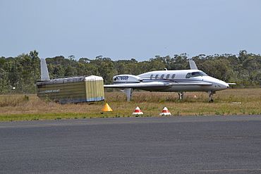
Beech Starship at Caloundra Airport
|
|||||||||||||||
| Population | 7,270 (2021 census) | ||||||||||||||
| • Density | 876/km2 (2,270/sq mi) | ||||||||||||||
| Postcode(s) | 4551 | ||||||||||||||
| Area | 8.3 km2 (3.2 sq mi) | ||||||||||||||
| Time zone | AEST (UTC+10:00) | ||||||||||||||
| Location |
|
||||||||||||||
| LGA(s) | Sunshine Coast Region | ||||||||||||||
| County | Canning | ||||||||||||||
| Parish | Bribie | ||||||||||||||
| State electorate(s) |
|
||||||||||||||
| Federal Division(s) | Fisher | ||||||||||||||
|
|||||||||||||||
Caloundra West is a suburb located in the Sunshine Coast Region of Queensland, Australia. It's a place where you'll find homes, businesses, and natural areas. In 2021, about 7,270 people called Caloundra West home. It's part of the larger Caloundra urban area.
Contents
Exploring Caloundra West's Geography
Caloundra West is situated just west of the main town area of Caloundra. It has a mix of different landscapes.
- The northern part of the suburb has houses, an industrial area, and undeveloped bushland.
- Right in the middle of Caloundra West, you'll find the Caloundra Airport.
- The western side of the suburb is mostly residential, meaning there are more homes there.
- To the south, there's undeveloped marshland, which is a type of wet, low-lying land.
- A main road called Caloundra Road runs through the suburb from west to east.
A Look at Caloundra West's History
The suburb of Caloundra West was officially named and given its boundaries on 18 June 1988.
The name Caloundra comes from the Kabi language, an Indigenous Australian language. The original word was Cullowundoor. It combines Kal Owen, which means beech tree, and Dha, which means place. So, Caloundra means "place of the beech tree."
A school called Unity College opened its doors in Caloundra West on 24 January 2006.
Who Lives in Caloundra West?
The number of people living in Caloundra West has been growing.
- In 2016, the suburb had a population of 6,297 people.
- By 2021, the population had increased to 7,270 people.
Learning in Caloundra West
Caloundra West is home to one main school.
- Unity College is a Catholic school that teaches students from Prep (the first year of primary school) all the way up to Year 12 (the last year of high school). It's located at 47 Lomond Crescent in the Bellvista Estate. In 2018, the school had 1,405 students.
There are no government-run schools directly in Caloundra West. However, students can attend government schools in nearby suburbs:
- Primary Schools: Talara Primary College in Currimundi, Meridan State College in Meridan Plains, Golden Beach State School in Golden Beach, and Baringa State Primary School in Baringa.
- Secondary Schools: Meridan State College in Meridan Plains and Caloundra State High School in Caloundra.
Important Places and Services
Caloundra West has some key facilities that serve the community.
- Caloundra Airport is an important local airport. You can find it on Pathfinder Drive.
- The Caloundra Fire Station is located at 18 Industrial Avenue. This is where firefighters are based to help keep the community safe.
Community Amenities
The suburb offers several amenities for its residents.
- The Sunshine Coast Regional Council provides a mobile library service. This special library on wheels visits Lomond Crescent in the Bellvista Estate, making it easy for people to borrow books.
- Caloundra West also has many parks where people can relax and play. Some of these include:
- Beau Vista Park
- Bellvista Neighbourhood Park
- Bimberi Circuit Park
- Dumbarton Drive Park
- Enterprise Road Reserve
- Exeter Way Park
- Isabel Jordan Bushland Reserve
- Rotary Park
- Sydal Street Park
Fun Things to See
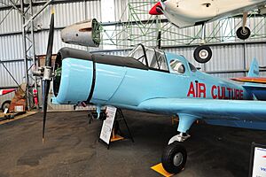
One of the main attractions in Caloundra West is a special museum.
- The Queensland Air Museum is located at Caloundra Airport on Pathfinder Drive. This museum is a great place to see many different types of airplanes and learn about the history of aviation.
 | Percy Lavon Julian |
 | Katherine Johnson |
 | George Washington Carver |
 | Annie Easley |


