
Camarillo, California facts for kids
Quick facts for kids
Camarillo, California
|
|||||
|---|---|---|---|---|---|
| City of Camarillo | |||||
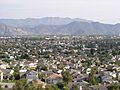
.jpg) .jpg)  Clockwise: California State University Channel Islands; view of Camarillo; St. Mary Magdalene Chapel
|
|||||
|
|||||
| Motto(s):
"Las Personas Son la Ciudad"
("The People Are the City") |
|||||

Location of Camarillo in Ventura County, California
|
|||||

Camarillo, California
Location in California

Camarillo, California
Location in the United States
|
|||||
| Country | United States | ||||
| State | California | ||||
| County | Ventura | ||||
| Rail station | 1898 | ||||
| Incorporated | October 22, 1964 | ||||
| Named for | Adolfo and Juan Camarillo | ||||
| Area | |||||
| • Total | 19.70 sq mi (51.03 km2) | ||||
| • Land | 19.69 sq mi (50.99 km2) | ||||
| • Water | 0.02 sq mi (0.04 km2) 0.08% | ||||
| Elevation | 177 ft (54 m) | ||||
| Population
(2020)
|
|||||
| • Total | 70,741 | ||||
| • Density | 3,593.47/sq mi (1,387.45/km2) | ||||
| Time zone | UTC−8 (PST) | ||||
| • Summer (DST) | UTC−7 (PDT) | ||||
| ZIP Codes |
93010–93012
|
||||
| Area code | 805 | ||||
| FIPS code | 06-10046 | ||||
| GNIS feature IDs | 1652682, 2409966 | ||||


Camarillo is a city in Ventura County, California. It is located in the U.S. state of California. In 2020, about 70,741 people lived there. This was an increase from 65,201 people in 2010. The city is named after two brothers, Juan and Adolfo Camarillo. They were important people who owned a large ranch called Rancho Calleguas and helped start the city. Today, California State University, Channel Islands is located on what used to be the Camarillo State Hospital.
Contents
History of Camarillo
Early Days and Native Americans
Thousands of years ago, the Chumash Indians lived in the area that is now Camarillo. Their main village was called Muwu, near today's Point Mugu. Another village, Simo'mo, was known for its saltbush. There are also caves with ancient drawings near Conejo Grade. These sites were used for religious ceremonies long ago.
How Camarillo Began

Camarillo is named after Californio brothers Adolfo Camarillo (pictured) and Juan Camarillo Jr., who founded the city on their Rancho Calleguas.
|
In the early 1800s, Mexico became independent from Spain. They started giving out large land grants in California. One of these grants created Rancho Calleguas in 1837. Later, Juan Camarillo bought this land. His sons, Adolfo and Juan, began to develop a ranch there. This ranch was in the fertile area known as the Oxnard Plain.
Growing into a Town
Around 1910, the first plans for the town of Camarillo were made. The town center was built around St. Mary Magdalen Church. This church was meant to be the family chapel for Adolfo Camarillo. In 1927, Juan Camarillo Jr. gave 100 acres (0.40 km2) of land for a seminary. This became St. John's Seminary, which opened in 1939.

Camarillo grew slowly until after World War II. The main business was farming, with many orange, lemon, and walnut groves. A large state hospital was the biggest employer. Traveling to Los Angeles was hard because of a winding road called the Conejo Grade.
Modern Growth and the Freeway
After the 1950s, the Ventura Freeway was finished. This made it much easier to travel to Camarillo from Los Angeles. The freeway cut through the old town. It also created the steep Conejo Grade descent from the Santa Monica Mountains. This grade is about 2.7 miles (4.3 km) long. The freeway helped Camarillo grow quickly. In 1962, the population was 7,500. Companies like 3M built facilities here, bringing many jobs.
Becoming a City

Camarillo officially became a city in 1964. This helped the city control its fast growth. Many people who moved to Camarillo in the 1960s were military veterans. They had been stationed at nearby bases like Naval Air Station Point Mugu and Naval Construction Battalion Center Port Hueneme. They liked the mild weather and peaceful living. Others moved for jobs with companies like 3M.
Camarillo Springs Fire
In May 2013, a large brush fire started in the Camarillo Springs area. It burned about 28,000 acres (11,000 ha) of land. Some houses were damaged, but none burned down. Rain helped firefighters put out the fire.
Geography and Climate
Where is Camarillo?
Camarillo covers about 19.5 square miles (50.5 km2). It is located in Pleasant Valley. To the north are the Santa Susana Mountains. To the east is the Conejo Valley. The Santa Monica Mountains are to the south.

Camarillo's Weather
Camarillo has a warm-summer Mediterranean climate. This means it has warm, dry summers. The winters are mild and wet. The average monthly temperatures are usually below 71.6°F (22°C).
| Climate data for Camarillo, California, 1991–2020 normals, extremes 1923–present | |||||||||||||
|---|---|---|---|---|---|---|---|---|---|---|---|---|---|
| Month | Jan | Feb | Mar | Apr | May | Jun | Jul | Aug | Sep | Oct | Nov | Dec | Year |
| Record high °F (°C) | 94 (34) |
91 (33) |
94 (34) |
100 (38) |
102 (39) |
102 (39) |
101 (38) |
97 (36) |
108 (42) |
108 (42) |
99 (37) |
94 (34) |
108 (42) |
| Mean maximum °F (°C) | 82.0 (27.8) |
81.4 (27.4) |
83.3 (28.5) |
86.5 (30.3) |
83.0 (28.3) |
81.5 (27.5) |
84.1 (28.9) |
85.6 (29.8) |
90.0 (32.2) |
92.9 (33.8) |
88.5 (31.4) |
80.6 (27.0) |
96.9 (36.1) |
| Mean daily maximum °F (°C) | 68.0 (20.0) |
67.6 (19.8) |
68.5 (20.3) |
71.0 (21.7) |
71.9 (22.2) |
74.7 (23.7) |
78.0 (25.6) |
79.5 (26.4) |
79.6 (26.4) |
76.4 (24.7) |
72.8 (22.7) |
67.7 (19.8) |
73.0 (22.8) |
| Daily mean °F (°C) | 56.5 (13.6) |
56.6 (13.7) |
58.0 (14.4) |
60.1 (15.6) |
62.3 (16.8) |
65.9 (18.8) |
69.1 (20.6) |
70.2 (21.2) |
69.5 (20.8) |
65.2 (18.4) |
60.7 (15.9) |
55.8 (13.2) |
62.5 (16.9) |
| Mean daily minimum °F (°C) | 45.0 (7.2) |
45.6 (7.6) |
47.4 (8.6) |
49.2 (9.6) |
52.7 (11.5) |
57.0 (13.9) |
60.3 (15.7) |
60.9 (16.1) |
59.4 (15.2) |
53.9 (12.2) |
48.6 (9.2) |
43.8 (6.6) |
52.0 (11.1) |
| Mean minimum °F (°C) | 36.2 (2.3) |
36.7 (2.6) |
39.1 (3.9) |
42.0 (5.6) |
47.0 (8.3) |
50.9 (10.5) |
54.5 (12.5) |
54.6 (12.6) |
52.2 (11.2) |
46.6 (8.1) |
39.5 (4.2) |
35.3 (1.8) |
33.9 (1.1) |
| Record low °F (°C) | 25 (−4) |
28 (−2) |
30 (−1) |
31 (−1) |
34 (1) |
37 (3) |
42 (6) |
43 (6) |
40 (4) |
35 (2) |
28 (−2) |
27 (−3) |
25 (−4) |
| Average precipitation inches (mm) | 2.85 (72) |
2.90 (74) |
2.00 (51) |
0.64 (16) |
0.33 (8.4) |
0.13 (3.3) |
0.02 (0.51) |
0.00 (0.00) |
0.06 (1.5) |
0.50 (13) |
0.87 (22) |
1.71 (43) |
12.01 (304.71) |
| Average precipitation days (≥ 0.01 in) | 5.6 | 6.6 | 5.2 | 2.8 | 1.6 | 0.4 | 0.2 | 0.3 | 1.1 | 2.7 | 4.0 | 5.5 | 36.0 |
| Source 1: NOAA | |||||||||||||
| Source 2: National Weather Service | |||||||||||||
People of Camarillo
Population Facts
| Historical population | |||
|---|---|---|---|
| Census | Pop. | %± | |
| 1960 | 2,359 | — | |
| 1970 | 19,219 | 714.7% | |
| 1980 | 37,797 | 96.7% | |
| 1990 | 52,303 | 38.4% | |
| 2000 | 57,077 | 9.1% | |
| 2010 | 65,201 | 14.2% | |
| 2020 | 70,741 | 8.5% | |
| U.S. Decennial Census | |||
In 2010, Camarillo had 65,201 people. Most people (75.1%) were White. About 10.2% were Asian, and 22.9% were Hispanic or Latino. The average household had about 2.64 people. The average family had about 3.14 people.
.jpg)
About 23.2% of the people were under 18 years old. The median age was 40.8 years. This means half the people were younger than 40.8 and half were older. Most people (69.8%) owned their homes.

Economy and Jobs

Several companies have their main offices in Camarillo, including Semtech and Salem Communications.
Top Employers in Camarillo
Here are some of the biggest employers in the city:
| # | Employer | # of Employees |
|---|---|---|
| 1 | Pleasant Valley School District | 729 |
| 2 | St. John's Hospital Camarillo | 611 |
| 3 | Meissner Filtration Products | 510 |
| 4 | Hi-Temp Insulation | 463 |
| 5 | Alert Communications | 421 |
| 6 | Teledyne Scientific & Imaging | 289 |
| 7 | Lucix Corp | 250 |
| 8 | Hygiena LLC | 204 |
| 9 | Mike's Farm Labor Contractor | 200 |
| 10 | Identity Management Services Org LLC | 189 |

Education in Camarillo
High Schools
Camarillo has three main public high schools. They are Adolfo Camarillo High School, Rio Mesa High School, and Rancho Campana High School. All of these schools are part of the Oxnard Union High School District.
California State University, Channel Islands
.jpg)
California State University, Channel Islands (CSUCI) is located in Camarillo. It opened in August 2002. The university is built on the grounds of the former Camarillo State Hospital. This hospital was a place where people could receive care. The university kept the special bell tower from the old hospital.
Parks and Fun Activities
The Pleasant Valley Recreation and Park District manages many parks and fun places in Camarillo.
Parks to Visit
- Adolfo Park
- Arneill Ranch Park
- Birchview Park
- Bob Kildee Community Park
- Calleguas Creek
- Camarillo Grove Park
- Carmenita Park
- Charter Oak Park
- Community Center Park
- Dos Caminos Park
- Encanto Park
- Foothill Park
- Freedom Park
- Heritage Park
- Laurelwood Park
- Eldred Lokker Memorial Park
- Mission Oaks Park
- Nancy Bush Park
- Pitts Ranch Park
- Pleasant Valley Fields
- Quito Park
- Springville Park
- Trailside Park
- Valle Lindo Park
- Woodcreek Park
- Woodside Park
Recreational Facilities
- Aquatic Center
- Auditorium
- Classrooms
- Community Center
- Dirt BMX Track
- Equestrian Center
- Freedom Center
- Freedom Gym
- Roller Hockey Rink
- R/C Track
- Senior Center
- Skatepark
Camarillo Christmas Parade
The Pleasant Valley Recreation and Park District has held the Camarillo Christmas Parade since 1962. This parade usually happens in early December. Many groups and thousands of people take part in the parade. People from all over come to watch it. Famous Grand Marshals have included Jessica Mendoza and Fernando Vargas.
City Services
Getting Around (Transportation)

You can get around Camarillo and nearby cities using buses operated by VCTC Intercity. The City of Camarillo also has a trolley that runs in the central area. There is also a bus line and Dial-A-Ride services for people with disabilities.
Camarillo Airport is a public airport west of the city. It is used for private planes and executive jets. It does not have regular commercial flights.
The Camarillo station is served by trains. Amtrak's Pacific Surfliner and Metrolink's Ventura County Line stop here. This connects Camarillo to places like San Luis Obispo and Los Angeles.
Water and Wastewater
Camarillo gets about 60% of its water from the state water project. The other 40% comes from local wells. A new facility called the North Pleasant Valley Desalter Project started working in 2023. It cleans salty well water to make it safe to drink.
The Camrosa Water District also provides water to parts of Camarillo. They have a desalting plant that cleans groundwater. The city also has a facility to treat wastewater.
Famous People from Camarillo
- Bryan Anger, NFL punter
- Bill Austin, football player
- Bob and Mike Bryan, professional tennis players
- Zach Charbonnet, football player for Seattle Seahawks
- Brandon Cruz, actor and musician
- Kaley Cuoco, actress, star of The Big Bang Theory
- Scott Fujita, football player
- Nat Gertler, writer, comics creator
- Ashley Johnson, actress
- Bobby Kimball, football player
- Charlie Kimball, Indycar driver
- Henry Koster, film director
- Jessica Mendoza, USA softball player and ESPN broadcaster
- Peggy Moran, actress
- Cyrus Nowrasteh, screenwriter and director
- Mike Parrott, MLB pitcher
- Duncan Renaldo, Western actor
- Marla Runyan, Paralympic gold medalist
- Robert A. Rushworth, USAF astronaut
- Jimmie Sherfy, Major League Baseball pitcher
- Emil Sitka, actor
- Jordan Sweeney, musician
- Jeff Tackett, Major League Baseball catcher
- Jason Wade, guitarist and vocalist of Lifehouse
- Trevor Wallace, comedian
- Patrick Warburton, actor, known for Seinfeld
- Delmon Young, Major League Baseball outfielder
- JoJo Romero Major League Baseball pitcher
Images for kids
-
View of Camarillo
See also
 In Spanish: Camarillo (California) para niños
