
Cambooya, Queensland facts for kids
Quick facts for kids CambooyaQueensland |
|||||||||||||||
|---|---|---|---|---|---|---|---|---|---|---|---|---|---|---|---|

Eton Street, 2014
|
|||||||||||||||

Cambooya
Location in Queensland
|
|||||||||||||||
| Population | 2,260 (2021 census) | ||||||||||||||
| • Density | 19.06/km2 (49.4/sq mi) | ||||||||||||||
| Postcode(s) | 4358 | ||||||||||||||
| Elevation | 465 m (1,526 ft) | ||||||||||||||
| Area | 118.6 km2 (45.8 sq mi) | ||||||||||||||
| Time zone | AEST (UTC+10:00) | ||||||||||||||
| Location |
|
||||||||||||||
| LGA(s) | Toowoomba Region | ||||||||||||||
| State electorate(s) | Condamine | ||||||||||||||
| Federal Division(s) | Groom | ||||||||||||||
|
|||||||||||||||
Cambooya is a small town and area in the Toowoomba Region of Queensland, Australia. It's a rural place, meaning it's mostly countryside with farms. In 2021, about 2,260 people lived in Cambooya.
Contents
Geography
Cambooya is in a part of Queensland called the Darling Downs. It is about 148 kilometers (92 miles) west of Brisbane, the capital city of Queensland.
The land around Cambooya is used for farming. Farmers grow crops both with and without extra water (irrigation). They also raise animals like cattle on grassy areas.
History


People from Europe first settled in this area around 1840. A man named Arthur Hodgson chose a large piece of land, about 65,000 acres, and called it Eton Vale.
In 1843, a government official surveyed the land. He set aside a spot for a town and named it Cambooya. No one is quite sure where the name came from. Some think it's an Aboriginal word like yambuya, meaning "tubers growing in a water hole". Others believe it means "egg", "skull", "reeds and rushes", or "many winds".
For a while, Cambooya was the main center for two big properties, Eton and Harrow. These were named after famous schools in England. Mr. Hodgson didn't want a town to grow there. So, nothing much happened until 1868. That's when the Cambooya railway station was built. This happened as the railway line was extended from Toowoomba to Warwick.
The Cambooya Post Office opened on March 12, 1869. It was located right at the railway station.
In 1877, some land from Eton Vale was taken to create smaller farms. This allowed more people to settle and farm in the area.
Schools in Cambooya
Cambooya Provisional School started on October 30, 1882. It had only 12 students from four local families. As more people moved to the area because of the railway, the school grew. A new building was put up in 1899 at the school's current location.
On January 1, 1909, it became Cambooya State School. A new state school building was built in 1910. The old provisional school building then became the teacher's house.
Other small schools opened nearby over the years, like Eton Vale Provisional School (around 1891) and Harrow State School (1909). These schools helped educate children in the wider Cambooya area. Nunkulla State School, which opened in 1912, closed in 1959. Its building was moved to Cambooya to become an extra classroom.
In 1985, a new school building was constructed. The school also got six plots of land, now called Johnson Oval. This oval is used for sports like cricket, soccer, and athletics. Cambooya State School celebrated its 125th birthday in 2007.
Community Buildings
The All Saints Anglican Church was officially opened on November 1, 1904. It was a beautiful church, but strong winds destroyed it in April 1914. The community worked together to raise money and rebuild it. The new church was dedicated on November 7, 1915.
The Cambooya Presbyterian Church opened on June 6, 1906. It was made of wood.
In October 1913, local Catholic families decided to build their own church. The Cambooya Catholic Church officially opened on November 9, 1914. It was designed by a famous architect named Harry Marks. In 1965, a new brick church was built next to the old wooden one.
In 1908, the post office, railway station, and goods shed were all destroyed in a fire. A new post office was built in 1909.
Dairy Farming
In the early 1900s, the Darling Downs region, including Cambooya, was well known for making cheese and other dairy products. Many towns had butter or cheese factories. At its busiest, in the late 1930s, there were 6,500 dairy farms and over 200,000 milking cows in the area.
War Memorial and Women's Association
The Cambooya War Memorial was unveiled on October 9, 1921. It honors those who served in wars.
In February 1923, a local group of the Queensland Country Women's Association (QCWA) was started in Cambooya. This group helps women in country areas. Ruth Fairfax, who founded the QCWA in Queensland, was elected as the first president of the Cambooya branch.
Demographics
In 2016, Cambooya had a population of 1,584 people. By 2021, the population had grown to 2,260 people.
Education
Cambooya State School is a government primary school for students from Prep (the first year of school) to Year 6. It is located on Harrow Street. In 2018, the school had 167 students.
There are no high schools in Cambooya itself. Students usually go to nearby towns for secondary school. The closest government high schools are in Toowoomba, Clifton, and Pittsworth.
Facilities
Cambooya has important facilities for the community:
- The Cambooya Police Station is on Quarry Street.
- The Cambooya SES (State Emergency Service) is on George Street. The SES helps people during emergencies like floods or storms.
- The Cambooya Post Office is on Eton Street.
Amenities
- The Toowoomba Regional Council provides library services with a mobile library van. It visits Cambooya State School every Friday.
- All Saints Anglican Church is on Eton Street.
- Sacred Heart Catholic Church is on Eton Street, with the older wooden church next to it.
- Cambooya Uniting Church is also on Eton Street.
Attractions
Cambooya has a famous old pub called the Bull and Barley. It's on Eton Street. It first opened in 1902 as the Cambooya Railway Hotel. It was once one of three pubs in town, but now it's the only one. The pub has even been shown on the TV show Getaway.
Across the road from the pub is the Cambooya War Memorial in Memorial Park. It's a tall stone monument, about 24 feet high. It has carvings of crossed rifles and marble plaques with the names of people who served in wars.
Notable people
Some famous people have lived in or near Cambooya:
- Steele Rudd (Arthur Hoey Davis): A well-known poet and writer.
- Ruth Fairfax: The founder of the Queensland Country Women's Association.
- Sir Arthur Hodgson KCMG: An early settler and important politician who helped develop the area.
Climate
| Climate data for Cambooya | |||||||||||||
|---|---|---|---|---|---|---|---|---|---|---|---|---|---|
| Month | Jan | Feb | Mar | Apr | May | Jun | Jul | Aug | Sep | Oct | Nov | Dec | Year |
| Record high °C (°F) | 41.0 (105.8) |
39.7 (103.5) |
35.6 (96.1) |
34.5 (94.1) |
29.4 (84.9) |
26.0 (78.8) |
26.5 (79.7) |
31.1 (88.0) |
33.5 (92.3) |
38.3 (100.9) |
39.4 (102.9) |
40.5 (104.9) |
41.0 (105.8) |
| Mean daily maximum °C (°F) | 30.1 (86.2) |
29.3 (84.7) |
27.9 (82.2) |
25.1 (77.2) |
21.4 (70.5) |
18.3 (64.9) |
17.7 (63.9) |
19.3 (66.7) |
22.6 (72.7) |
25.8 (78.4) |
28.5 (83.3) |
30.0 (86.0) |
24.7 (76.5) |
| Mean daily minimum °C (°F) | 16.3 (61.3) |
16.1 (61.0) |
14.3 (57.7) |
9.6 (49.3) |
5.7 (42.3) |
3.0 (37.4) |
2.0 (35.6) |
2.7 (36.9) |
5.9 (42.6) |
10.0 (50.0) |
13.0 (55.4) |
15.2 (59.4) |
9.5 (49.1) |
| Record low °C (°F) | 7.8 (46.0) |
4.4 (39.9) |
3.5 (38.3) |
−1.0 (30.2) |
−5.6 (21.9) |
−7.5 (18.5) |
−8.3 (17.1) |
−7.8 (18.0) |
−4.4 (24.1) |
−4.5 (23.9) |
1.9 (35.4) |
5.0 (41.0) |
−8.3 (17.1) |
| Average rainfall mm (inches) | 97.3 (3.83) |
80.5 (3.17) |
68.1 (2.68) |
42.2 (1.66) |
40.6 (1.60) |
40.9 (1.61) |
38.4 (1.51) |
31.2 (1.23) |
36.5 (1.44) |
64.3 (2.53) |
76.5 (3.01) |
100.6 (3.96) |
717.1 (28.23) |
| Average rainy days (≥ 0.2mm) | 8.5 | 7.9 | 7.6 | 5.4 | 5.6 | 5.9 | 5.7 | 5.1 | 5.2 | 7.1 | 7.9 | 8.7 | 80.6 |
| Source: Bureau of Meteorology | |||||||||||||
Images for kids
-
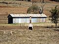
The ruins of Eton Vale Homestead, 2014.
-
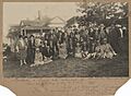
Women at a meeting of the Queensland Country Women's Association in Cambooya, 1927.


See also
 In Spanish: Cambooya para niños
