
Camel's Hump facts for kids
Quick facts for kids Camel's Hump |
|
|---|---|

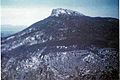
Camel's Hump, July 2006
|
|
| Highest point | |
| Elevation | 4,083 ft (1,244 m) |
| Prominence | 1,860 ft (570 m) |
| Listing | New England 4,000-footers New England Fifty Finest #46 |
| Geography | |

Camel's Hump
Location in Vermont
|
|
| Country | United States |
| State | Vermont |
| County | Chittenden / Washington |
| Town | Huntington / Duxbury |
| Parent range | Green Mountains |
| Geology | |
| Age of rock | 550 million years |
| Climbing | |
| Easiest route | Hiking trail |
| Designated: | 1968 |
Camel's Hump is a famous mountain in Vermont, a state in the United States. It's part of the Green Mountains range. The mountain is 4,083 feet (1,244 m) tall. This makes it one of the highest mountains in Vermont.
Camel's Hump has a special shape. It looks like a camel's back! This unique look makes it one of Vermont's most recognized mountains. You can even see it on the Vermont state quarter. The mountain is surrounded by a special area of alpine tundra. This is a cold, treeless area found at high elevations. Camel's Hump is a key part of Camel's Hump State Park.
Contents
What's in a Name?
People have called Camel's Hump by different names over time. These names usually describe its unique shape.
When Europeans first saw the mountain, probably in 1609, it was named "Le Lion Couchant." This French name means "The Resting Lion." Later, in 1798, a map called it "Camel's Rump." The name "Camel's Hump" started being used around 1830.
You might see the name written as "Camel's Hump" or "Camels Hump." Both are correct! The U.S. Board on Geographic Names usually avoids apostrophes in place names. But local people often use the apostrophe.
How the Mountain Was Formed
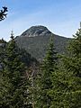
Camel's Hump stands out because of its shape. It looks like a cone, but it actually has two "humps." The southern hump is the taller one.
This mountain was shaped by glaciers. Glaciers are huge sheets of ice that move slowly. As they moved over the land, they carved out the mountain. This action gave Camel's Hump its distinctive look. The rocks that make up the mountain are mostly phyllite, quartzite, and schist.
In 1968, the National Park Service named Camel's Hump a National Natural Landmark. This means it's a very important natural area. They recognized it as a great example of how the Green Mountains were formed. This special landmark area covers about 5,300 acres (2,100 ha) around the mountain's top.
Amazing Plants and Trees

The very top of Camel's Hump has about 10 acres (4 ha) of alpine tundra plants. These are special plants that can live in cold, windy places. Some common plants you might see here are Bigelow's sedge, alpine bilberry, and crowberry.
These alpine plants used to grow in more places. But as the weather got warmer, they could only survive on the cold peak of Camel's Hump. There are 18 types of plants near the summit that are very rare. Five of these are protected by Vermont's endangered species rules.
The Green Mountain Club has a "Summit Caretaker" program. These caretakers teach hikers how to protect the fragile plants on the mountain. They help everyone follow "Leave No Trace" rules.
Even after a lot of logging in the late 1800s and a big fire in 1903, Camel's Hump still has many Red spruce trees. In the 1960s, scientists noticed that many red spruce trees were dying. They found that acid rain was causing the problem. Acid rain is pollution that makes rain acidic.
These discoveries helped raise public awareness. This led to changes in the Clean Air Act, a law that helps protect our air. By 2017, the red spruce trees were growing back. This showed that the problem of acid rain in the Northeast was mostly solved.
Mountain History

The Abenaki people, who lived in this area long ago, had their own name for the mountain. It was "ta wak be dee esso wadso." This name means things like "resting place" or "sit-down place."
In 1905, a kind person named Joseph Battell gave 1,200 acres (4.9 km2) of untouched forest, including the top of Camel's Hump, to the State of Vermont. He wanted it to be a state park kept in a "primitive state." This means it should stay wild and natural.
Since then, Vermont has passed laws to protect its natural areas. In 1969, they created a Forest Reserve around the mountain. Camel's Hump State Park has grown a lot. By 1991, it was about 20,000 acres (81 km2) big!
During World War II in October 1944, a B-24J bomber plane crashed into the side of the mountain. It was on a training mission. Most of the plane was taken away, but some parts, like a wing, are still there. The Alpine Trail passes by this crash site.
Camel's Hump is a popular place for hikers. The Green Mountain Club (GMC) started building trails here a long time ago. By 1912, a trail connected the mountain to Sterling Pond. This trail later became part of the "Long Trail," a famous hiking path.
The GMC now has caretakers who live near the summit in the summer. They teach hikers how to respect the fragile plants and environment on the mountain.
In 1999, an image of Camel's Hump was chosen for the Vermont state quarter. People thought it was perfect because it looks wild and natural, just like Vermont. It also seemed unique, like the independent spirit of Vermonters.
Camel's Hump is so well-known that its shape appears on the Vermont flag. Many local groups and even a children's radio show have used its memorable name.
Hiking Camel's Hump

Camel's Hump is often called Vermont's best peak for hiking. From the top, you can see amazing views all around. On a clear day, you might even see the highest peaks in New York, New Hampshire, and Vermont.
The two most popular places to start a hike are the Burrows Trailhead and the Monroe Trailhead. In 2016, almost 26,000 people signed the trail registers at these two spots!
Many trails lead to Camel's Hump. The Long Trail goes right over the summit. The Burrows Trail and the Monroe Trail connect to the Long Trail near the top.
From the Burrows Trailhead
The Burrows Trailhead is at the end of Camel's Hump Road in Huntington. It's about 1,800 ft or 550 m high. From here, you climb 2,283 feet (696 m) to reach the summit.
- Camel's Hump via the Burrows Trail: This trail goes up the west side of the mountain. It's 2.1 miles (3.4 km) long to where it meets the Long Trail. From there, it's another 0.3 miles (0.5 km) to the summit. The total one-way trip is 2.4 miles (3.9 km). This is the shortest and steepest way to the top. The Burrows Trail is the oldest trail on the mountain. It goes through some of the oldest spruce-fir forest. You can also use this trail for snowshoeing and skiing in winter.
- Camel's Hump via the Forest City Trail: This trail starts 0.1 miles (0.2 km) from the Burrows Trailhead. It's 1.4 miles (2.3 km) long to the Long Trail. From there, it's 1.9 miles (3.1 km) north to the summit. The total one-way trip is 3.4 miles (5.5 km). This trail follows an old logging road. It ends near the Montclair Glen Lodge, a shelter built in 1948.
From the Monroe Trailhead
The Monroe Trailhead is at the end of Camel's Hump Road in Duxbury. It's about 1,500 ft or 460 m high. From here, you climb 2,583 feet (787 m) to reach the summit.
- Camel's Hump via the Monroe Trail: This trail goes up the east side of the mountain. It's 3.1 miles (5.0 km) long to where it meets the Long Trail. From there, it's another 0.3 miles (0.5 km) to the summit. The total one-way trip is 3.4 miles (5.5 km). The Monroe Trail was built in 1912. It climbs through a large area of Mountain paper birch trees. These trees grew after the 1903 fire.
- Camel's Hump via the Dean Trail: This trail starts 1.3 miles (2.1 km) from the Monroe Trailhead. It's 1.0 mile (1.6 km) long to the Long Trail. From there, it's 1.7 miles (2.7 km) north to the summit. The total one-way trip is 4.0 miles (6.4 km). The Dean Trail crosses the Hump Brook Bridge. It also leads to the Hump Brook Tenting Area, where you can camp. You can see a beaver pond with views of Camel's Hump from this trail.
- Camel's Hump via the Alpine Trail: This trail starts 2.5 miles (4.0 km) from the Monroe Trailhead. It's 0.5 miles (0.8 km) long to the Long Trail. From there, it's another 0.2 miles (0.3 km) north to the summit. The total one-way trip is 3.2 miles (5.1 km). The Alpine Trail goes past the site of the 1944 plane crash. A B-24J bomber hit the mountain near the top.
From Duxbury Road
You can also start hiking from a parking lot on Duxbury Road. From here, the Long Trail climbs south for 2.7 miles (4.3 km). Then, a short path leads to the Bamforth Ridge Shelter. From the shelter, it's 3.5 miles (5.6 km) more to the summit. This one-way trip is 6.4 miles (10.3 km) long. It has a 3,683 feet (1,123 m) elevation change. This is the longest climb on the entire Long Trail!
Gallery
-
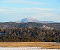
Western face of Camel's Hump Mountain from South Burlington, Vermont.
-
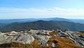
Southward view from the summit of Camel's Hump (with Mt. Ethan Allen in the immediate foreground), September 2017.
-
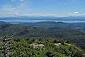
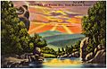
View east from old fire tower atop Poke-O-Moonshine Mountain in Chesterfield, NY: 2008
-
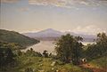
Painting of Camel's Hump by John Frederick Kensett, 1852, oil on canvas.
-
Eastern face of Camel's Hump taken in 1968
-
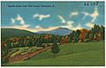
Postcard of eastern face of Camel's Hump
-
Postcard of western face of Camel's Hump
-
A view of Camel's Hump from the Allis Trail to the southeast


.jpg)
.jpg)

