
Carleton Island facts for kids

Carleton Island
Location in New York
Carleton Island (New York)
|
|
| Geography | |
|---|---|
| Location | St. Lawrence River at Cape Vincent, Jefferson County, New York |
| Coordinates | 44°10′43″N 76°17′17″W / 44.17861°N 76.28806°W |
| Area | 2.8 sq mi (7.3 km2) |
| Highest elevation | 331 ft (100.9 m) |
| Administration | |
|
New York
|
|
| County | Jefferson County |
| Demographics | |
| Population | 34 homes with 54 residents (2008) |
Carleton Island is a small island located in the St. Lawrence River in upstate New York. It's part of the town of Cape Vincent in Jefferson County. Today, the island is mostly used for fun activities like recreation and tourism.
Contents
Island History: From Ancient Times to Today
Carleton Island has a long and interesting history. It was first home to the Iroquois people. In 1720, a European explorer named Pierre François Xavier de Charlevoix noticed the island. He called it Isle aux Chevreuils, which means "Island of Roe Bucks." Later, it was also known as Isle a la Biche (Doe Island), Buck Island, or Deere Island.
The island was later renamed Carleton Island. It got its new name from Major General Sir Guy Carleton, who was the Governor of the Province of Quebec. This renaming was done by John Graves Simcoe, who also named other nearby islands after important figures from the Battle of the Plains of Abraham. These islands include Wolfe Island, Howe Island, Amherst Island, and Simcoe Island (formerly Gage Island).
Carleton Island During the American Revolution
During the American Revolutionary War, the British used Carleton Island as a very important military base.
- It was a place where military supplies were moved from one ship to another.
- It served as a naval station, meaning it was a base for British ships.
- Ships were built there to help the British forces.
- A fort called Fort Haldimand was built to protect the base and the shipyard.
- The island was also a starting point for attacks on American towns.
- People who supported the British, called Loyalists, found safety on the island from those who supported the American rebels.
After the war, the island was given to the Americans.
|
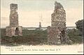
Fort Haldimand Site
|
|

Remains of Fort Haldimand, 1906
|
|
| Lua error in Module:Location_map at line 420: attempt to index field 'wikibase' (a nil value). | |
| Nearest city | Cape Vincent, New York |
|---|---|
| Area | 25 acres (10 ha) |
| Built | 1778 |
| Built by | Twiss, William |
| NRHP reference No. | 78001854 |
| Added to NRHP | December 15, 1978 |
Fort Haldimand: A British Stronghold
After the Seven Years' War, it was important for the British to control water routes in the Great Lakes for trade and travel. When the American Revolution began, securing these routes and having strong naval power on Lake Ontario became even more critical.
In 1778, Governor Frederick Haldimand ordered a search for the best place to build a naval station. Buck Island (Carleton Island) was chosen because it was easier to defend. The island became a key spot for moving supplies and the main base for British ships on Lake Ontario. Construction of Fort Haldimand began, though it was never fully finished.
Fort Haldimand, first called Fort Carleton, was very important for military strategy and shipbuilding. It was built in 1778 and named after General Frederick Haldimand. The fort was located on the southwest end of the island. It had strong walls, ditches, barracks (places for soldiers to live), and magazines (places to store ammunition). You can still see the ruins of the fort today on the southwest end of the island.
Several British army groups stayed at the fort. These included the Royal Artillery, the Royal Marines, Butler's Rangers, the King's Royal Regiment of New York, and the Royal Highland Emigrants.
There are three known burial grounds near the fort:
- Military burial grounds: About 25 burials are on the north side, outside the fort walls.
- Indian burial grounds: These are on the northwest shore near the fort.
- Civilian burial grounds: These are located east of the fort.
The Fort Haldimand Site is protected by the Thousand Islands Land Trust. It was added to the National Register of Historic Places in 1978.
Shipbuilding at Carleton Island
Near the fort, there's a spot called Government Point with two small bays.
- North Bay, also known as Schank's Harbor, was home to the Carleton Island Dockyard. This was a shipyard that operated from 1774 to 1792. It was likely named after John Schank, a British shipbuilder. A military dock was located at the southwest end of the bay.
- South Bay, or Government Harbor, was used by Royal Navy and Provincial Marine ships that served the fort until 1789.
Many ships for the war were built at the island, especially along the southeast shores of North Bay. One famous ship built here was the HMS Ontario, which was recently discovered. Other known ships built include:
- HMS Mississauga (1792) – a warship
- HMS Limnade (1780–81) – a warship
You can still see some sunken ships in North Bay near the old military dock. When Carleton Island was given to the Americans, the British moved their naval operations and shipbuilding to Kingston.
A Safe Place for Loyalists
Since Carleton Island was controlled by the British, many Loyalists who were trying to escape the American rebels came to the island. They built homes and started businesses there. One important businessman was Richard Cartwright, who later became a politician and judge. Another notable person who lived on Carleton Island and was loyal to the British was Molly Brant. She was the sister of Six Nations leader Joseph Brant.
After the Revolutionary War, when the island became part of the United States, many of these civilian residents moved to nearby Cataraqui (now Kingston, Ontario). Merchants and their warehouses were located northwest of the fort in an area called Merchant's Cove and Merchant's Point. Loyalist forces and Native Americans who supported the British used the island as a base to attack revolutionary forces. They participated in battles like Cherry Valley and Wyoming.

Carleton Island Becomes American
At the end of the American Revolutionary War, the Jay Treaty stated that the British would give Carleton Island and other forts to the Americans. However, the British didn't leave the forts right away.
Construction on Fort Haldimand stopped in 1783, and the post was finally abandoned in 1812. Today, the fort's ruins are just the outlines of its walls and a chimney from the barracks. The buildings were made of wood and have disappeared over time. Trees now cover the fort's remains.
During the War of 1812, Carleton Island was taken by three Americans without a fight, even though it was already supposed to be American territory. In 1817, New York State officially made the island part of Jefferson County. They gave 500 acres (2 km²) of land to Charles Smyth, the local postmaster.
The island had been a place for smugglers. Later that year, a Canadian tax collector tried to take some tobacco from the island. This caused a big argument, and New York's Governor DeWitt Clinton even threatened to fight. Eventually, Secretary of State John Quincy Adams had to help sort things out. After a lot of discussion, the island remained with the United States. It then became a place for farming (which is no longer done), sport-fishing, and summer tourism. No one lives on the island all year round.
Who Controlled Carleton Island?
Here's a quick look at who controlled Carleton Island over the years:
- New France (1720s–1763)
- Province of Quebec (British America and then British North America) (1778–1791)
- Upper Canada (British North America) (1792–1794)
- New York State (1817–present, though it was officially American territory from 1794 under the Jay Treaty)
The Wyckoff Villa
In the 1890s, a large mansion called Wyckoff Villa was built on the island. It was built by William O. Wyckoff, who was a sales agent for E. Remington and Sons and later started the Standard Typewriter Manufacturing Company.
The mansion was designed by William Henry Miller. It was a huge 15,000-square-foot (1,400 m²) house with 11 bedrooms. It combined two styles: Richardsonian Romanesque and Tudor Revival. Sadly, Wyckoff only lived in it for one day, as he died in 1895 shortly after moving in.
The property was briefly owned by General Electric, who planned to turn it into a company retreat. However, these plans were stopped during World War II. The mansion is now falling apart. Its windows and doors were removed during World War II, leaving it open to the weather. Both the stone foundation and the wooden upper floors have been damaged. Its tower has even collapsed. As of 2018, the mansion was for sale.
Carleton Island Today
Today, there are 34 homes on Carleton Island, mostly located along the shores. These homes are connected by dirt trails called Carleton Island Road 1 and Carleton Island Road 2, which residents use with ATVs.
On the southeast side of the island, two silos on one property have been turned into private homes that also work as observation towers. There are also several boat houses along South Bay.
The island used to have a ferry service that ran from the island to the village of Cape Vincent, but it's no longer running. Now, the only way to get to the island from the mainland or other nearby islands is by private boat. Most homes on the island have their own piers where residents can dock their boats.
Images for kids
-
Remains of Fort Haldimand, 1906
-
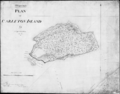
Map of Carleton Island, 1810
