
Cataño, Puerto Rico facts for kids
Quick facts for kids
Cataño
Municipio Autónomo de Cataño
|
|||
|---|---|---|---|
|
Town and Municipality
|
|||
|
Bacardi Cathedral of Rum
Blessed Martín de Porres Sanctuary
Taíno Monument
Cataño Ferry Terminal
San Juan Bay and Old San Juan from Cataño
|
|||
|
|||
| Nicknames:
"El Pueblo Que Se Negó a Morir", "La Antesala de la Capital", "El Pueblo Olvidado" "La Ciudad de un Nuevo Amanecer"
|
|||
| Anthem: "Cataño" | |||

Map of Puerto Rico highlighting Cataño Municipality
|
|||
| Sovereign state | United States | ||
| Commonwealth | |||
| Settled | late 17th century | ||
| Founded | July 1, 1927 | ||
| Named for | Hernando de Cataño | ||
| Barrios |
2 barrios
|
||
| Area | |||
| • Total | 7.04 sq mi (18.23 km2) | ||
| • Land | 4.8 sq mi (12.5 km2) | ||
| • Water | 2.21 sq mi (5.73 km2) | ||
| Population | |||
| • Total | 23,155 | ||
| • Rank | 54th in Puerto Rico | ||
| • Density | 3,289.7/sq mi (1,270.2/km2) | ||
| Demonym(s) | Catañese (neutral) | ||
| Time zone | UTC−4 (AST) | ||
| ZIP Codes |
00962, 00963
|
||
| Area code(s) | 787/939 | ||
| Major routes | |||


Cataño is a small but important town and municipality located on the northeastern coast of Puerto Rico. It sits just west of the capital city, San Juan, and is part of the larger San Juan metropolitan area. Cataño is known for being the smallest municipality in Puerto Rico by land area. It includes two main areas: Cataño barrio-pueblo (the downtown area) and Palmas.
Contents
History of Cataño: A Small Town's Journey
Cataño's story began with a doctor named Hernando de Cataño. In the late 1500s, he was chosen to provide medical help in Puerto Rico. As payment, he received a piece of land right across from the San Juan islet. People soon started calling this area "Cataño" after him.
Becoming a Part of Bayamón
As more people settled there, Cataño became a barrio (a type of neighborhood or district) of Bayamón. However, the area was quite swampy, which made it hard for the town to grow quickly. Around 1690, a small church was built so residents didn't have to travel far to Bayamón for religious services.
Growth and Independence
In the mid-1800s, a ferry service started. This ferry made it much easier to move goods and people across the San Juan Bay. This helped Cataño's population grow, making it one of Bayamón's busiest barrios. Even though they tried to become separate from Bayamón in 1839, it didn't happen until much later.
On June 26, 1893, Cataño, along with the barrios of Palo Seco and Palmas, got its own independent church. Finally, in 1927, Cataño officially became its own municipality. It was first called Hato de Palmas de Cataño, but over time, it was shortened to just Cataño.
Why Cataño Became Independent
Politics played a big role in Cataño becoming its own town. At the time, Bayamón was run by a group that disagreed with the island's main government. Making Cataño a separate municipality was a way to reduce the power of that opposing group.
Cataño's Small Size
Cataño is the smallest municipality in Puerto Rico, covering only about 12.5 square kilometers (about 4.8 square miles). This is less than half the size of the next smallest municipality, Hormigueros.
Hurricane María's Impact
On September 20, 2017, Hurricane María hit Puerto Rico very hard, and Cataño was no exception. The hurricane brought strong winds of 240 kilometers per hour (150 mph), destroying homes and flooding roads. About 650 homes were damaged or destroyed, and in the Juana Matos area, around 80% of homes were ruined.
Geography: Where is Cataño Located?
Cataño is mostly made up of flat land, typical of the northern part of Puerto Rico. Its northern edge touches the San Juan Bay and the Atlantic Ocean.
Bodies of Water in Cataño
Several important waterways are found in Cataño, including:
- Caño La Malaria (Malaria Channel)
- Río de Bayamón
- Río Hondo
Cataño's Barrios and Sectors

Cataño is divided into two main barrios: Cataño barrio-pueblo and Palmas. These barrios are then split into even smaller areas called sectores (sectors). These sectors can have different names like urbanización (urbanization), reparto (development), or residencial (residential area).
Special Communities in Cataño
Some areas in Puerto Rico are called Comunidades Especiales (Special Communities). These are communities where people might face challenges like social exclusion. In 2014, some of these special communities in Cataño included Cucharillas, Juana Matos, Puente Blanco, and Puntilla.
Culture and Fun in Cataño
Festivals and Events
Cataño celebrates its patron saint festival in July. This event, called Fiestas Patronales de Nuestra Sra. del Carmen, is a religious and cultural celebration. It usually includes parades, games, local crafts, amusement rides, traditional food, and live music.
Tourism: Places to Visit
Cataño has some great spots for visitors:
- The Boardwalk (El Malecón): This popular boardwalk offers amazing views of the San Juan Bay, including the historic Fort San Felipe del Morro across the water. You can also see several monuments and sculptures here, like the "India Taína" monument, which celebrates Taíno culture.
- Bacardi Distillery: The Bacardi Distillery is one of the world's largest rum makers. You can take a tour here to learn how rum is made and discover more about this important industry in the Caribbean.
.jpg)
The Christopher Columbus Statue
Cataño gained attention in 1998 when its mayor, Edwin Rivera Sierra, bought a huge statue of Christopher Columbus from Russia. This statue, called "Birth of the New World", was designed by artist Zurab Tsereteli. It was meant to be 350 feet (107 meters) tall! The artist had offered it to the United States in 1992, but it was not accepted.
Bringing the statue's 2,700 bronze pieces from Russia to Cataño cost $2.4 million. The pieces sat in a field for a long time because there wasn't enough money or public support to put it together in Cataño. Eventually, the statue was moved and set up in Arecibo.
Sports in Cataño
Cataño is home to several professional sports teams. It also has important sports facilities like the Perucho Cepeda Stadium, the Pedro Rodríguez Gaya Boxing Coliseum, and the Cosme Beitía Salamo Coliseum.
Economy: How Cataño Makes a Living
Because of its location on the coast, Cataño has always been an important port for the island. Fishing has also been a key part of its economy for hundreds of years.

One of the biggest businesses in Cataño is Bacardi, a famous rum company that has a large distillery there. Other industries in the town include refineries, trade companies, and transportation services.
Population and People of Cataño
| Historical population | |||
|---|---|---|---|
| Census | Pop. | %± | |
| 1930 | 8,504 | — | |
| 1940 | 9,719 | 14.3% | |
| 1950 | 19,865 | 104.4% | |
| 1960 | 25,208 | 26.9% | |
| 1970 | 26,459 | 5.0% | |
| 1980 | 26,243 | −0.8% | |
| 1990 | 34,587 | 31.8% | |
| 2000 | 30,071 | −13.1% | |
| 2010 | 28,140 | −6.4% | |
| 2020 | 23,155 | −17.7% | |
| U.S. Decennial Census 1930 1930–1950 1960–2000 2010 2020 |
|||
Even though Cataño is small in size, it has a large population, especially compared to other towns of similar land area. This is likely because it's so close to the capital, San Juan. In 2020, the population was 23,155.
Like most of Puerto Rico, Cataño's population is mainly made up of people with mixed European and African backgrounds, as well as those of European descent. There are also smaller groups of people with African and Asian heritage.
Symbols of Cataño
Cataño has its own official flag and coat of arms, which represent its history and identity.
The Flag of Cataño
The flag of Cataño has nine horizontal stripes: four blue and five white. A diagonal band of white and green crosses the flag from top to bottom. The green color stands for the palm trees, which are also seen on the coat of arms. This flag was officially adopted on September 5, 1974.
The Coat of Arms of Cataño
The coat of arms also features nine horizontal stripes, four blue and five silver. These colors come from the family crest of Don Hernando de Cataño, the person the town is named after. Silver represents nobility, and blue was used by noble families, symbolizing royalty and calmness.
Above the shield is a crown with three towers, which is a special design for this type of coat of arms. Two green palm trees surround the shield, reminding us of one of the town's original names: Hato de las Palmas de Cataño.
Cataño's Nicknames
Besides its official name, Cataño has several fun nicknames. It's known as "La Antesala de la Capital" (the Foyer of the Capital) because it's located right across the bay from San Juan. In the 1960s, people jokingly called it "Fanguito Town" (Muddy Town) because many of its streets were muddy, and some homes were built on stilts over wet areas.
Education in Cataño
Cataño has many public and private schools. These schools are managed by the Puerto Rico Department of Education.
Transportation: Getting Around Cataño
Puerto Rico Highway 22 is a main road that connects Cataño to San Juan and other nearby towns. Like most towns in Puerto Rico, Cataño has a public transportation system with shared public cars. Taxis are also available.
The Cataño Ferry

Cataño is famous for its ferry service, known as La Lancha de Cataño (the Ferry of Cataño). This ferry has been running since 1853! It offers a quick five-minute ride across the harbor between Cataño and Old San Juan. From the ferry, you can enjoy amazing views of the Castillo del Morro and the large cruise ships docked in Old San Juan. There are 16 bridges in Cataño that help people get around.
Images for kids
-
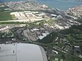
Aerial view of northeastern Cataño (upper left)
-
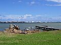
View of the San Juan Bay, Old San Juan, and Santurce from the Cataño shore
-
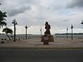
Monument to Taíno Culture, most commonly known as India Taína (Indian Taína)


See also
 In Spanish: Cataño para niños
