
Chadwell Heath facts for kids
Quick facts for kids Chadwell Heath |
|
|---|---|
 St Chad's Church |
|

Chadwell Heath
|
|
| Population | 24,278 (ward, 2011) |
| OS grid reference | TQ485885 |
| • Charing Cross | 12 mi (19 km) SW |
| London borough | |
| Ceremonial county | Greater London |
| Region | |
| Country | England |
| Sovereign state | United Kingdom |
| Post town | ROMFORD |
| Postcode district | RM6 |
| Post town | DAGENHAM |
| Postcode district | RM8 |
| Dialling code | 020 |
| Police | Metropolitan |
| Fire | London |
| Ambulance | London |
| EU Parliament | London |
| UK Parliament |
|
| London Assembly |
|
Chadwell Heath is a lively area in East London, England. It's part of both the London Borough of Barking and Dagenham and the London Borough of Redbridge. This area is about 2 miles (3 km) west of Romford and 4 miles (6 km) east of Ilford. It's also about 12 miles (19 km) north-east of Charing Cross, a famous spot in central London.
Contents
History of Chadwell Heath
What does the name 'Chadwell' mean?
The name 'Chadwell' was first written down in 1254. It was called Chaudewell, which means 'the cold spring'. This name first belonged to a small settlement near Barking. This place was also known as Chadwell Street. The word 'Street' here meant a small village or hamlet.
Later, in the 1600s, an area called Blackheath Common in Dagenham was renamed Chadwell Heath. As the two settlements grew closer, the name Chadwell Street was forgotten. Everyone started calling the whole area Chadwell Heath.
How did Chadwell Heath grow?
An old Roman road from London to Colchester passed through Chadwell Heath. This helped the area start to develop early on. For a long time, much of the area stayed as countryside.
In 1864, the Chadwell Heath Railway Station opened. This brought trains to the area. It also became the end of the line for London's tram system. Later, electric trolley buses also stopped here. These buses would turn around near Station Road.
Around 1900, more and more houses were built. This growth happened very quickly until World War I. After the war, even more homes were built.
Chadwell Heath during the World Wars
Chadwell Heath was affected by bombs during World War II. One large parachute mine exploded, causing a lot of damage to homes. It also destroyed a school. Another mine landed but did not explode. It was found by a train guard named Walter Wiffen. He reported it, and people living nearby were moved to safety.
A V2 rocket also hit Blackbush Avenue. It sadly killed several people and broke windows far away. Later, the local council replaced the damaged windows. Another V2 rocket destroyed two houses in Woodlands Avenue. It also damaged other houses that had just been fixed.
There was also a large anti-aircraft gun battery east of Whalebone Lane North. You can still see parts of its concrete foundations today.
Who lives in Chadwell Heath?
In 2011, a count of people (called a census) showed that Chadwell Heath had 24,278 residents. This count included people from both the Redbridge and Barking and Dagenham parts of the area.
Chadwell Heath is a very diverse place. No single ethnic group makes up the majority of people. The largest group is White British people. Other large groups include people from India, Black Africans, Black Caribbeans, Bangladeshis, and Pakistanis. Many other people from different backgrounds also live here.
Where is Chadwell Heath?
Chadwell Heath is split between two London Boroughs: Redbridge and Barking & Dagenham. Many important buildings, like the local school and the old police station, are in Redbridge.
The Royal Mail uses the postcode district RM6 for Chadwell Heath. The main post town for the area is Romford.
Chadwell Heath has three areas where people can grow their own plants. These are called allotments. One is next to St Chad's Park. Another is on Chadwell Heath Lane. The third is in Little Heath.
The main local school is Chadwell Heath Academy. There are also other large schools nearby. These include Mayfield School and Chadwell Heath Primary School.
How to get around Chadwell Heath
Chadwell Heath has good transport links. You can use London Buses to travel around. The Elizabeth Line also stops at Chadwell Heath Railway Station.
Many bus routes serve Chadwell Heath. These include routes 62, 86, 173, 362, and 368. There is also a night bus, the N86, for late-night travel.
The Eva Hart Public House

Eva Hart lived in Chadwell Heath for most of her life. She was famous for being one of the few people who survived the sinking of the Titanic. She sadly passed away in 1996.
The old police station building on High Road Chadwell Heath was turned into a pub. It was named "The Eva Hart" in her honor. You can still see the word "Police" on the building's top part.
St Chad's Park

St Chad's Park is the local park in Chadwell Heath. It's a large field, about a quarter of a square kilometer in size, with many trees around it. This park is the oldest in Barking and Dagenham. It was first created in 1830. The park also has an outdoor gym that anyone can use for free.
Embassy Cinema
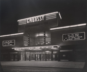
On Chadwell Heath High Road, there's an old cinema building. It has a special design style called Art Deco. It was built in May 1934 and was first called the Embassy Cinema. Later, it became part of the Gaumont British Circuit.
In the late 1960s, the cinema changed. It became a Bingo Hall, known to many as the Mecca Bingo Hall. In 2017, local residents worked to have the building listed as an Asset of Community Value. This means it's important to the community. Today, the building is an events center called Mayfair Venue.
Places of Worship
Chadwell Heath has several churches. The Roman Catholic Church of St Bede is on Bishops Avenue. St Chad's Church (part of the Church of England) is on St Chad's Road. There are also two Baptist churches in the area. Other churches include the United Reformed Church (URC) and the Brethren Assembly.
Sports in Chadwell Heath
West Ham United, a famous football club, used to have their training ground in Chadwell Heath. They moved to a new training ground nearby in Rush Green in late 2015.
Chadwell Heath is also home to St. Chad's Bowling Club. This club is for playing lawn bowls. In 2023, it became the only outdoor bowling club left in the London Borough of Barking and Dagenham. The club was started over 60 years ago and is located in St. Chad's Park.
Famous People from Chadwell Heath
Many interesting people have lived in or are from Chadwell Heath. Some of them include:
- Mary Wollstonecraft
- Henry Gillard Glindoni
- Eva Hart
- Millicent Martin
- Michelle Dockery
- Mark Summers
- Rhian Brewster
- Jackie Oliver
- Mark Lazarus
- Jim Peters (athlete)
- Nicky Shorey
- Victor Lewis-Smith
