Charity Shoal crater facts for kids
 |
|
| Impact crater/structure | |
|---|---|
| Confidence | Possible |
| Diameter | 1.2–1.4 kilometers (0.75–0.87 mi) |
| Age | Middle Ordovician |
| Exposed | Yes, on lake bottom, but covered with thin veneer of Ordovician limestone at water depths from 1–19.5 meters (3.3–64.0 ft) |
| Drilled | No |
| Location | |
| Coordinates | 44°2′15″N 76°29′37″W / 44.03750°N 76.49361°W |
| Country | Canada |
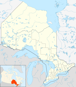
The Charity Shoal crater is a large, round shape found underwater. It is about 1.2–1.4 kilometers (0.75–0.87 mi) wide. This feature is located at the northeast end of Lake Ontario. It lies about 12 kilometers (7.5 mi) southwest of Wolfe Island. It's also about 25 kilometers (16 mi) south of Kingston, Ontario. Scientists believe it might be an impact crater from the Middle Ordovician period. This means it could have been formed by something hitting Earth a very long time ago.
Contents
Discovering the Charity Shoal Crater
The Charity Shoal area has been known for a long time.
- On December 5, 1897, a steamship called the Rosedale got stuck on rocks there.
- In 1900, John C. Churchill, Jr. surveyed the area. He helped map the outlying spur known as East Charity Shoal.
The crater itself was first mapped in detail much later. This was part of a larger map of Lake Ontario. Different groups worked together on this map. These included the National Oceanic and Atmospheric Administration (NOAA) and the Canadian Hydrographic Service.
In 2001, based on these maps, scientists first suggested it was an impact crater. More detailed studies happened in 2010 and 2011. High-resolution underwater mapping data was collected. This helped create a very detailed 3D model of the lake bottom. In 2012, even more surveys were done. These included magnetic surveys over the Charity Shoal area.
What the Crater Looks Like
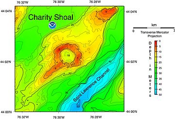
The Charity Shoal Crater is like a small, oval-shaped bowl. It has a circular rim. This rim is about 1.2–1.5 kilometers (0.75–0.93 mi) across. The water depth on the rim varies. It can be less than 1 meter deep near the Charity Shoal Lighthouse. At its lowest point, it's just over 10 meters (33 ft) deep.
The outside slopes of the rim are not as steep as the inside slopes. Some valleys cut across the southwestern part of the rim. The bottom of the crater is slightly oval. It is about 1 kilometer (0.62 mi) long and 0.8 kilometers (0.50 mi) wide. The deepest part of this basin is 18–19.5 meters (59–64 ft) deep. A small rise, about 2–3 meters (6.6–9.8 ft) high, divides the crater floor. This creates two smaller dips inside.
A long, thin ridge stretches out from the crater. It goes about 3–4 kilometers (1.9–2.5 mi) southwest. This ridge makes the crater look a bit like a frying pan. At its shallowest, this ridge is less than 6 meters (20 ft) below the lake surface. Other smaller ridges run parallel to this main one. They are found at depths of 18–19.5 meters (59–64 ft). Many other linear features also cut across the crater and the lake bottom.
The crater and its ridge sit on a larger, flat-topped ridge. This bigger ridge is one of several in the area. These ridges are found between Main Duck and Wolfe Islands. They are also northwest of the deep Saint Lawrence Channel. The bottom of Lake Ontario in this area has been shaped by ancient glaciers. These glaciers created many long, parallel lines and features.
What the Surface is Made Of
The surface of the Charity Shoal Crater is a mix of different materials. You can find solid bedrock, broken bedrock, and lake sediments. The rim of the crater is made of eroded bedrock. It also has patches of broken bedrock. The inside and outside slopes of the crater are covered with broken rocks.
Scientists found loose rocks from the crater rim. These rocks were mostly sandstone, quartzite, and gneiss. These are glacial erratics. This means they were carried here by glaciers from other places. They came from older rocks like Precambrian, Cambrian, and Ordovician layers. Some rocks found were fossiliferous limestone. These are thought to be from the local bedrock. However, no signs of shatter cones or breccia were found. These are special rocks that often form during impacts.
The inside of the crater is filled with stiff, varved clay. This clay has layers that show seasonal changes. On top of the clay is a layer of coarse brown sand. It's about 1–2 cm (0.39–0.79 in) thick. Underneath, there are up to 10–12 meters (33–39 ft) of loose sediments. These sediments lie on top of Ordovician limestones. The top 2–3 meters (6.6–9.8 ft) of the crater fill are layered muds and silt. Below that, there's a unit of poorly-layered sediment. This likely consists of sand and gravel. The very bottom of the crater fill is a bedrock surface. It's only 20 meters (66 ft) below the top of the crater's rim.
The ridge that extends southwest from the crater is made of bedrock. It's covered with sandy gravel. This looks like a medial moraine, which is a ridge formed by glaciers. This ridge and other features show that glaciers greatly changed the bottom of Lake Ontario.
Rocks Under the Surface
The bottom of Lake Ontario, where the crater is, is made of Middle Ordovician limestone. These rocks are part of the Trenton Group. They are hard and resist erosion. They also tilt gently to the southwest. These limestone layers are hundreds of meters thick.
Underneath these Ordovician rocks are thin Cambrian sandstones. These sandstones rest on even older rocks. These are Late Proterozoic basement rocks. They are part of the Frontenac Terrane. They likely include hard rocks like gneisses, marble, and quartzite.
Special sonar data was collected in 2010 and 2011. It showed that the crater's rim is made of undisturbed bedrock. This bedrock has been almost completely cleared of sediments by erosion. The sonar data also showed small ridges on the bedrock. These ridges are less than 1 meter (3.3 ft) high. They are spaced about 15 meters (49 ft) apart. These micro-ridges follow the shape of the rim. They also dip away from the rim. This suggests a continuous ring-shaped fold in the rock, called an anticline. This ring anticline is about 2.1–2.5 kilometers (1.3–1.6 mi) across. It matches the crater rim. The rock layers here are gently tilted. They don't show signs of being flipped over or standing straight up.
Why Scientists Think It's a Crater
Scientists haven't found direct proof of shock metamorphism yet. This is a type of change in rocks caused by extreme pressure, like from an impact. This is probably because samples haven't been taken from deep enough. To confirm it's an impact crater, scientists would need to drill into the rocks. They would need to collect core samples from underneath the limestone layers.
However, there are strong reasons to believe it's an impact crater.
- The circular shape of the crater is a key clue.
- There's no sign of volcanoes in the area.
- Geophysical surveys show unusual patterns.
One scientist, Philip Suttak, studied magnetic data. His models suggest the Charity Shoal Crater is not just a glacial feature or a sinkhole. The data fits best with an impact crater. It could be about 450–600 meters (1,480–1,970 ft) deep.
The ridge extending from the crater is likely a till ridge. Or it could be a crag-and-tail feature. These are common in areas shaped by glaciers. This ridge probably formed under the Laurentide Ice Sheet. This ice sheet flowed southwest during the last glaciation. Other features on the lake bottom also show that glaciers greatly changed this area.
How Old is the Crater?
Scientists believe the Charity Shoal Crater formed in the Middle Ordovician period. This means it's very old. The crater has been significantly changed by glaciers. This shows it was there before the last major advance of the Laurentide Ice Sheet.
The rim of the crater is covered by Middle Ordovician limestone. This means the crater must be at least as old as these rocks. Also, the crater's rim is much lower than what models predict for an impact crater. This suggests that the central part of the crater filled with sediments after it formed. This filling reduced its original depth.
 | Shirley Ann Jackson |
 | Garett Morgan |
 | J. Ernest Wilkins Jr. |
 | Elijah McCoy |


