Chatham, New York facts for kids
Quick facts for kids
Chatham, New York
|
|
|---|---|

Old Chatham
|
|

Location of Chatham, New York
|
|
| Country | United States |
| State | New York |
| County | Columbia |
| Established | 1795 |
| Government | |
| • Type | Town Council |
| Area | |
| • Total | 53.54 sq mi (138.68 km2) |
| • Land | 53.23 sq mi (137.86 km2) |
| • Water | 0.32 sq mi (0.82 km2) |
| Elevation | 239 ft (73 m) |
| Population
(2020)
|
|
| • Total | 4,104 |
| • Density | 76.653/sq mi (29.593/km2) |
| Time zone | UTC-5 (Eastern (EST)) |
| • Summer (DST) | UTC-4 (EDT) |
| ZIP code |
12037
|
| Area code(s) | 518 |
| FIPS code | 36-021-14014 |
| GNIS feature ID | 0978814 |
Chatham (pronounced CHAT-uhm) is a town in Columbia County, New York, United States. In 2020, about 4,104 people lived there. This number was a little lower than in 2010.
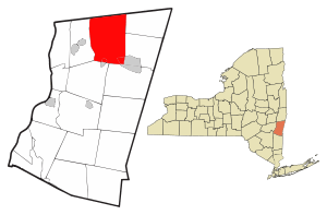
A smaller area called the Village of Chatham is also part of the town. It sits on the southern border of the town. Chatham is located at the northern edge of Columbia County.
Contents
History of Chatham
The first people to settle in Chatham were from the Netherlands. Later, Quakers and people from New England moved there. The town of Chatham was officially created in 1795. It was formed from parts of two other towns: Canaan and Kinderhook.
In the early 1900s, Chatham was a busy place for industry. It was a major hub for many train lines that connected different states. Trains from the Boston and Albany Railroad went east and west. The Rutland Railroad connected Chatham to Vermont in the north. The New York Central's Harlem Line offered trips to New York City. A special train station, designed by Henry Hobson Richardson, was built in 1887. Today, Amtrak trains still pass through Chatham, but they don't stop there. However, there are plans to build a new Amtrak station in Chatham in the future.
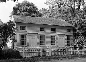
Several historic buildings and areas in Chatham are listed on the National Register of Historic Places. This means they are important and protected. Some of these include the Blinn-Pulver Farmhouse, Melius-Bentley House, Peck House, and Simons General Store.
Geography of Chatham
Chatham covers a total area of about 138.7 square kilometers (53.5 square miles). Most of this area, about 137.9 square kilometers (53.2 square miles), is land. The rest, about 0.8 square kilometers (0.3 square miles), is water.
The northern border of Chatham is also the border of Rensselaer County.
Important roads like the Taconic State Parkway and Interstate 90 go through the town. Also, New York State Route 66 and New York State Route 203 meet in Chatham.
Towns Near Chatham
Chatham is surrounded by several other towns:
- To the west is the town of Kinderhook.
- To the east are the towns of Canaan and New Lebanon.
- To the north, in Rensselaer County, are Schodack and Nassau.
- To the south are Austerlitz and Ghent.
Population of Chatham
| Historical population | |||
|---|---|---|---|
| Census | Pop. | %± | |
| 1820 | 3,372 | — | |
| 1830 | 3,538 | 4.9% | |
| 1840 | 3,662 | 3.5% | |
| 1850 | 3,839 | 4.8% | |
| 1860 | 4,163 | 8.4% | |
| 1870 | 4,372 | 5.0% | |
| 1880 | 4,574 | 4.6% | |
| 1890 | 4,019 | −12.1% | |
| 1900 | 3,537 | −12.0% | |
| 1910 | 3,396 | −4.0% | |
| 1920 | 2,705 | −20.3% | |
| 1930 | 2,908 | 7.5% | |
| 1940 | 2,873 | −1.2% | |
| 1950 | 3,188 | 11.0% | |
| 1960 | 3,402 | 6.7% | |
| 1970 | 3,770 | 10.8% | |
| 1980 | 4,294 | 13.9% | |
| 1990 | 4,413 | 2.8% | |
| 2000 | 4,249 | −3.7% | |
| 2010 | 4,128 | −2.8% | |
| 2020 | 4,104 | −0.6% | |
| U.S. Decennial Census | |||
In 2000, there were 4,249 people living in Chatham. The town had 1,762 households. The average age of people in Chatham was 43 years old. About 23.5% of the population was under 18 years old.
Places in Chatham
The town of Chatham includes several smaller communities and locations:
- Village of Chatham – This village is partly in the town, near its southern border.
- Chatham Center – A small community located west of the town's center.
- East Chatham – A community located at the eastern edge of the town.
- Kinderhook Lake – A lake that is partly within the town, near its western border.
- Malden Bridge – A community in the northern part of the town.
- New Concord – A community near the eastern town line.
- North Chatham – A community in the northwestern corner of the town. The Peck House is a historic site here.
- Old Chatham – One of the oldest settlements in the town, located northeast of the town's center.
- Rayville – A community in the northeastern part of the town.
- Riders – A community in the northeastern part of the town.
- Riders Mills – Another community in the northeastern part of the town.
- Rock City – A community located south of the town's center.
Famous People from Chatham
- Marguerite Chapman – A film actress and model from the 1940s and 1950s. She was born in Chatham.
- Kristine DeBell – A film actress and model, known for her role in the movie Meatballs. She was born and grew up in Chatham.
- Arthur Estabrook – A researcher who passed away in Chatham in 1973.
- Lillian Shadic – A baseball player in the All-American Girls Professional Baseball League in 1949. She was from Chatham.
- David Schramm – An actor who played Roy Biggins in the TV show Wings. He had a home in Chatham.
See also
 In Spanish: Chatham (Nueva York) para niños
 | May Edward Chinn |
 | Rebecca Cole |
 | Alexa Canady |
 | Dorothy Lavinia Brown |


