Chevy Chase Village, Maryland facts for kids
Quick facts for kids
Chevy Chase Village, Maryland
|
|||||
|---|---|---|---|---|---|
 |
|||||
|
|||||

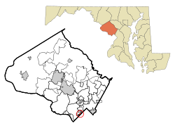
Location of Chevy Chase Village within Montgomery County, Maryland (click to enlarge)
|
|||||
| Country | |||||
| State | |||||
| County | Montgomery | ||||
| Incorporated | 1910 | ||||
| Area | |||||
| • Total | 0.42 sq mi (1.09 km2) | ||||
| • Land | 0.42 sq mi (1.09 km2) | ||||
| • Water | 0.00 sq mi (0.00 km2) | ||||
| Elevation | 345 ft (105 m) | ||||
| Population
(2020)
|
|||||
| • Total | 2,049 | ||||
| • Density | 4,878.57/sq mi (1,885.46/km2) | ||||
| Time zone | UTC-5 (EST) | ||||
| • Summer (DST) | UTC-4 (EDT) | ||||
| ZIP code |
20815
|
||||
| Area code(s) | 301 | ||||
| FIPS code | 24-16787 | ||||
| GNIS feature ID | 2390790 | ||||
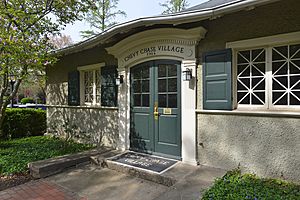
Chevy Chase Village is a small, incorporated town. It is located in Montgomery County, Maryland, right next to Washington, D.C.. In 2020, about 2,049 people lived there.
This town is known for being one of the wealthiest places in Maryland. Many of its homes are quite valuable. Chevy Chase Village has 727 houses. It also has a private club called the Chevy Chase Club.
Contents
History of Chevy Chase Village
In the 1890s, a group of people bought over 1,700 acres of land. This land was in upper Northwest D.C. and southern Montgomery County. They planned to build a new community there.
This new community was named Chevy Chase. The land in Maryland was divided into smaller areas. These areas became known as the Village of Chevy Chase. In 1914, the people living in the Village got permission from the state. This allowed them to collect taxes for local services. The Village officially became a town in 1951.
Where is Chevy Chase Village?
Chevy Chase Village is located at the southern edge of Montgomery County. It shares borders with several other places. To the southeast is the Chevy Chase neighborhood of Washington, D.C.. To the southwest is Friendship Heights Village.
To the west, it borders Somerset. The Chevy Chase Club is to the northwest. The town of Chevy Chase Section Three is to the north. Finally, Martin's Additions is to the northeast.
The town is about 0.42 square miles (1.09 square kilometers) in size. All of this area is land. Water in the western part of town flows into the Little Falls Branch. Water in the eastern part flows into a stream that leads to Rock Creek. Both of these are part of the Potomac River area.
How Many People Live Here?
| Historical population | |||
|---|---|---|---|
| Census | Pop. | %± | |
| 1960 | 2,405 | — | |
| 1970 | 2,265 | −5.8% | |
| 1980 | 2,118 | −6.5% | |
| 1990 | 749 | −64.6% | |
| 2000 | 2,043 | 172.8% | |
| 2010 | 1,953 | −4.4% | |
| 2020 | 2,049 | 4.9% | |
| U.S. Decennial Census | |||
In 2010, there were 1,953 people living in Chevy Chase Village. There were 697 households, which means groups of people living together. Most households were married couples. About 37% of households had children under 18.
The average age of people in the town was about 49 years old. About 26% of residents were under 18. About 20% were 65 years old or older.
Getting Around Chevy Chase Village
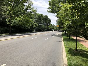
Two main state roads pass through Chevy Chase Village. One is Maryland Route 185, also known as Connecticut Avenue. This road goes north past Interstate 495 (the Capital Beltway). It also goes south into Washington, D.C..
The other road is Maryland Route 186, or Brookville Road. This is a smaller local road. It runs next to Connecticut Avenue to the east.
Schools in Chevy Chase Village
Students in Chevy Chase Village attend schools in the Montgomery County Public Schools system.
Younger students might go to Rosemary Hills Elementary School. This school is for PreK-2 grades. Some students go to Chevy Chase Elementary School for grades 3-6. Others might attend Somerset Elementary School for kindergarten through 5th grade.
All students in the town attend Westland Middle School. They then go on to Bethesda-Chevy Chase High School. Both of these schools are in Montgomery County.
Famous People From Chevy Chase Village
Many interesting people have lived in Chevy Chase Village.
People Who Live Here Now
- Ann Brashares - an author
- Marvin Kalb - a journalist
- Chris Matthews - a TV commentator
- Jerome Powell - the chairman of the Federal Reserve Board of Governors
- John Roberts - the Chief Justice of the United States
- George Will - a commentator
People Who Used to Live Here
- David Brinkley - a journalist
- Sandra Day O'Connor - a United States Supreme Court justice
- Mark Shields - a political writer
See also
 In Spanish: Chevy Chase Village (Maryland) para niños


