Clarence Moreton Basin facts for kids
Quick facts for kids Clarence Moreton Basin |
|
|---|---|

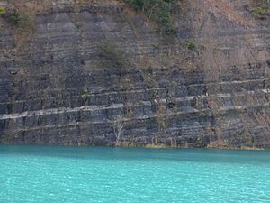
Walloon Coal Measures exposed in quarry at Bexhill
|
|
| Coordinates | 30°00′S 152°30′E / 30°S 152.5°E |
| Location | Northern Rivers, New South Wales & South East Queensland |
| Characteristics | |
| Area | 16,000 km2 (6,200 sq mi) |
| Range | Tweed, Border, Lamington, McPherson |
| Geology | |
| Basin type | Rift basin |
| Age | Late Triassic-Early Cretaceous |
| Stratigraphy | Stratigraphy |
The Clarence Moreton Basin is a huge area of layered rocks in eastern Australia. It's like a giant bowl in the Earth's crust where sediments (like sand, mud, and pebbles) have collected over millions of years. This basin formed during the Mesozoic Era, which is often called the "Age of Dinosaurs."
You can find this basin in the far northeast of New South Wales, near towns like Lismore and Grafton. It also stretches into the southeast part of Queensland. It's actually a part of the much larger Great Artesian Basin, which is one of the biggest underground water sources in the world.
Contents
What is the Clarence Moreton Basin?
This basin formed when the older rocks underneath it stretched and pulled apart. This created a deep dip where layers of sediment could build up. The basin is filled with rocks that formed on land. These include some Triassic coal beds, and mostly Jurassic and Cretaceous sedimentary rocks. These are all different periods in Earth's history.
The Clarence Moreton Basin covers a huge area of about 16,000 square kilometres (6,200 sq mi). It got its name because scientists realized that two areas, the Clarence Basin (named after the Clarence River) and the Moreton Basin in Queensland, were actually connected and part of the same big structure. Scientists believe there might be oil hidden deep within the basin.
Layers of Rock: Stratigraphy
The study of these rock layers is called stratigraphy. It helps us understand the history of the basin.
Oldest Rocks
The very oldest rocks in the New South Wales part of the Clarence Moreton Basin are the Chillingham Volcanics. These rocks formed during the Triassic period. You can see them on the surface near Chillingham. They are made of different kinds of volcanic rocks and some pebble beds.
The Nymboida Coal Measures are another old rock unit. They stretch from Nymboida to Kangaroo Creek. These layers contain sandy rocks, muddy rocks, rocks made of different sized pebbles, coal, and volcanic ash. They are over 1,000 metres (3,300 ft) thick! Fossils found in these rocks tell us they are from the middle Triassic period.
Younger Triassic Layers
The Red Cliff Coal Measures formed in the Late Triassic period. They are found in a belt near Red Cliff. The Evans Head Coal Measures, found further north at Evans Head, are similar to these.
After these layers formed, the basin was lifted up and then deepened again. This allowed more rocks to form. The Bundamba group rocks now form a V-shape on both sides of the basin. In the northern parts, these rocks are mostly crumbly sandstone. In the south, they are divided into pebble beds below and muddy rocks above.
Jurassic Rocks
The Marburg Subgroup stretches for 225 kilometres (140 mi) along the western side of the basin into Queensland. It's mostly sandstone with slanted layers, mixed with layers of clay and mudstone. At the bottom of this subgroup, near Blaxlands Creek, there's a special layer called the Blaxland Fossil Wood Conglomerate Member. It contains fossilized tree trunks up to 18 metres (59 ft) long! These trees turned into limonite and hematite over time.
The Towallum Basalt is a 15-metre (49 ft) thick layer of volcanic rock found near Nymboida. It sits on top of the Marburg formation.
The Walloon Coal Measures form a U-shape around the east, south, and west sides of the basin. These layers contain claystone, shale, siltstone, sandy rocks, and coal seams. Plant fossils found here show that these rocks are from the Jurassic age.
Youngest Layers
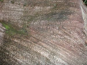
The next layer of rocks, also forming a U-shape, is the Kangaroo Creek Sandstone. This sandstone looks white and creamy and sparkles like sugar. This sparkle comes from tiny silica crystals. It can be up to 150 metres (490 ft) thick.
The Grafton Formation is the youngest sedimentary unit in the center of the basin. It formed between the Late Jurassic and Early Cretaceous periods. You can find it from Grafton to Casino. It's made of soft sandstone, siltstone, and claystone. Volcanic rock called dolerite has pushed into these layers in places like Glenugie Peak.
Finally, the eastern side of the Clarence Moreton Basin was lifted up as the Australian continent began to split apart. This event led to the formation of the Lord Howe Rise and the opening of the ocean floor to the east.
 | Tommie Smith |
 | Simone Manuel |
 | Shani Davis |
 | Simone Biles |
 | Alice Coachman |


