Clay County, Mississippi facts for kids
Quick facts for kids
Clay County
|
|
|---|---|

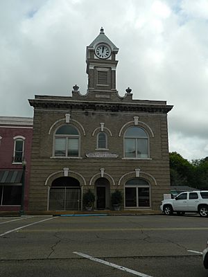
West Point City Hall at West Point Central City Historic District.
|
|

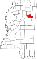
Location within the U.S. state of Mississippi
|
|
 Mississippi's location within the U.S. |
|
| Country | |
| State | |
| Founded | 1871 |
| Named for | Henry Clay |
| Seat | West Point |
| Largest city | West Point |
| Area | |
| • Total | 416 sq mi (1,080 km2) |
| • Land | 410 sq mi (1,100 km2) |
| • Water | 5.9 sq mi (15 km2) 1.4% |
| Population
(2020)
|
|
| • Total | 18,636 |
| • Estimate
(2023)
|
18,206 |
| • Density | 44.80/sq mi (17.297/km2) |
| Time zone | UTC−6 (Central) |
| • Summer (DST) | UTC−5 (CDT) |
| Congressional district | 1st |
Clay County is a county located in the state of Mississippi in the United States. In 2020, about 18,636 people lived here. The main town and county seat is West Point.
The county was named after Henry Clay. He was a famous American politician from Kentucky. He served in the United States Senate and was a United States Secretary of State. Clay County was started in 1871. J. Wesley Caradine, an African American, was the first state representative for the county. Clay County is part of a special area in Mississippi called the Golden Triangle.
Contents
Geography
Clay County covers a total area of about 416 square miles. Most of this area is land, about 410 square miles. The rest, about 5.9 square miles, is water.
Major roads
These are the main roads that go through Clay County:
 U.S. Route 45 Alternate
 Mississippi Highway 25
 Mississippi Highway 46
 Mississippi Highway 47
 Mississippi Highway 50
Neighboring counties
Clay County shares borders with these other counties:
- Chickasaw County (to the north)
- Monroe County (to the northeast)
- Lowndes County (to the southeast)
- Oktibbeha County (to the south)
- Webster County (to the west)
Protected natural areas
A part of the Natchez Trace Parkway runs through Clay County. This is a historic and scenic road.
People and population
| Historical population | |||
|---|---|---|---|
| Census | Pop. | %± | |
| 1880 | 17,367 | — | |
| 1890 | 18,607 | 7.1% | |
| 1900 | 19,563 | 5.1% | |
| 1910 | 20,203 | 3.3% | |
| 1920 | 17,490 | −13.4% | |
| 1930 | 17,931 | 2.5% | |
| 1940 | 19,030 | 6.1% | |
| 1950 | 17,757 | −6.7% | |
| 1960 | 18,933 | 6.6% | |
| 1970 | 18,840 | −0.5% | |
| 1980 | 21,082 | 11.9% | |
| 1990 | 21,120 | 0.2% | |
| 2000 | 21,979 | 4.1% | |
| 2010 | 20,634 | −6.1% | |
| 2020 | 18,636 | −9.7% | |
| 2023 (est.) | 18,206 | −11.8% | |
| U.S. Decennial Census 1790-1960 1900-1990 1990-2000 2010-2013 |
|||
The population of Clay County has changed over the years. The table above shows how many people lived here during different census years.
2020 population details
In 2020, the 2020 United States Census counted 18,636 people living in Clay County. There were 7,618 households and 4,841 families.
Here's a look at the different groups of people living in Clay County in 2020:
| Race | Number of people | Percentage of total |
|---|---|---|
| White | 7,196 | 38.61% |
| Black or African American | 10,785 | 57.87% |
| Native American | 35 | 0.19% |
| Asian | 57 | 0.31% |
| Pacific Islander | 1 | 0.01% |
| Other/Mixed (people of two or more races) | 376 | 2.02% |
| Hispanic or Latino (of any race) | 186 | 1.0% |
2010 population details
According to the 2010 United States Census, there were 20,634 people in the county. About 58.2% were Black or African American. About 40.5% were White. Smaller groups included Asian, Native American, and people of two or more races. About 1.0% of the population was Hispanic or Latino.
Law enforcement
Clay County has a sheriff system for law enforcement. The sheriff and their deputies help keep the community safe.
Education
Students in Clay County can attend schools within the West Point Consolidated School District. This district includes West Point High School. The county is also served by the East Mississippi Community College system, which offers higher education.
Communities
Clay County has one city, one census-designated place, and several smaller communities.
City
- West Point (This is the county seat, where the main government offices are.)
Census-designated place
- Pheba (A place the census bureau defines for statistics.)
Unincorporated communities
These are smaller communities that are not officially part of a city or town:
- Abbott
- Cedarbluff
- Hopewell
- Montpelier
- Tibbee
- Una
- Waverly
- White Station
Ghost town
- Palo Alto (This is a former town that is no longer populated.)
See also
 In Spanish: Condado de Clay (Misisipi) para niños

