Clay County, Nebraska facts for kids
Quick facts for kids
Clay County
|
|
|---|---|

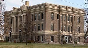
Clay County courthouse in Clay Center
|
|

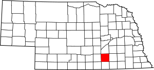
Location within the U.S. state of Nebraska
|
|
 Nebraska's location within the U.S. |
|
| Country | |
| State | |
| Founded | 1855 (authorized) 1871 (organized) |
| Named for | Henry Clay |
| Seat | Clay Center |
| Largest city | Sutton |
| Area | |
| • Total | 574 sq mi (1,490 km2) |
| • Land | 572 sq mi (1,480 km2) |
| • Water | 1.2 sq mi (3 km2) 0.2%% |
| Population
(2020)
|
|
| • Total | 6,104 |
| • Density | 11/sq mi (4/km2) |
| Time zone | UTC−6 (Central) |
| • Summer (DST) | UTC−5 (CDT) |
| Congressional district | 3rd |
Clay County is a county in the state of Nebraska, USA. A county is like a smaller region within a state. As of 2020, about 6,104 people lived here. The main town, or county seat, where the county government is located, is Clay Center.
Clay County was officially created in 1855 and started operating in 1871. It was named after Henry Clay, a famous American politician. Henry Clay was a member of the United States Senate from Kentucky and also served as the United States Secretary of State. In Nebraska's license plate system, Clay County has the number 30. This means it had the 30th-largest number of vehicles registered when the system began in 1922.
Contents
Geography
Clay County covers an area of about 574 square miles. Most of this area, around 572 square miles, is land. A small part, about 1.2 square miles, is water.
Major roads
These are the main roads that pass through Clay County:
Neighboring counties
Clay County shares its borders with these other counties:
- York County – to the northeast
- Fillmore County – to the east
- Thayer County – to the southeast
- Nuckolls County – to the south
- Webster County – to the southwest
- Adams County – to the west
- Hamilton County – to the north
Protected natural areas
Clay County has several special areas set aside to protect nature and wildlife. These are often places where animals can live safely and plants can grow.
- Alberding Lagoon National Wildlife Management Area
- Bluewing Wildlife Management Area
- Eckhardt Lagoon National Wildlife Management Area
- Green Wing State Wildlife Management Area
- Hansen Lagoon National Wildlife Management Area
- Harms Federal Waterfowl Production Area
- Hultine Federal Waterfowl Production Area
- Kissinger Basin State Wildlife Management Area
- Lange Lagoon National Wildlife Management Area
- Massie Federal Waterfowl Production Area
- Meadowlark Federal Waterfowl Production Area
- Moger Lagoon National Wildlife Management Area
- Sandpiper Federal Waterfowl Production Area
- Schuck Federal Waterfowl Production Area
- Smith Lagoon National Wildlife Management Area
- White Front Wildlife Management Area
Population details
| Historical population | |||
|---|---|---|---|
| Census | Pop. | %± | |
| 1860 | 165 | — | |
| 1870 | 54 | −67.3% | |
| 1880 | 11,294 | 20,814.8% | |
| 1890 | 16,310 | 44.4% | |
| 1900 | 15,735 | −3.5% | |
| 1910 | 15,729 | 0.0% | |
| 1920 | 14,486 | −7.9% | |
| 1930 | 13,571 | −6.3% | |
| 1940 | 10,445 | −23.0% | |
| 1950 | 8,700 | −16.7% | |
| 1960 | 8,717 | 0.2% | |
| 1970 | 8,266 | −5.2% | |
| 1980 | 8,106 | −1.9% | |
| 1990 | 7,213 | −11.0% | |
| 2000 | 7,039 | −2.4% | |
| 2010 | 6,542 | −7.1% | |
| 2020 | 6,104 | −6.7% | |
| US Decennial Census 1790-1960 1900-1990 1990-2000 2010 |
|||
In 2000, there were 7,039 people living in Clay County. The population density was about 12 people per square mile. Most people in the county were White, with smaller numbers of other racial groups. About 3.5% of the population identified as Hispanic or Latino. Many residents had German, English, American, Swedish, or Irish family backgrounds.
Towns and places
Clay County has several towns and smaller communities.
Cities
These are the main cities in Clay County:
- Clay Center (This is the county seat)
- Edgar
- Fairfield
- Harvard
- Sutton
Villages
These are smaller villages in the county:
Special community areas
- Inland is a census-designated place, which means it's a community that is recognized for census purposes but isn't an official city or village.
Unincorporated communities
These are small communities that are not officially organized as cities or villages:
Townships
A township is a smaller division of a county, often used for local government or land surveying.
- Edgar
- Eldorado
- Fairfield
- Glenvil
- Harvard
- Inland
- Leicester
- Lewis
- Logan
- Lone Tree
- Lynn
- Marshall
- School Creek
- Sheridan
- Spring Ranch
- Sutton
See also
 In Spanish: Condado de Clay (Nebraska) para niños
 | Shirley Ann Jackson |
 | Garett Morgan |
 | J. Ernest Wilkins Jr. |
 | Elijah McCoy |

