Clearwater County, Minnesota facts for kids
Quick facts for kids
Clearwater County
|
|
|---|---|

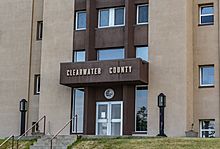
Clearwater County Building and Courthouse in Bagley, Minnesota.
|
|

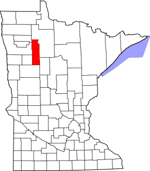
Location within the U.S. state of Minnesota
|
|
 Minnesota's location within the U.S. |
|
| Country | |
| State | |
| Founded | December 20, 1902 |
| Named for | Clearwater Lake Clearwater River |
| Seat | Bagley |
| Largest city | Bagley |
| Area | |
| • Total | 1,030 sq mi (2,700 km2) |
| • Land | 999 sq mi (2,590 km2) |
| • Water | 31 sq mi (80 km2) 3.0%% |
| Population
(2020)
|
|
| • Total | 8,524 |
| • Estimate
(2023)
|
8,644 |
| • Density | 8.5/sq mi (3.3/km2) |
| Time zone | UTC−6 (Central) |
| • Summer (DST) | UTC−5 (CDT) |
| Congressional district | 8th |
Clearwater County is a special area called a county in the northwestern part of Minnesota. Minnesota is a state in the United States. In 2020, about 8,524 people lived here. The main town, or county seat, where the county government is, is Bagley.
Clearwater County is famous because it's where Lake Itasca is located. This lake is the very beginning of the mighty Mississippi River! Also, parts of the Red Lake and White Earth Indian reservations are in this county.
Contents
Exploring Clearwater County's Geography
Clearwater County is a place with lots of natural beauty. It has rolling hills covered in trees and many lakes and ponds.
The Red Lake River starts in Red Lake and flows west across the northern part of the county. It eventually joins the Red River. The Clearwater River also flows through the middle of the county. It goes west-southwest and then joins the Red Lake River.
The county covers about 1,030 square miles. Most of this (999 square miles) is land, and 31 square miles (about 3%) is water. The highest point in the county is over 2,000 feet high!
Main Roads in Clearwater County
These are the most important roads that help people travel through the county:
Neighboring Counties
Clearwater County shares its borders with several other counties:
- Beltrami County to the northeast
- Hubbard County to the southeast
- Becker County to the south
- Mahnomen County to the southwest
- Polk County to the west
- Pennington County to the northwest
Special Protected Areas
Clearwater County has many protected areas. These places help keep nature safe and beautiful. Some of them are:
- Bagley Lake State Wildlife Management Area
- Clearwater State Wildlife Management Area
- Iron Springs Bog SNA
- Itasca State Park (part)
- Jackson Lake State Wildlife Management Area
- Little Pine State Wildlife Management Area
- Lower Rice Lake State Wildlife Management Area
- Old Red Lake Trail State Wildlife Management Area
- Upper Rice Lake State Wildlife Management Area
Clearwater County's Weather
| Weather chart for Bagley, Minnesota | |||||||||||||||||||||||||||||||||||||||||||||||
|---|---|---|---|---|---|---|---|---|---|---|---|---|---|---|---|---|---|---|---|---|---|---|---|---|---|---|---|---|---|---|---|---|---|---|---|---|---|---|---|---|---|---|---|---|---|---|---|
| J | F | M | A | M | J | J | A | S | O | N | D | ||||||||||||||||||||||||||||||||||||
|
0.7
16
-5
|
0.7
22
0
|
0.9
35
14
|
1.6
53
29
|
3
66
42
|
4.6
74
51
|
3.9
79
55
|
3.2
78
52
|
2.9
68
43
|
2.4
54
32
|
1
35
18
|
0.6
21
2
|
||||||||||||||||||||||||||||||||||||
| temperatures in °F precipitation totals in inches source: The Weather Channel |
|||||||||||||||||||||||||||||||||||||||||||||||
|
Metric conversion
|
|||||||||||||||||||||||||||||||||||||||||||||||
The weather in Bagley, the county seat, changes a lot throughout the year. In January, it can be very cold, sometimes as low as -15°F. In July, it gets much warmer, reaching highs of about 85°F.
The county gets different amounts of rain and snow each month. June usually has the most rain, while December has the least.
Who Lives in Clearwater County?
The number of people living in Clearwater County has changed over the years.
| Historical population | |||
|---|---|---|---|
| Census | Pop. | %± | |
| 1910 | 6,870 | — | |
| 1920 | 8,569 | 24.7% | |
| 1930 | 9,546 | 11.4% | |
| 1940 | 11,153 | 16.8% | |
| 1950 | 10,204 | −8.5% | |
| 1960 | 8,864 | −13.1% | |
| 1970 | 8,013 | −9.6% | |
| 1980 | 8,761 | 9.3% | |
| 1990 | 8,309 | −5.2% | |
| 2000 | 8,423 | 1.4% | |
| 2010 | 8,695 | 3.2% | |
| 2020 | 8,524 | −2.0% | |
| 2023 (est.) | 8,643 | −0.6% | |
| U.S. Decennial Census 1790-1960 1900-1990 1990-2000 2010-2020 |
|||
People in 2020
In 2020, the census counted the people living in Clearwater County. Here's a look at the different groups:
| Race | Number of People | Percentage |
|---|---|---|
| White | 7,151 | 83.9% |
| Black or African American | 19 | 0.2% |
| Native American | 752 | 8.82% |
| Asian | 23 | 0.3% |
| Pacific Islander | 2 | 0.02% |
| Other/Mixed | 476 | 5.6% |
| Hispanic or Latino | 101 | 1.2% |
Towns and Places in Clearwater County
Clearwater County has several towns and smaller communities where people live.
Cities
These are the main cities in the county:
- Bagley (This is the county seat!)
- Clearbrook
- Gonvick
- Leonard
- Shevlin
Census-Designated Places (CDPs)
These are areas that are like towns but are not officially incorporated as cities:
Unincorporated Communities
These are smaller places that are not part of any city or CDP:
Townships
Townships are smaller local government areas within the county:
- Bear Creek Township
- Clover Township
- Copley Township
- Dudley Township
- Eddy Township
- Falk Township
- Greenwood Township
- Hangaard Township
- Holst Township
- Itasca Township
- La Prairie Township
- Leon Township
- Long Lost Lake Township
- Minerva Township
- Moose Creek Township
- Nora Township
- Pine Lake Township
- Popple Township
- Rice Township
- Shevlin Township
- Sinclair Township
- Winsor Township
Unorganized Territories
These are parts of the county that are not part of any township:
See also
 In Spanish: Condado de Clearwater (Minnesota) para niños
 | Aaron Henry |
 | T. R. M. Howard |
 | Jesse Jackson |

