
Coatzacoalcos facts for kids
Quick facts for kids
Coatzacoalcos
|
||
|---|---|---|
|
City and municipality
|
||
    .jpg) Top: Panoramic view of Coatzacoalcos's downtown; Middle: Olmec Archaeology Museum, Cathedral of Saint Joseph; Bottom: Coatzacoalcos jetty, stairways at the riverside front
|
||
|
||
| Nickname(s):
La Ciudad de las Avenidas (The City of Avenues)
|
||

Coatzacoalcos
Location in Mexico
|
||
| Country | Mexico | |
| State | Veracruz | |
| Founded | 1522 | |
| Area | ||
| • Municipality | 309.2 km2 (119.4 sq mi) | |
| Highest elevation | 50 m (160 ft) | |
| Lowest elevation | 0 m (0 ft) | |
| Population
(2020)
|
||
| • Municipality | 310,698 | |
| • Density | 1,004.8/km2 (2,602/sq mi) | |
| • Seat | 212,540 | |
| • Metro | 354,606 | |
| • Metro density | 714.64/km2 (1,850.9/sq mi) | |
| Time zone | UTC−6 (CST) | |
| • Summer (DST) | UTC−5 (CDT) | |
| Postal code |
96380 – 96599
|
|
| Area code(s) | 921 | |

Coatzacoalcos is a big port city in the southern part of the Mexican state of Veracruz. It's mostly located on the western side of the Coatzacoalcos River where it meets the sea. This city is on the Bay of Campeche, which is part of the southern Gulf of Mexico coast.
Coatzacoalcos is the main city of its municipality. In 2020, about 212,540 people lived in the city itself. This makes it the third-largest city in the state, after Veracruz and Xalapa. The whole municipality had a population of 310,698 people.
Contents
- What Does Coatzacoalcos Mean?
- A Look at Coatzacoalcos's Past
- Where is Coatzacoalcos and What's its Weather Like?
- How Coatzacoalcos Makes Money
- Population of Coatzacoalcos
- Learning and Sports in Coatzacoalcos
- Getting Around Coatzacoalcos
- Famous People from Coatzacoalcos
- Sister Cities
- Images for kids
- See also
What Does Coatzacoalcos Mean?
The name Coatzacoalcos comes from the Nahuatl language. It means "site of the Snake" or "where the snake hides."
According to an old legend, this is the place where the god Quetzalcoatl went on his last journey to the sea. This happened around the year 999. The legend says he promised to return one day.
A Look at Coatzacoalcos's Past

Coatzacoalcos is in the area where the ancient Olmec heartland was located. In 2008, during work on a tunnel under the Coatzacoalcos River, people found signs of a large population living here long before the Spanish arrived.
When the Spanish came, the area was influenced by the Mayan people. In 1522, Hernán Cortés told Gonzalo de Sandoval to start a settlement near Guazacualco. Sandoval named this new place Villa del Espíritu Santo.
There's an active volcano called San Martín Tuxtla northwest of Coatzacoalcos. It's part of the Sierra de los Tuxtlas mountains. This volcano erupted in 1664, then again in May 1793 with lots of ash and lava. Its most recent eruption was in 1796.
The town became an official port in 1825. At that time, its name was changed to Coatzacoalcos.
The area around Coatzacoalcos became a municipality on December 22, 1881. The town was its main center. In 1900, the town's name was changed to Puerto México. It became a city in 1911. Finally, in 1936, its name was changed back to the current Coatzacoalcos.
On July 23, 1940, Coatzacoalcos welcomed people who were escaping the Spanish Civil War. They traveled across the Atlantic Ocean on a ship called the SS Santo Domingo to find safety in Mexico.
In 1959, the city was damaged by a strong earthquake.
Coatzacoalcos became a very important place in the 1970s. This was during a time when oil production was booming. The city connected the Yucatán Peninsula and oil fields in Campeche to the rest of Mexico. It also linked to the port of Salina Cruz in Oaxaca on the Pacific coast.
Where is Coatzacoalcos and What's its Weather Like?
The city is located at 18°9′N 94°26′W / 18.150°N 94.433°W. This is where the Coatzacoalcos River flows into the Bay of Campeche. By land, roads and railways connect it to the Pacific Ocean, which is about 160 kilometres (99 mi) away. Because of this special location, there have been plans for over a hundred years to build a waterway or a much bigger railroad system across the Isthmus of Tehuantepec. This would connect the Atlantic and Pacific oceans.
Coatzacoalcos has a tropical monsoon climate. This means it gets a lot of rain, usually more than 290 centimetres (110 in) each year.
Since it's on the Gulf of Mexico, Coatzacoalcos has been hit by several hurricanes and tropical storms. Some of these include Hurricane Diana in 1990 and Hurricane Mitch in 1998. More recently, Hurricane Agatha hit in May 2022. The winter months are cooler and drier than the summer months. Sometimes, cold winds from North America blow south across the Gulf of Mexico. These can cause very strong winds across the Isthmus.
| Climate data for Coatzacoalcos, Veracruz (1981–2000) | |||||||||||||
|---|---|---|---|---|---|---|---|---|---|---|---|---|---|
| Month | Jan | Feb | Mar | Apr | May | Jun | Jul | Aug | Sep | Oct | Nov | Dec | Year |
| Record high °C (°F) | 39.5 (103.1) |
40.0 (104.0) |
39.1 (102.4) |
41.2 (106.2) |
42.5 (108.5) |
43.0 (109.4) |
40.0 (104.0) |
39.0 (102.2) |
38.0 (100.4) |
38.3 (100.9) |
35.6 (96.1) |
37.2 (99.0) |
43.0 (109.4) |
| Mean daily maximum °C (°F) | 25.6 (78.1) |
26.6 (79.9) |
28.9 (84.0) |
31.0 (87.8) |
32.1 (89.8) |
31.8 (89.2) |
30.6 (87.1) |
30.8 (87.4) |
30.3 (86.5) |
29.0 (84.2) |
28.0 (82.4) |
26.2 (79.2) |
29.2 (84.6) |
| Daily mean °C (°F) | 22.6 (72.7) |
23.6 (74.5) |
25.3 (77.5) |
27.3 (81.1) |
28.6 (83.5) |
28.4 (83.1) |
27.1 (80.8) |
27.8 (82.0) |
27.3 (81.1) |
26.2 (79.2) |
25.2 (77.4) |
23.5 (74.3) |
26.1 (79.0) |
| Mean daily minimum °C (°F) | 19.6 (67.3) |
20.5 (68.9) |
21.7 (71.1) |
23.5 (74.3) |
25.2 (77.4) |
25.0 (77.0) |
23.6 (74.5) |
24.7 (76.5) |
24.2 (75.6) |
23.4 (74.1) |
22.4 (72.3) |
20.8 (69.4) |
22.9 (73.2) |
| Record low °C (°F) | 11.7 (53.1) |
9.6 (49.3) |
11.8 (53.2) |
12.0 (53.6) |
19.1 (66.4) |
19.9 (67.8) |
17.1 (62.8) |
20.8 (69.4) |
19.0 (66.2) |
18.0 (64.4) |
14.9 (58.8) |
12.0 (53.6) |
9.6 (49.3) |
| Average precipitation mm (inches) | 95.1 (3.74) |
58.2 (2.29) |
46.1 (1.81) |
48.4 (1.91) |
155.2 (6.11) |
234.8 (9.24) |
268.2 (10.56) |
311.0 (12.24) |
506.2 (19.93) |
364.6 (14.35) |
265.8 (10.46) |
223.6 (8.80) |
2,577.1 (101.46) |
| Average precipitation days (≥ 0.1 mm) | 11.0 | 6.3 | 4.6 | 4.7 | 5.1 | 12.9 | 14.9 | 19.1 | 19.9 | 14.1 | 12.6 | 11.6 | 136.6 |
| Average relative humidity (%) | 82 | 80 | 73 | 74 | 75 | 77 | 79 | 79 | 80 | 78 | 80 | 81 | 78 |
| Mean monthly sunshine hours | 132 | 143 | 192 | 211 | 209 | 195 | 199 | 199 | 166 | 159 | 147 | 123 | 2,075 |
| Source: Servicio Meteorológico Nacional | |||||||||||||
How Coatzacoalcos Makes Money

The main industry in Coatzacoalcos is petrochemicals. This means they work with oil and gas to make different chemical products. There are four large petrochemical factories near the city. These factories make Coatzacoalcos one of the most important places for this industry in the world.
The company Pemex Petroquímica, which is owned by the state, has its main office in Coatzacoalcos. About 85% of its production happens here.
Population of Coatzacoalcos
| Historical population | ||
|---|---|---|
| Year | Pop. | ±% |
| 1995 | 259,069 | — |
| 2000 | 267,212 | +3.1% |
| 2005 | 380,363 | +42.3% |
| 2010 | 305,260 | −19.7% |
| 2015 | 319,187 | +4.6% |
| 2020 | 310,698 | −2.7% |
In 2020, the whole municipality of Coatzacoalcos had 310,698 people living in it. About 212,540 of these people lived in the main city area. This makes it the third-largest city in the state, after Veracruz and Xalapa.
Other towns in the area include Olmec City (with 24,085 people), Allende (23,351 people), Villa San Martín (15,659 people), and Puerto Esmeralda (9,585 people). Coatzacoalcos is also part of a larger metropolitan area. This area includes the nearby municipalities of Ixhuatlán del Sureste and Nanchital de Lázaro Cárdenas del Río. In 2020, this larger area had a total population of 354,606 people.
Learning and Sports in Coatzacoalcos
The Universidad Veracruzana has a campus and a library in Coatzacoalcos. Also, TecNM has a campus in the city, offering more education options.
For sports, the city used to have a soccer team called the Tiburones Rojos de Coatzacoalcos (Red Sharks). They played in a league until 2008. The Delfines de Coatzacoalcos (Dolphins) soccer team plays at the Estadio Rafael Hernández Ochoa, which was built in 1980. Another team, the Universidad Istmo Americana F.C., also plays soccer in Coatzacoalcos.
Getting Around Coatzacoalcos
Coatzacoalcos has been an important place for transportation for hundreds of years. You can travel to and from the city by air, water, road, and rail.
The Minatitlán/Coatzacoalcos National Airport is about 15 kilometres (9.3 mi) away in Cosoleacaque. It has been an international airport since 2006.
The Port of Coatzacoalcos is an international port. It helps move oil and petrochemical products. After a railway upgrade in 1907, more ships used the port. This was especially true for the American-Hawaiian Steamship Company. Traffic slowed down after the Panama Canal opened in 1914. However, it started to grow again during the oil boom of the 1970s. This railway is now known as the Ferrocarril Transístmico (Trans-Isthmic Railroad).
The CG Railway runs special train ferries between the Port of Coatzacoalcos and the United States. These ferries go to the Port of Mobile in Alabama. Another railway company, Ferrosur, also provides train service. You can travel from Coatzacoalcos to places like Las Choapas, Veracruz, and Mexico City. There's also a route south over the Tehuantepec line to Salina Cruz in Oaxaca.
Mexican Federal Highway 180 runs along the southern shore of the Bay of Campeche through Coatzacoalcos. This highway and a railway line cross the Coatzacoalcos River using the Coatza I bridge, which was built in 1910. A second bridge, called Coatza II or Antonio Dovalí Jaime, was built to the south. It helps carry more road traffic over the river. This bridge was opened in 1984.
There's also a ferry that goes between the city of Coatzacoalcos and Allende. In 2017, an underwater tunnel was built to help with traffic. It's 1.1-kilometre (0.68 mi) long and has four lanes. Coatzacoalcos is also the start of Mexican Federal Highway 185. This highway connects it to the Pacific Ocean at Salina Cruz, Oaxaca, on the other side of the Isthmus of Tehuantepec.
Famous People from Coatzacoalcos
Some well-known people were born in Coatzacoalcos:
- Salma Hayek, a famous actress.
- María Antonieta Collins, a journalist.
- Sergio Ramirez, a footballer who played for FC Ararat Yerevan.
- José Arturo Rivas, a footballer who played for Tigres de la UANL.
- Silviano Delgado Valladolid, who was part of Mexico's National Squad for the 1992 Barcelona Olympic Games and played for several soccer clubs.
Sister Cities
Coatzacoalcos has two sister cities:
 Rizhao, China
 San Fernando, Philippines
Images for kids
-
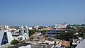
Panoramic view of Coatzacoalcos's downtown
-
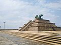
Olmec Archaeology Museum
-
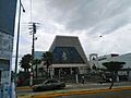
Cathedral of Saint Joseph
-
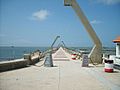
Coatzacoalcos jetty
-
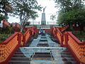
Stairways at the riverside front
-
Seal of Coatzacoalcos
See also
 In Spanish: Coatzacoalcos para niños
