
Concho County, Texas facts for kids
Quick facts for kids
Concho County
|
|
|---|---|

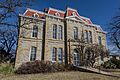
The Concho County Courthouse in Paint Rock
|
|

Location within the U.S. state of Texas
|
|
 Texas's location within the U.S. |
|
| Country | |
| State | |
| Founded | 1879 |
| Named for | Concho River |
| Seat | Paint Rock |
| Largest city | Eden |
| Area | |
| • Total | 994 sq mi (2,570 km2) |
| • Land | 984 sq mi (2,550 km2) |
| • Water | 9.9 sq mi (26 km2) 1.0% |
| Population
(2020)
|
|
| • Total | 3,303 |
| • Density | 3.3229/sq mi (1.2830/km2) |
| Time zone | UTC−6 (Central) |
| • Summer (DST) | UTC−5 (CDT) |
| Congressional district | 11th |

Concho County is a special area in the state of Texas, USA. It is located on the Edwards Plateau, a high, flat area of land. In 2020, about 3,303 people lived here. The main town and center of the county is Paint Rock. Concho County was officially created in 1858 and started operating in 1879. It gets its name from the nearby Concho River.
Contents
History of Concho County
Early People and Explorers
Long ago, in the 1800s, Paleo-Indians lived in the area that is now Concho County. They left behind old cooking sites called burned-rock middens. Later, other Native American groups lived here. These included the Jumano, Tonkawa, Comanche, and Lipan Apache tribes.
In 1847, a man named John O. Meusebach sent people to explore and map the area. Two years later, in 1849, Robert Simpson Neighbors led a small group through the county.
Forming the County
The Texas government officially created Concho County in 1858. It was formed from a much larger area called Bexar County.
By 1874, more people began to settle in the area. The town of Paint Rock was officially named the county seat. It was named after the ancient rock paintings found nearby. The community of Eden was started in 1882. Later, in 1909, the town of Lowake was established.
Railroads Arrive
Trains came to Concho County in the early 1900s. This made it easier to travel and move goods.
- In 1910, the Concho, San Saba and Llano Valley railroad reached Paint Rock.
- In 1911, the Fort Worth and Rio Grande Railway built tracks through the southeastern part of the county.
- In 1912, the Gulf, Colorado and Santa Fe railroad completed a line to Eden.
Farming and Water
By 1930, many people in Concho County worked on farms. There were 449 farms owned by families and 682 farms worked by tenants.
In 1940, Concho County became part of a special district to help protect the soil. This helped farmers keep their land healthy. In 1985, permission was given to build a large dam on the Colorado River. This created the O. H. Ivie Reservoir, which holds a lot of water.
By 1988, Concho County was known for raising many sheep. It was the top sheep-producing county in Texas!
Geography of Concho County
Concho County covers about 994 square miles (2,574 square kilometers). Most of this area, about 984 square miles (2,549 square kilometers), is land. The rest, about 9.9 square miles (26 square kilometers), is water.
Main Roads in the County
Several important highways pass through Concho County:
 U.S. Highway 83
 U.S. Highway 87
 State Highway 153
 State Highway 206
Neighboring Counties
Concho County shares borders with several other counties:
- Runnels County (to the north)
- Coleman County (to the northeast)
- McCulloch County (to the east)
- Menard County (to the south)
- Schleicher County (to the southwest)
- Tom Green County (to the west)
Population Information
| Historical population | |||
|---|---|---|---|
| Census | Pop. | %± | |
| 1880 | 800 | — | |
| 1890 | 1,065 | 33.1% | |
| 1900 | 1,427 | 34.0% | |
| 1910 | 6,654 | 366.3% | |
| 1920 | 5,847 | −12.1% | |
| 1930 | 7,645 | 30.8% | |
| 1940 | 6,192 | −19.0% | |
| 1950 | 5,078 | −18.0% | |
| 1960 | 3,672 | −27.7% | |
| 1970 | 2,937 | −20.0% | |
| 1980 | 2,915 | −0.7% | |
| 1990 | 3,044 | 4.4% | |
| 2000 | 3,966 | 30.3% | |
| 2010 | 4,087 | 3.1% | |
| 2020 | 3,303 | −19.2% | |
| U.S. Decennial Census 1850–2010 2010 2020 |
|||
In 2000, there were 3,966 people living in Concho County. The population density was about 4 people per square mile.
The county had 1,058 households. About 29.8% of these households had children under 18 living with them. Most households (59.4%) were married couples.
The median age of people in Concho County was 36 years old. This means half the people were younger than 36 and half were older. For every 100 females, there were about 181 males.
The average income for a household in 2000 was $31,313 per year. About 11.9% of the population lived below the poverty line. This included 15.8% of children under 18.
Towns and Communities
Concho County has a few towns and smaller communities.
Cities
Towns
- Paint Rock (This is the county seat, where the main government offices are.)
Small Communities
These places are not officially cities or towns:
- Eola
- Lowake
- Millersview
- Vick
Old or "Ghost" Towns
Some communities that used to exist in Concho County are now empty or have very few people:
- Concho
- Henderson Chapel
- Lightner
- Live Oak
- Pasche
Images for kids
-
The Concho County Courthouse in Paint Rock
See also
 In Spanish: Condado de Concho para niños
