
Couesnon facts for kids
Quick facts for kids Couesnon |
|
|---|---|

The Couesnon near Pontorson
|
|
| Country | France |
| Physical characteristics | |
| Main source | Pays de la Loire |
| River mouth | English Channel 48°37′4″N 1°30′41″W / 48.61778°N 1.51139°W |
| Length | 101 km |
The Couesnon River is a river in France. It starts in the Mayenne area in north-western France. The river flows into the English Channel at Mont Saint-Michel. This is where the river meets the sea.
The last part of the Couesnon River forms the border between two old French regions: Normandy and Brittany. In the past, the river often changed its path. It would flow either north or south of Mont Saint-Michel. Eventually, it settled on the south side. This led to a famous saying: "The Couesnon's madness placed Mont Saint-Michel in Normandy." This is because the famous Mont Saint-Michel is now just on the Normandy side of the river's mouth. However, the official border between the two regions doesn't follow the river's path exactly. It's actually about six kilometers west of Mont Saint-Michel.
River's Journey
The Couesnon River is part of a group of rivers that flow into the bay of Mont Saint-Michel. These rivers are the Couesnon, the Sée, and the Sélune. The bay has a special water system. The ocean's tide brings in a lot of sand and mud, called sediment. This causes large sandbars to form in the river. But the three rivers also carry this sediment back out to sea.
In the 1900s, people changed the Couesnon River. They made it more like a canal. This helped to stop the river banks from wearing away, a process called erosion. In 1969, a dam was built on the river. These changes, along with a road (called a causeway) that connected Mont Saint-Michel to the mainland, caused muddy areas to form.
To fix this, the French built a bridge to replace the old causeway. This bridge was finished in 2013. It helps the river flow more freely. This helps to wash away the extra mud and sand, known as silt.
During very high tides, called spring tides, you can sometimes see a special wave. This wave, called a tidal bore, travels up the river. It's caused by the rising tide.
The Couesnon River flows through these French areas and towns:
- Ille-et-Vilaine: Fougères, Antrain
- Manche: Pontorson
River Water Facts
In the summer, the amount of water flowing in the Couesnon River is usually about 4.2 cubic meters per second. Scientists have measured the water's pH at 8.26. This number tells us how acidic or basic the water is. A pH of 7 is neutral.
In the summer, near where the river meets the sea, the water temperature is about 19 degrees Celsius. The water is moderately clear. You can see about 14 centimeters deep using a special tool called a Secchi disc. The water near the mouth also has high electrical conductivity. This means it has a lot of dissolved salts, which is normal for water close to the ocean.
Gallery
-
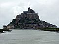
The mouth of the Couesnon, at Mont Saint-Michel
-
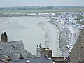
The causeway connecting Mont Saint-Michel to the mainland, which caused a lot of mud and sand to build up
-
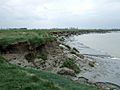
The muddy edges of the Couesnon are almost like quicksand


- Hogan, C Michael, Water quality of freshwater bodies in France, Lumina Tech. Press, Aberdeen (2006)
Images for kids
-

Harold Godwinson and his men cross flumen Cosnonis (the Cousesnon) in the Bayeux Tapestry

See also
 In Spanish: Río Couesnon para niños
