Crawford County, Indiana facts for kids
Quick facts for kids
Crawford County
|
|
|---|---|

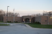
Crawford County Courthouse in English
|
|

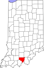
Location within the U.S. state of Indiana
|
|
 Indiana's location within the U.S. |
|
| Country | |
| State | |
| Founded | January 5, 1818 |
| Named for | William H. Crawford |
| Seat | English |
| Largest town | Marengo |
| Area | |
| • Total | 308.72 sq mi (799.6 km2) |
| • Land | 305.64 sq mi (791.6 km2) |
| • Water | 3.08 sq mi (8.0 km2) 1.00%% |
| Population
(2020)
|
|
| • Total | 10,526 |
| • Estimate
(2023)
|
10,438 |
| • Density | 34.0956/sq mi (13.1644/km2) |
| Time zone | UTC−5 (Eastern) |
| • Summer (DST) | UTC−4 (EDT) |
| Congressional districts | 8th, 9th |
| Indiana county number 13 | |
Crawford County is a county found in the state of Indiana. In 2020, about 10,526 people lived there. The main town, or county seat, is English.
Contents
Exploring Crawford County
Crawford County covers a total area of about 308.72 square miles. Most of this area, about 305.64 square miles, is land. The rest, about 3.08 square miles, is water.
Towns and Cities
Here are some of the main towns and cities in Crawford County:
Smaller Communities
There are also many smaller communities in the county. These are called unincorporated areas. They include:
- Beechwood
- Carefree
- Curby
- Eckerty
- Fredonia
- Grantsburg
- Mifflin
- Riceville
- Riddle
- Sulphur
- Taswell
- West Fork
- Wickliffe
Local Areas (Townships)
Crawford County is divided into smaller areas called townships. Each township helps manage local services.
- Boone
- Jennings
- Johnson
- Liberty
- Ohio
- Patoka
- Sterling
- Union
- Whiskey Run
Main Roads
Several important roads pass through Crawford County. These highways help people travel around the area.
 Interstate 64
 Indiana State Road 37
 Indiana State Road 62
 Indiana State Road 64
 Indiana State Road 66
 Indiana State Road 145
Neighboring Counties
Crawford County shares its borders with several other counties:
- Orange County (to the north)
- Washington County (to the northeast)
- Harrison County (to the east)
- Meade County, Kentucky (to the south)
- Perry County (to the southwest)
- Dubois County (to the west)
Protected Natural Areas
A part of the Hoosier National Forest is located within Crawford County. This forest helps protect nature and offers outdoor activities.
History of Crawford County
Crawford County was officially created in 1818. There are two main ideas about how it got its name. Some believe it was named after William H. Crawford. He was the U.S. Treasury Secretary in 1818.
Others think it was named for Colonel William Crawford. He was a soldier who fought in the French and Indian War and the American Revolutionary War. He was captured and died in 1782.
For many years, the county seat was in Leavenworth. Later, it was moved to English, where it is today.
Weather in English, Indiana
| Weather chart for English, Indiana | |||||||||||||||||||||||||||||||||||||||||||||||
|---|---|---|---|---|---|---|---|---|---|---|---|---|---|---|---|---|---|---|---|---|---|---|---|---|---|---|---|---|---|---|---|---|---|---|---|---|---|---|---|---|---|---|---|---|---|---|---|
| J | F | M | A | M | J | J | A | S | O | N | D | ||||||||||||||||||||||||||||||||||||
|
3.7
41
21
|
3.5
48
24
|
4.8
59
33
|
4.7
69
41
|
5.1
77
49
|
4.8
85
59
|
4.2
88
63
|
3.9
87
61
|
3.6
81
53
|
3.1
70
41
|
4.4
57
34
|
4
46
25
|
||||||||||||||||||||||||||||||||||||
| temperatures in °F precipitation totals in inches source: The Weather Channel |
|||||||||||||||||||||||||||||||||||||||||||||||
|
Metric conversion
|
|||||||||||||||||||||||||||||||||||||||||||||||
The weather in English, Indiana, changes throughout the year. In January, the average low temperature is about 21°F. In July, the average high temperature is about 88°F.
The coldest temperature ever recorded was -31°F in January 1977. The hottest was 104°F in July 1983.
Rainfall also varies. October usually gets the least rain, about 3.13 inches. May often gets the most, with about 5.06 inches.
Who Lives in Crawford County?
| Historical population | |||
|---|---|---|---|
| Census | Pop. | %± | |
| 1820 | 2,583 | — | |
| 1830 | 3,238 | 25.4% | |
| 1840 | 5,282 | 63.1% | |
| 1850 | 6,524 | 23.5% | |
| 1860 | 8,226 | 26.1% | |
| 1870 | 9,851 | 19.8% | |
| 1880 | 12,356 | 25.4% | |
| 1890 | 13,941 | 12.8% | |
| 1900 | 13,476 | −3.3% | |
| 1910 | 12,057 | −10.5% | |
| 1920 | 11,201 | −7.1% | |
| 1930 | 10,160 | −9.3% | |
| 1940 | 10,171 | 0.1% | |
| 1950 | 9,289 | −8.7% | |
| 1960 | 8,379 | −9.8% | |
| 1970 | 8,033 | −4.1% | |
| 1980 | 9,820 | 22.2% | |
| 1990 | 9,914 | 1.0% | |
| 2000 | 10,743 | 8.4% | |
| 2010 | 10,713 | −0.3% | |
| 2020 | 10,526 | −1.7% | |
| 2023 (est.) | 10,438 | −2.6% | |
| U.S. Decennial Census 1790-1960 1900-1990 1990-2000 2010-2013 |
|||
In 2010, there were 10,713 people living in Crawford County. These people lived in 4,303 homes. About 2,991 of these were families.
The county had about 35 people per square mile. Most people (97.4%) were white. About 1.2% of the population was of Hispanic or Latino background.
Many families had children under 18 living with them (30.6%). The average age of people in the county was about 41.8 years old.
2020 Census Information
Here's a look at the different groups of people living in Crawford County in 2020:
| Race | Num. | Perc. |
|---|---|---|
| White (NH) | 9,989 | 95% |
| Black or African American (NH) | 26 | 0.2% |
| Native American (NH) | 23 | 0.2% |
| Asian (NH) | 17 | 0.16% |
| Pacific Islander (NH) | 1 | 0.01% |
| Other/Mixed (NH) | 349 | 3.3% |
| Hispanic or Latino | 121 | 1.1% |
See also
 In Spanish: Condado de Crawford (Indiana) para niños
 | May Edward Chinn |
 | Rebecca Cole |
 | Alexa Canady |
 | Dorothy Lavinia Brown |

