
Creise facts for kids
Quick facts for kids Creise |
|
|---|---|

Creise (left) and Meall a' Bhuiridh (right) seen from the SE.
|
|
| Highest point | |
| Elevation | 1,100 m (3,600 ft) |
| Prominence | 168 m (551 ft) |
| Parent peak | Meall a' Bhuiridh |
| Listing | Munro, Marilyn |
| Naming | |
| English translation | Grease or Fat |
| Language of name | Gaelic |
| Pronunciation | kraysh |
| Geography | |
| Location | Highland, Scotland |
| Parent range | Grampians |
| OS grid | NN238506 |
| Topo map | OS Landranger 50, 41 OS Explorer 384 |
| Listed summits of Creise | ||||
| Name | Grid ref | Height | Status | |
|---|---|---|---|---|
| Clach Leathad | NN240493 | 1099 m (3605 ft) | Munro Top | |
| Stob a’ Ghlais Choire | NN239516 | 996 m (3268 ft) | Munro Top | |
Creise is a tall Scottish mountain. It stands at the eastern end of Glen Coe. You can find it just south of the A82 road. It is about 26 kilometers south-southeast of Fort William. This area is part of the Highland Council. The mountain was once known as Clach Leathad. This name meant "Stony Slope." Its name changed to Creise in 1981. This happened when new mapping showed its highest point was further north.
Contents
About Creise
Creise is one of four important mountains in the Black Mount area. These mountains are called Munros. A Munro is a Scottish mountain over 3,000 feet (914.4 meters) high. Creise reaches a height of 1100 meters (about 3609 feet). It is well-known to both skiers and hikers. This is because it sits right next to the White Corries ski area. Many people climb Creise from here. They often climb it along with its neighbor, Meall a' Bhuiridh. These two mountains are popular for cross-country skiers.
You can see Creise clearly from the A82 road. The Kings House Hotel also has a great view of it. From there, you can see its steep northern side called Sròn na Creise. For many years, people did not know what the name Creise meant. Now, experts say "creis" means "grease" or "fat." This refers to the rich land around the hill. This land was used by herdsmen to fatten their cattle long ago.
Mountain Shape and High Points
Creise is a long mountain shaped like a whale's back. It runs from north to south. Its top ridge is three kilometers long. It has four main high points.
Clach Leathad
The most southern high point is Clach Leathad. It is 1099 meters high. This is just one meter lower than the main summit. Until the 1970s, people thought Clach Leathad was the highest point. In 1981, it was changed to a "Munro Top." A Munro Top is a peak that is part of a Munro but not the highest point.
Other High Points
About 700 meters north of Clach Leathad is Mam Coire Easain. It is 1070 meters high. This was also a "Munro Top" but was removed in 1981. It is important because it connects Creise to Meall a' Bhuiridh. The main summit of Creise is 650 meters further north. This point was not named on maps before 1981. Then, it became the official Munro summit.
A fourth high point is Stob a’ Ghlais Choire. It is 996 meters high. This "Munro Top" is at the northern end of the ridge. It is above the steep rocks of Sròn na Creise. These rocks drop sharply to the River Etive valley. Climbing Sròn na Creise is a challenging route. It needs extra care in winter. Some serious accidents have happened there.
Water Flow
Rainfall on Creise flows to both sides of Scotland. Water from the south of the mountain goes into Coire Ba. This is one of Scotland's biggest valleys. This water then reaches the east coast. It flows into the Firth of Tay through the Rivers Ba, Tummel, and Tay. All other water from Creise flows west. It goes through Glen Etive and Loch Etive. This water reaches the west coast near Oban.
How to Climb Creise
The most popular way to climb Creise starts at the White Corries ski Centre. You can find it at grid reference NN266525. Many people climb Meall a' Bhuiridh first. They follow the path of the ski chair lift. However, most serious climbers do not use the lift itself. The lifts go right up to the summit of Meall a' Bhuiridh.
To continue to Creise, you go southwest and then west. You cross a low point between the two mountains. This low point is 932 meters high. From there, you reach the flat top of Creise.
You can also climb Creise directly from the ski center. This route goes west across open land. It reaches the bottom of Sròn na Creise. Then, it's a climb up the rocks to the northern end of the summit ridge.
Creise can also be part of a longer walk. This walk is called the Clachlet Traverse. It is a 25-kilometer classic route. It goes between the Inveroran Inn and the Kings House Inn. This walk includes all four Black Mount Munros. It involves climbing about 1700 meters in total. From the top of Creise, you get great views. You can see the cliffs of Buachaille Etive Mòr up close. You can also see the western part of Rannoch Moor.
Images for kids
-
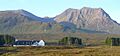
The northern cliffs of Creise tower behind the Kings House Hotel.
-
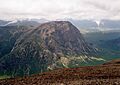
Buachaille Etive Mòr seen from the summit of Creise.


