Crittenden County, Arkansas facts for kids
Quick facts for kids
Crittenden County
|
|
|---|---|

Crittenden County Courthouse in Marion
|
|

Location within the U.S. state of Arkansas
|
|
 Arkansas's location within the U.S. |
|
| Country | |
| State | |
| Founded | October 22, 1825 |
| Named for | Robert Crittenden |
| Seat | Marion |
| Largest city | West Memphis |
| Area | |
| • Total | 636 sq mi (1,650 km2) |
| • Land | 610 sq mi (1,600 km2) |
| • Water | 27 sq mi (70 km2) 4.2%% |
| Population
(2020)
|
|
| • Total | 48,163 |
| • Estimate
(2023)
|
47,139 |
| • Density | 75.73/sq mi (29.239/km2) |
| Time zone | UTC−6 (Central) |
| • Summer (DST) | UTC−5 (CDT) |
| Congressional district | 1st |
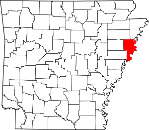
Crittenden County is a county located in the state of Arkansas, USA. In 2020, about 48,163 people lived here. The main town, or county seat, is Marion. The biggest city is West Memphis. Crittenden County is part of the larger Memphis, TN-MS-AR Metropolitan Statistical Area. This means it's connected to the big city of Memphis.
Contents
History
Crittenden County is the 12th county created in Arkansas. It was formed on October 22, 1825. The county was named after Robert Crittenden. He was the first Secretary of the Arkansas Territory.
The first county seat was a community called Greenock. Court meetings were held there starting in 1826. After about ten years, the county seat moved to Marion.
Geography
Crittenden County covers a total area of 636 square miles. Most of this area, about 610 square miles, is land. The rest, about 27 square miles (4.2%), is water.
Neighboring Counties
Crittenden County shares borders with several other counties:
- Mississippi County (to the northeast)
- Tipton County, Tennessee (to the east)
- Shelby County, Tennessee (to the east)
- DeSoto County, Mississippi (to the southeast)
- Tunica County, Mississippi (to the south)
- Lee County (to the southwest)
- St. Francis County (to the west)
- Cross County (to the west)
- Poinsett County (to the northwest)
Protected Areas
The county is home to the Wapanocca National Wildlife Refuge. This is a special area set aside to protect wildlife.
Population Information
The number of people living in Crittenden County has changed over time. Here's how the population has grown and changed:
| Historical population | |||
|---|---|---|---|
| Census | Pop. | %± | |
| 1830 | 1,272 | — | |
| 1840 | 1,561 | 22.7% | |
| 1850 | 2,648 | 69.6% | |
| 1860 | 4,920 | 85.8% | |
| 1870 | 3,831 | −22.1% | |
| 1880 | 9,415 | 145.8% | |
| 1890 | 13,940 | 48.1% | |
| 1900 | 14,529 | 4.2% | |
| 1910 | 22,447 | 54.5% | |
| 1920 | 29,309 | 30.6% | |
| 1930 | 39,717 | 35.5% | |
| 1940 | 42,473 | 6.9% | |
| 1950 | 47,184 | 11.1% | |
| 1960 | 47,564 | 0.8% | |
| 1970 | 48,106 | 1.1% | |
| 1980 | 49,499 | 2.9% | |
| 1990 | 49,939 | 0.9% | |
| 2000 | 50,866 | 1.9% | |
| 2010 | 50,902 | 0.1% | |
| 2020 | 48,163 | −5.4% | |
| 2023 (est.) | 47,139 | −7.4% | |
| U.S. Decennial Census 1790–1960 1900–1990 1990–2000 2010 |
|||
2020 Census Details
In 2020, the 2020 United States Census counted 48,163 people in Crittenden County. There were 19,074 households and 11,964 families.
The census also looks at the different backgrounds of people. Here's a breakdown of the main groups in Crittenden County in 2020:
| Race | Number of People | Percentage |
|---|---|---|
| White | 18,948 | 39.34% |
| Black or African American | 25,804 | 53.58% |
| Native American | 115 | 0.24% |
| Asian | 322 | 0.67% |
| Pacific Islander | 17 | 0.04% |
| Other/Mixed | 1,529 | 3.17% |
| Hispanic or Latino | 1,428 | 2.96% |
Education
Crittenden County has many schools for students of all ages.
Schools for Kids
Public schools in the county are part of these districts:
- Earle School District, which includes Earle High School
- Marion School District, which includes Marion High School
- West Memphis School District, which includes Academies of West Memphis
The Old Earle High School is a historic building. It is listed on the National Register of Historic Places.
College and Higher Education
For students who want to continue their education, Arkansas State University Mid-South is located in West Memphis. This college works with other universities. It offers programs for bachelor's and master's degrees.
Healthcare
Crittenden County has medical facilities to help people stay healthy.
A new hospital, Baptist Memorial Hospital-Crittenden, opened in West Memphis in 2018. It is an 11-bed facility. The Arkansas Department of Health also runs a clinic in West Memphis. Many private clinics operate in Marion and West Memphis too.
Transportation
Getting around Crittenden County is easy, thanks to many roads, airports, and other ways to travel.
Main Roads
Many important highways pass through Crittenden County:
 Interstate 40
 Interstate 55
 Interstate 555
 U.S. Highway 61
 U.S. Highway 63
 U.S. Highway 64
 U.S. Highway 70
 U.S. Route 78
 U.S. Highway 79
 Highway 38
 Highway 42
 Highway 50
 Highway 77
 Highway 118
 Highway 131
 Highway 147
 Highway 149
 Highway 184
 Highway 191
 Highway 218
 Highway 816
Airports
The West Memphis Municipal Airport (KAWM) serves Crittenden County. It's for general aviation, like private planes. The Memphis International Airport is also nearby. It handles commercial flights for many people and is a big cargo hub for FedEx.
Trains
Union Pacific and BNSF Railway both have train yards in Marion. You can also catch a passenger train, the City of New Orleans, at Memphis Central Station in nearby Memphis. This train travels between Chicago and New Orleans.
Water Travel
Crittenden County and West Memphis share a port on the Mississippi River. The International Port of Memphis is just across the river. It is one of the largest inland ports in the United States.
Communities
Crittenden County has several cities and towns where people live.
Cities
- Earle
- Marion (This is the county seat)
- Turrell
- West Memphis
Towns
Townships
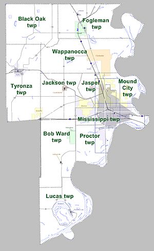
Counties in Arkansas are divided into smaller areas called townships. Here are the townships in Crittenden County:
- Black Oak
- Bob Ward (includes Anthonyville, Edmondson, and a small part of Jennette)
- Fogleman (includes Gilmore, Turrell)
- Jackson (includes Crawfordsville, part of Marion, part of West Memphis, and a small part of Jennette)
- Jasper (includes Sunset, most of Marion, part of West Memphis, and a small part of Clarkedale)
- Lucas (includes Horseshoe Lake)
- Mississippi (includes most of West Memphis, and part of Marion)
- Mound City (includes part of Marion, part of West Memphis, and a small part of Clarkedale)
- Proctor (includes part of West Memphis)
- Tyronza (includes Earle, and most of Jennette)
- Wappanocca (includes Jericho, and most of Clarkedale)
See also
 In Spanish: Condado de Crittenden (Arkansas) para niños
 | Charles R. Drew |
 | Benjamin Banneker |
 | Jane C. Wright |
 | Roger Arliner Young |


