Curtis Island (New Zealand) facts for kids

Curtis Island (left) and Cheeseman Island from north
|
|

Map
|
|
| Geography | |
|---|---|
| Coordinates | 30°32′28″S 178°33′27″W / 30.54111°S 178.55750°W |
| Archipelago | Kermadec Islands |
| Highest elevation | 47 m (154 ft) |
| Administration | |
|
New Zealand
|
|
| Demographics | |
| Population | Uninhabited |
Curtis Island is a small, uninhabited island in the southwest Pacific Ocean. It's a volcanic island that is part of the Kermadec Islands, which belong to New Zealand. This island has an active volcanic crater with steam vents, called fumaroles. Its green slopes are home to many seabirds. Over the last 200 years, the island has actually risen about 18 meters from the sea!
Contents
Island History
Who First Visited Curtis Island?
The first European to visit Curtis Island was Lieutenant John Watts in 1788. He was on the ship Lady Penrhyn. He named the island after one of his supporters, William Curtis.
What Were Castaway Depots?
In 1888, special supply stations called castaway depots were set up on Curtis and nearby Cheeseman Island. These depots held food and supplies for sailors who might get shipwrecked.
Curtis Island During World War I
During the First World War, a German commander named Felix von Luckner visited Curtis Island in 1917. He was trying to escape from New Zealand and stopped at the island to get supplies from the castaway depot.
Geography of Curtis Island
Where Is Curtis Island Located?
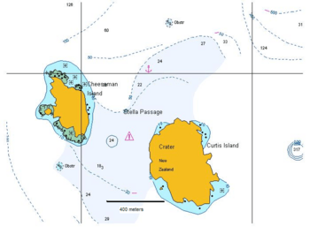
Curtis Island is part of the Kermadec Islands. These islands are located between Tonga to the north and New Zealand to the south. Other islands in this group include Raoul Island and Macauley Island, which are about 35 kilometers north of Curtis. Cheeseman Island is very close to Curtis, less than 1 kilometer away.
What Does Curtis Island Look Like?
Curtis Island is quite small, covering about 42 to 52 hectares (which is like 42 to 52 football fields). Tall Cliffs surround a flat area in the middle, which is about 100 meters high. There are no known beaches on the island. The island sits on top of a large underwater area that is less than 250 meters deep.
The Island's Volcanic Crater
In the center of Curtis Island, there's a deep, oval-shaped volcanic crater. It's about 400-450 meters deep and up to 200 meters wide. A warm stream flows from the crater into the sea. There's also a second, smaller crater on the southeastern side of the island. The highest point on Curtis Island is 47 meters above sea level.
How Curtis Island Was Formed
The Tonga-Kermadec Arc
Curtis Island is part of a long chain of volcanoes called the Tonga-Kermadec arc. This arc stretches for about 2,550 kilometers from New Zealand to Tonga. It's formed where the Pacific Plate slowly slides underneath the Australian Plate. This process, called subduction, creates magma deep underground, which then rises to form volcanoes. Most of this volcanic chain is underwater.
Volcanic Rocks of Curtis Island
Most of Curtis Island is made of pyroclastic rocks. These are rocks formed from volcanic ash and fragments that exploded from a volcano. You can find pieces of pumice and other rocks within them. The volcanic rocks on Curtis Island are mainly andesite, which is a common type of volcanic rock.
Hot Water and Minerals
Inside the crater, you can find special deposits formed by hot water, like silica and sulfur. The hot water changes the rocks, creating different minerals. These minerals include things like alunite and pyrite.
Wildlife on Curtis Island
A Special Nature Reserve
Like the other Kermadec islands, Curtis Island is a nature reserve. This means it's a protected area managed by the New Zealand Department of Conservation.
Plants and Birds
You can find various plants on the island, including ice plant, herbs, grasses, and sedges. The crater floor, however, is mostly bare.
Many seabirds make their homes on Curtis Island. Boobies, grey ternlets, and petrels all nest here. The island's soil is full of burrows from their nests! Other birds like blackbirds, starlings, and song thrushes have also been seen.
No Mammals Here
There are no known mammals living on Curtis Island. In 1887, some goats were brought to the island, but they didn't survive. The sea around the island is home to many tropical and subtropical marine animals.
Island Changes Over Time
Uncertain Eruptions
Scientists believe Curtis Island is what's left of a larger volcano. There have been reports of eruptions in the past, but many are uncertain. For example, discolored water was seen near the island in 1936, but it's not clear if it was from an eruption. Earthquakes recorded in 2009 might mean that magma is moving underground.
The Island Is Rising!
One amazing thing about Curtis Island is that it has been rising out of the sea! This is called uplift. Over the last 200 years, the island has risen about 18 meters. You can see signs of this, like barnacles (small sea creatures) that are now high above the water, and old wave-cut notches (marks made by waves) that are no longer at sea level.
Between 1929 and 1964 alone, the island rose about 7 meters. Before the uplift, a place called Macdonald Cove could be used for boats, but now it's dry land.
Hot Springs and Mud Pools
On the crater floor, you can find fumaroles (steam vents), hot springs, and bubbling mud pools. Some of these pools can reach temperatures of 100 degrees Celsius (the boiling point of water!). This activity was noticed even in the 1800s. The hot water comes from steam that is heated by the volcano and mixes with rainwater.
 | Bayard Rustin |
 | Jeannette Carter |
 | Jeremiah A. Brown |

