Càrn Mairg facts for kids
Quick facts for kids Càrn Mairg |
|
|---|---|

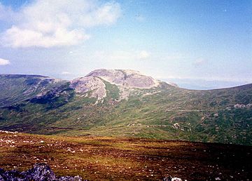
Càrn Mairg seen from Meall nan Aighean, two km to the SE.
|
|
| Highest point | |
| Elevation | 1,042 m (3,419 ft) |
| Prominence | 465 m (1,526 ft) |
| Parent peak | Schiehallion |
| Listing | Munro, Marilyn |
| Naming | |
| English translation | Hill of Sorrow / Hill of the Dead |
| Language of name | Gaelic |
| Geography | |
| Location | Perth and Kinross, Scotland |
| Parent range | Grampians |
| OS grid | NN684512 |
| Topo map | OS Landranger 51, OS Explorer 378 |

Càrn Mairg is a Scottish mountain. It is located about 18 kilometers west of Aberfeldy. This mountain stands in the Perth and Kinross area. You can find it on the northern side of Glen Lyon. Càrn Mairg is part of a group of four Munros. These mountains form a semi-circle around the Invervar Burn.
About Càrn Mairg
Càrn Mairg is often climbed with three other Munros. These are Meall Garbh, Meall nan Aighean, and Càrn Gorm. Càrn Mairg is the tallest of this group. It stands at 1041 meters (3415 feet) high. Because of its height, it is called a Munro and a Marilyn. A Munro is a Scottish mountain over 3,000 feet (914.4 m). A Marilyn is a hill with a drop of at least 150 meters on all sides.
The area around Càrn Mairg is like high, rolling moorland. There are only small dips between the four Munros. This landscape is good for ski mountaineering. Some people say it looks like the Cairngorms. Walking around all four hills is a long trip. It is almost 18 kilometers long.
Càrn Mairg is on the Chesthill Estate. This estate focuses on farming, fishing, and managing deer. In the past, there were some disagreements about access for walkers. Now, the estate has a car park for hikers at Invervar. It can hold eight cars. They ask walkers to find other places to park if it is full. This helps keep the number of people on the hills limited. The estate also suggests walking the Munros clockwise. This helps reduce disturbance to the deer.
The name Càrn Mairg comes from Gaelic. It means "Hill of Sorrow" or "Hill of the Dead." This name might remember a time when Saint Eonan stopped a serious sickness. This happened at a farm called Slatich. The nearby village of Fortingall had been greatly affected. Only one person survived there. Another idea for the name is "Pudding Hill." This comes from the word marag, meaning a meat pudding. This could describe the hill's rounded shape.
Mountain Features
Càrn Mairg is the highest point on an east-west ridge. This ridge connects to another Munro, Meall Garbh. Meall Garbh is about 3.5 kilometers to the west. This wide ridge continues east for almost 10 kilometers. It goes down into Glen Lyon near Keltneyburn village.
The ridge also has two smaller peaks. These are called "Tops" in the Munro Tables.
- Meall a’ Bhàrr is 1004 meters high. It is just over a kilometer to the west. Its top is a rocky area.
- Meall Liath (meaning Grey Hill) is 1012 meters high. It is just under a kilometer to the east. There is a dip between it and Càrn Mairg.
The top of Càrn Mairg is steep and partly rocky. It is made of greyish quartzite stones. To the southwest, the slopes drop into Coire Chearcaill. This area is drained by a stream called Allt Coire a' Chearcaill. This stream flows into the Invervar Burn. There is an old stalkers' bothy (a simple shelter) on its lower north bank.
The northern slopes go down towards Loch Rannoch and Loch Tummel. To the northeast is Gleann Mòr. This glen separates Càrn Mairg from Schiehallion. Schiehallion is about four kilometers away. All the water from Càrn Mairg flows into the River Tay. It goes either north through the River Tummel or south through the River Lyon.
How to Climb Càrn Mairg
People usually climb Càrn Mairg from Invervar. Invervar is in Glen Lyon (grid reference NN665482). This climb is often part of a circuit. This circuit includes all four Munros in the Càrn Mairg group. Parking used to be hard on the narrow road. But the new car park at Chesthill estate has made it easier.
The clockwise route follows the Invervar Burn for about one kilometer. Then you leave the forest behind. You can climb the first Munro, Càrn Gorm, by going west. The path then goes to Meall Garbh before reaching Càrn Mairg. An old line of fence posts helps with navigation along the ridge.
You can also climb Càrn Mairg directly from Fortingall (grid reference NN738470). You go up Gleann Muilinn. But this round trip is about 20 kilometers long. The summit of Càrn Mairg has a large cairn (a pile of stones). From the top, you get a great view of Schiehallion to the northeast.
 | Ernest Everett Just |
 | Mary Jackson |
 | Emmett Chappelle |
 | Marie Maynard Daly |

