Davis Hollow facts for kids
Quick facts for kids Davis Hollow |
|
|---|---|

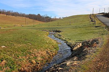
Davis Hollow looking upstream
|
|
| Physical characteristics | |
| Main source | between 860 and 880 feet (260 and 270 m) |
| River mouth | 735 ft (224 m) |
| Length | 1.4 mi (2.3 km) |
| Basin features | |
| Progression | Fishing Creek → Susquehanna River → Chesapeake Bay |
| Basin size | 0.80 sq mi (2.1 km2) |
Davis Hollow is a small stream, also called a tributary, located in Columbia County, Pennsylvania, in the United States. It flows into Fishing Creek. This stream is about 1.4 miles (2.3 km) long and runs through Benton Township. The area of land that drains water into Davis Hollow, called its watershed, is about 0.80 square miles (2.1 km2).
The ground and rocks around Davis Hollow are mostly made up of different types of soil and rock left behind by glaciers or rivers. These include alluvium (river deposits), till (glacial deposits), and bedrock.
Contents
Where Does Davis Hollow Flow?
Davis Hollow starts in a valley in Benton Township. It first flows southwest for a short distance. Then, it turns west for about half a mile, crossing a road called Pied Piper Road.
After that, the stream turns southwest again for a short distance. It leaves the valley and flows onto a flat area. It continues southwest and crosses Pennsylvania Route 487. From there, it turns south-southwest and soon joins Fishing Creek.
Davis Hollow meets Fishing Creek about 20.78 miles (33.44 km) before Fishing Creek reaches its own end.
Land and Rocks Around the Stream
The land where Davis Hollow joins Fishing Creek is about 735 feet (224 m) above sea level. Where the stream begins, its source, the elevation is higher, between 860 and 880 feet (260 and 270 m) above sea level.
Near the upper part of Davis Hollow, there are two areas of alluvium. This is a type of soil that rivers deposit, and it contains layers of silt, sand, and gravel. However, most of the ground in this area is made of solid bedrock. This bedrock is mostly sandstone and shale.
There's also a type of till called Wisconsinan Till, which is rock and soil left by glaciers. Some Wisconsinan Lag, another type of glacial deposit, is found at the top of the valley. Closer to the lower part of the stream, the ground is mainly alluvium, bedrock, and alluvial terrace (old riverbeds). There are also some Illinoian Lag and Illinoian Flow-Till deposits, which are from an older glacial period.
In the valley of Davis Hollow, the edge of the Wisconsinan glacier dropped about 240 feet (73 m) over a distance of 1,000 feet (300 m).
The Davis Hollow Watershed
The watershed of Davis Hollow covers an area of 0.80 square miles (2.1 km2). A watershed is all the land where water drains into a particular stream or river.
The mouth of Davis Hollow is located in the area shown on the United States Geological Survey map called "Benton." However, the stream's source is on the map called "Stillwater."
History of the Name
Davis Hollow was officially added to the Geographic Names Information System on August 2, 1979. This system keeps track of names for places in the United States. Its special ID number in the system is 1172989.
Davis Hollow is actually an unnamed stream that gets its name from the valley it flows through. The valley itself was probably named after a local farmer or landowner who lived there a long time ago.
According to a book from 1982 by Walter Brasch called Columbia County Place Names, some old maps show the Davis Hollow valley as being in Fishing Creek Township. Other maps show it as being near Rohrsburg.
 | Shirley Ann Jackson |
 | Garett Morgan |
 | J. Ernest Wilkins Jr. |
 | Elijah McCoy |


