Delta, Colorado facts for kids
Quick facts for kids
Delta, Colorado
|
|
|---|---|

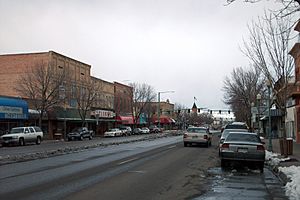
Main Street in Delta.
|
|
| Nickname(s):
City of Murals
|
|

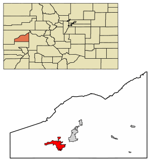
Location of the City of Delta in Delta County, Colorado.
|
|
| Country | |
| State | |
| County | Delta |
| Incorporated | October 24, 1882 |
| Government | |
| • Type | Home rule municipality |
| Area | |
| • Total | 13.530 sq mi (35.043 km2) |
| • Land | 13.273 sq mi (34.378 km2) |
| • Water | 0.257 sq mi (0.665 km2) |
| Elevation | 4,931 ft (1,503 m) |
| Population
(2020)
|
|
| • Total | 9,035 |
| • Density | 681/sq mi (263/km2) |
| Time zone | UTC−07:00 (MST) |
| • Summer (DST) | UTC−06:00 (MDT) |
| ZIP code |
81416
|
| Area code(s) | 970 |
| FIPS code | 08-19850 |
| GNIS feature ID | 2410319 |
Delta is a city in Colorado, United States. It is the main city and county seat of Delta County. In 2020, about 9,035 people lived there.
Delta is a special kind of city called a "home rule municipality." This means it has more power to make its own local laws. The city is also home to the offices for three large National Forests: Grand Mesa, Gunnison, and Uncompahgre.
Contents
History of Delta
Delta started as a place for trading. Ute people and early settlers would meet here to trade goods. A trading post called Fort Uncompahgre was built in 1828.
The city got its name because of its location. It sits on a river delta, which is where the Uncompahgre River flows into the Gunnison River. Delta officially became a city in 1882.
Geography and Location
Delta is located in the southwestern part of Delta County. The main part of the city is south of the Gunnison River and east of the Uncompahgre River.
The city also reaches north across the Gunnison River into an area called "North Delta." It stretches west about 6 miles (10 km) along U.S. Route 50 to Westwinds Airport.
In 2020, Delta covered a total area of about 13.5 square miles (35.043 square kilometers). A small part of this area, about 0.26 square miles (0.665 square kilometers), is water. Delta is part of the Colorado Western Slope region, which is the western side of the Rocky Mountains in Colorado.
Delta's Population Over Time
| Historical population | |||
|---|---|---|---|
| Census | Pop. | %± | |
| 1890 | 470 | — | |
| 1900 | 819 | 74.3% | |
| 1910 | 2,388 | 191.6% | |
| 1920 | 2,623 | 9.8% | |
| 1930 | 2,938 | 12.0% | |
| 1940 | 3,717 | 26.5% | |
| 1950 | 4,097 | 10.2% | |
| 1960 | 3,832 | −6.5% | |
| 1970 | 3,694 | −3.6% | |
| 1980 | 3,931 | 6.4% | |
| 1990 | 3,789 | −3.6% | |
| 2000 | 6,400 | 68.9% | |
| 2010 | 8,915 | 39.3% | |
| 2020 | 9,035 | 1.3% | |
| U.S. Decennial Census | |||
The city of Delta has grown a lot over the years. In 2010, there were 8,915 people living in the city. By 2020, the population had increased to 9,035 people.
Art and Culture in Delta
Fort Uncompahgre is an important historical site in Delta. It was built in 1828 by Antoine Robidoux as a place for fur trading. Today, tour guides at the fort dress in old-fashioned clothes. They show visitors how people used to live, including how they trapped beavers, made buckskins (soft leather), shaped arrowheads, and worked with metal at a forge.
Things to Do and See
Delta has several parks where you can relax and play:
- Pow Wow Arbor
- Mountain View Pavilion
- Riley Pavilion / Cleland Park
- Shade Pavilion Island
- Cottonwood Park
- Emerald Hills Park
From Delta, you can see the Grand Mesa Mountain range. It is known as the largest flat-topped mountain in the world!
Local News and Media
The main newspaper in Delta is the Delta County Independent. It comes out every Wednesday. Another popular local paper is The High Country Shopper, which is free and shares news and ads across the county.
Transportation in Delta
Air and Train Travel
The closest airport with regular flights is Montrose Regional Airport. It is about 21 miles (34 km) south of Delta. For train travel, you can go to Grand Junction, which is about 39 miles (63 km) north. There, you can catch the Amtrak California Zephyr train. Delta is also part of Colorado's Bustang bus system, with a route connecting Durango and Grand Junction.
Major Highways Connecting Delta
 U.S. Highway 50 is a major road that runs east to west across 12 states. In Colorado, it goes through Delta as Main Street. This highway connects Delta to other cities like Montrose, Grand Junction, and Pueblo.
 State Highway 65 is about 61 miles (98 km) long. It goes north from State Highway 92 (east of Delta), crosses over the Grand Mesa, and ends near Palisade at Interstate 70.
 State Highway 92 starts in Delta at the corner of Main Street and First Street. It runs east for about 73 miles (117 km). This highway eventually meets U.S. Highway 50 again near Blue Mesa Reservoir and Curecanti National Recreation Area.
Education in Delta
Delta is part of the Delta County School District. This school district also includes nearby towns like Cedaredge, Crawford, Hotchkiss, and Paonia. In the 2020-2021 school year, about 4,792 students attended schools in this district.
Delta is also home to Technical College of the Rockies. This is a smaller school that teaches job skills and trades to about 300 students each year.
Famous People from Delta
- Chuck Cottier, a baseball player and manager
- Dale Ishimoto, an American actor
- Frank H. Ono, who received the Medal of Honor
- Matt Soper, a Colorado Representative in the state's House District 54
- Felix L. Sparks, a judge on the Colorado Supreme Court and a U.S. Army colonel
Images for kids
See also
 In Spanish: Delta (Colorado) para niños
 | Mary Eliza Mahoney |
 | Susie King Taylor |
 | Ida Gray |
 | Eliza Ann Grier |


