Devils River (Wisconsin) facts for kids
Quick facts for kids Devils River |
|
|---|---|
| Country | United States |
| Physical characteristics | |
| Main source | 6 miles (9.7 km) west of Denmark, Wisconsin |
| River mouth | West Twin River at the north end of Richard J. Drum Memorial Forest 650 feet (200 m) |
| Length | 15.8 miles (25.4 km) |
| Basin features | |
| Progression | East-southeast |
| River system | West Twin River |
| Basin size | 176 square miles (460 km2) |
The Devils River is a small river in Wisconsin, United States. It's about 15.8-mile-long (25.4 km). The river flows through Brown and Manitowoc counties. It joins with the Neshota River to form the West Twin River. The river is part of a larger water system called the West Twin River watershed.
The Ojibwe people had a special name for the river: Ma-na-to-kik-e-we-se-be. This means "Stooping Spirit River." Early European settlers often misunderstood the word Ma-na-to (or manitou). They thought it meant "devil," which is how the river got its name today.
Contents
The River's Path and Wildlife
The Devils River flows through mostly agricultural land. The land slopes gently downwards. Near where it meets another river, there are three sets of rapids.
The upper part of the river, about 8 miles (13 km) long, has less water flow. Its natural environment is not as healthy. In late summer and fall, when it's dry, much of the upper two-thirds of the river dries up. Only separate pools of water remain.
Fish and Other Creatures
You can only fish for sport in the lower third of the river. Small fish called minnows are common throughout the river. These include the western blacknose dace, common creek chub, and common shiner. You might also find longnose dace, northern redbelly dace, and redside dace. Other fish like the white sucker and different types of darter live here too.
Sport fish like black bullhead catfish and rock bass naturally live in the lower part of the river. The Wisconsin Department of Natural Resources adds fish like brown trout, northern pike, and rainbow trout to the river. However, these fish often do not survive the winter. An invasive species called the rusty crayfish has also been found in the Devils River.
The River's Water System
The Devils River is part of the West Twin River watershed. A watershed is an area of land where all the water drains into a single river or lake. The West Twin River watershed is one of seven watersheds that flow into the Twin-Door-Kewaunee River Basin. This basin then empties into Lake Michigan.
History of the Devils River Area
Long ago, Native Americans used a major trail that crossed the Devils River. This crossing was near Cherney Maribel Caves County Park in Manitowoc County. Later, white settlers used this same trail to travel across the country. In 1840, a U.S. Army Captain named Thomas J. Cram surveyed the area. He suggested building a military road from Fort Dearborn (now Chicago) to Fort Howard (now Green Bay, Wisconsin).
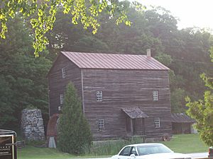
In 1847, an investor named Pliney Pierce built Rock Mill on the Devils River. This mill is now listed on the National Register of Historic Places. It is one of the oldest buildings in Manitowoc County.
Building a Water Pipeline
In 2005, the Central Brown County Water Authority planned to build a 65-mile-long (105 km) water pipeline. This pipeline was needed because growing towns had used up much of their water. Also, the remaining water was polluted. The original plan involved removing old stone bridge parts from the military road. They also planned to dig a trench across the riverbed for the pipeline. Digging tunnels was too expensive.
However, the Water Authority changed the pipeline's path. This way, they could avoid damaging the historic stone bridge parts. The pipeline was built in 2006. This $80 million pipeline started working in August 2007.
Fun Activities on the Devils River
You can visit the Devils River Campground, which is located near Richard J. Drum Memorial Forest.
A 14-mile (23 km) long trail called the Devils River State Recreational Trail is being built. This trail runs alongside the river. It will let people hike and easily reach the river. The trail will take hikers near the Devils River Crossing. This is a famous spot where railroad trestle bridges stand 100 feet (30 m) high above the river.
 | Toni Morrison |
 | Barack Obama |
 | Martin Luther King Jr. |
 | Ralph Bunche |


