Dodge County, Georgia facts for kids
Quick facts for kids
Dodge County
|
|
|---|---|

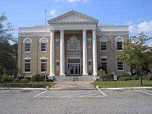
Dodge County Courthouse in Eastman
|
|

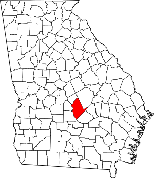
Location within the U.S. state of Georgia
|
|
 Georgia's location within the U.S. |
|
| Country | |
| State | |
| Founded | 1870 |
| Named for | William E. Dodge |
| Seat | Eastman |
| Largest city | Eastman |
| Area | |
| • Total | 503 sq mi (1,300 km2) |
| • Land | 496 sq mi (1,280 km2) |
| • Water | 7.2 sq mi (19 km2) 1.4%% |
| Population
(2020)
|
|
| • Total | 19,925 |
| • Density | 40/sq mi (20/km2) |
| Time zone | UTC−5 (Eastern) |
| • Summer (DST) | UTC−4 (EDT) |
| Congressional district | 8th |
Dodge County is a county in the central part of Georgia, USA. In 2020, about 19,925 people lived here. The main town, or county seat, is Eastman. Dodge County is part of a historic area in the South. Long ago, this region was known for growing a lot of cotton. It has many old buildings and a large African-American community. This helps show the unique culture of the South.
Contents
History of Dodge County
Before 1802, the land that is now Dodge County belonged to the Creek Indians. Between 1802 and 1805, treaties were signed. These treaties meant that all the land east of the Ocmulgee River was given by the Creek Indians.
This land was then given out to Georgia citizens through a special lottery. In 1803, Wilkinson County was created from this land. Later, Telfair and Laurens counties were formed from Wilkinson County. In 1808, Pulaski County was created from Laurens County.
How Dodge County Was Formed
In 1869, a new railroad called the Macon and Brunswick Railroad was built. New towns started to grow along this railroad line. The area was quite far from the county seat at the time, which was Hawkinsville. Because of this, people decided it would be a good idea to create a new county. They wanted the main town of this new county to be right on the railroad line.
Dodge County was officially created on October 26, 1870. This happened during the Reconstruction era, a time after the American Civil War when the Southern states were being rebuilt. The county was named after William E. Dodge. He was a businessman who helped build the county courthouse. This courthouse was used until 1908 and stood in the same spot where the current courthouse is today.
Geography and Rivers
Dodge County covers a total area of about 503 square miles. Most of this is land (496 square miles), and a small part (7.2 square miles) is water.
Rivers and Waterways
The western part of Dodge County, near Eastman, is in the Lower Ocmulgee River area. This river flows into the larger Altamaha River. The eastern part of the county is in the Little Ocmulgee River area, which also flows into the Altamaha River. A small northern section of the county is in the Lower Oconee River area, another part of the Altamaha River basin.
These rivers were very important long ago. They were used for trade, helping to move goods like cotton and timber downriver to markets.
Neighboring Counties
Dodge County shares borders with these other counties:
- Laurens County - to the northeast
- Wheeler County - to the east
- Telfair County - to the southeast
- Wilcox County - to the west
- Pulaski County - to the west
- Bleckley County - to the northwest
Communities in Dodge County
Dodge County has several towns and communities.
Cities
Towns
Unincorporated Communities
These are smaller communities that are not officially part of a city or town:
Population and People
The population of Dodge County has changed over the years. Here's a look at how many people have lived here:
| Historical population | |||
|---|---|---|---|
| Census | Pop. | %± | |
| 1880 | 5,358 | — | |
| 1890 | 11,452 | 113.7% | |
| 1900 | 13,975 | 22.0% | |
| 1910 | 20,127 | 44.0% | |
| 1920 | 22,540 | 12.0% | |
| 1930 | 21,599 | −4.2% | |
| 1940 | 21,022 | −2.7% | |
| 1950 | 17,865 | −15.0% | |
| 1960 | 16,483 | −7.7% | |
| 1970 | 15,658 | −5.0% | |
| 1980 | 16,955 | 8.3% | |
| 1990 | 17,607 | 3.8% | |
| 2000 | 19,171 | 8.9% | |
| 2010 | 21,796 | 13.7% | |
| 2020 | 19,925 | −8.6% | |
| 2023 (est.) | 19,776 | −9.3% | |
| U.S. Decennial Census 1790-1880 1890-1910 1920-1930 1930-1940 1940-1950 1960-1980 1980-2000 2010 |
|||
People in 2020
In 2020, there were 19,925 people living in Dodge County. These people lived in 7,628 households, with 5,167 families.
Here's a breakdown of the different groups of people living in Dodge County in 2020:
| Race | Number of People | Percentage |
|---|---|---|
| White (not Hispanic) | 12,865 | 64.57% |
| Black or African American (not Hispanic) | 5,847 | 29.35% |
| Native American | 21 | 0.11% |
| Asian | 95 | 0.48% |
| Pacific Islander | 8 | 0.04% |
| Other/Mixed | 469 | 2.35% |
| Hispanic or Latino | 620 | 3.11% |
Transportation
Dodge County has several important roads and an airport.
Major Highways
Many highways run through Dodge County, connecting it to other parts of Georgia.
 US 23
US 23 US 280
 US 319
 US 341
 US 341 Bus.
 US 441
 SR 27
SR 27 SR 27 Bus.
 SR 30
SR 30 SR 31
SR 31 SR 46
SR 46 SR 46 Conn.
 SR 87
SR 87 SR 117
 SR 126
 SR 165
 SR 230
 SR 257
Heart of Georgia Regional Airport
The Heart of Georgia Regional Airport is located about three miles east of Eastman. It is near State Route 46. The airport is 304 feet above sea level. It has a long runway (6,506 feet by 100 feet) that can handle many types of planes.
The airport is owned by the Heart of Georgia Regional Airport Authority. It is also home to the Middle Georgia State College Georgia Aviation campus. This campus teaches students about aviation. They even operate a student control tower that is ranked number one in the United States by the Federal Aviation Administration.
Other businesses at the airport include companies that make aircraft parts, finish metal for planes, and do general metal work. The main building at the airport is named after W. S. Stuckey Sr.. He was from Eastman and started Stuckey's Candy Company. He was also a pioneer in aviation.
Education
For more details about schools in the area, you can visit the main article about Education in Eastman, Georgia.
See also
 In Spanish: Condado de Dodge (Georgia) para niños

