Dorchester, New Hampshire facts for kids
Quick facts for kids
Dorchester, New Hampshire
|
||
|---|---|---|
|
Town
|
||

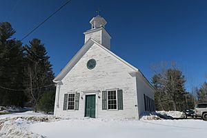
Dorchester Community Church
|
||
|
||

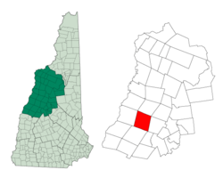
Location in Grafton County, New Hampshire
|
||
| Country | United States | |
| State | New Hampshire | |
| County | Grafton | |
| Incorporated | 1772 | |
| Villages | Dorchester Bucks Corner Cheever North Dorchester |
|
| Area | ||
| • Total | 45.2 sq mi (117.1 km2) | |
| • Land | 44.6 sq mi (115.5 km2) | |
| • Water | 0.6 sq mi (1.6 km2) 1.34% | |
| Elevation | 1,391 ft (424 m) | |
| Population
(2020)
|
||
| • Total | 339 | |
| • Density | 8/sq mi (2.9/km2) | |
| Time zone | UTC−5 (Eastern) | |
| • Summer (DST) | UTC−4 (Eastern) | |
| ZIP Code |
03266
|
|
| Area code(s) | 603 | |
| FIPS code | 33-18740 | |
| GNIS feature ID | 0873579 | |
Dorchester is a small town in Grafton County, New Hampshire, in the United States. In 2020, about 339 people lived there.
Contents
History of Dorchester
Dorchester was first given permission to be a town in 1761. This was done by Governor Benning Wentworth. It was named after a place called Dorchester in England.
However, the first people who were given the land did not settle there. So, it was given out again in 1766, but still no one settled.
Finally, Governor John Wentworth gave the land to 72 new people on May 1, 1772. Soon after, people started to move in. The very first settlers were Benjamin Rice and Stephen Murch. They came from Hanover, but were originally from Connecticut.
The first time a count of the people (called a census) was done in Dorchester was in 1790. At that time, 175 people lived there. By 1859, the town had grown to 711 people. There were also many sawmills, which cut wood into planks. There were also mills that made clapboard (for house siding) and shingles (for roofs). People also made charcoal in Dorchester.
Geography of Dorchester
Dorchester covers a total area of about 117.1 square kilometers (about 45.2 square miles). Most of this is land, with a small part being water.
The town has several rivers flowing through it. The South Branch Baker River flows north, and the Mascoma River flows south. The Indian River is a smaller river that joins the Mascoma River. There are also two ponds, Cummins Pond and Reservoir Pond, in the western part of town.
The water in the northeastern part of Dorchester flows into the Merrimack River. The water in the southwestern part flows into the Connecticut River. This means Dorchester is part of two different "watersheds," which are areas where all the water drains into a common river system.
The highest point in Dorchester is on its western border. This spot is about 1,391 feet (424 meters) above sea level. It is just east of a mountain called Smarts Mountain.
New Hampshire Route 118 is a main road that goes through the town.
People in Dorchester
| Historical population | |||
|---|---|---|---|
| Census | Pop. | %± | |
| 1790 | 175 | — | |
| 1800 | 349 | 99.4% | |
| 1810 | 537 | 53.9% | |
| 1820 | 584 | 8.8% | |
| 1830 | 702 | 20.2% | |
| 1840 | 769 | 9.5% | |
| 1850 | 711 | −7.5% | |
| 1860 | 691 | −2.8% | |
| 1870 | 689 | −0.3% | |
| 1880 | 585 | −15.1% | |
| 1890 | 370 | −36.8% | |
| 1900 | 308 | −16.8% | |
| 1910 | 241 | −21.8% | |
| 1920 | 228 | −5.4% | |
| 1930 | 115 | −49.6% | |
| 1940 | 144 | 25.2% | |
| 1950 | 133 | −7.6% | |
| 1960 | 91 | −31.6% | |
| 1970 | 141 | 54.9% | |
| 1980 | 244 | 73.0% | |
| 1990 | 392 | 60.7% | |
| 2000 | 353 | −9.9% | |
| 2010 | 355 | 0.6% | |
| 2020 | 339 | −4.5% | |
| U.S. Decennial Census | |||
In the year 2000, there were 353 people living in Dorchester. These people lived in 132 homes. About 99 of these were families.
The town had about 7.9 people per square mile. This means it is not a very crowded place. Most of the people living in Dorchester were White (97.17%).
About 35.6% of the homes had children under 18 living there. Most homes (59.8%) were married couples. The average home had about 2.67 people.
The age of people in Dorchester varied. About 27.5% were under 18 years old. About 11.9% were 65 years or older. The average age was 40 years old.
Famous People from Dorchester
- Rufus Blodgett (1834–1910), a US senator who represented New Jersey.
- Albert Woodworth (1843–1908), a businessman and state legislator.
See also
 In Spanish: Dorchester (Nuevo Hampshire) para niños


