
Dragon Head (Arizona) facts for kids
Quick facts for kids Dragon Head |
|
|---|---|
.jpg)
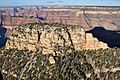
east aspect, aerial photo
(note: the flat-topped shadow) |
|
| Highest point | |
| Elevation | 7,765 ft (2,367 m) |
| Prominence | 1,351 ft (412 m) |
| Parent peak | The Dragon (Arizona) |
| Geography | |

Dragon.Head
Location in Arizona

Dragon.Head
Location in the United States
|
|
| Location | Grand Canyon Coconino County, Arizona, US |
| Parent range | Kaibab Plateau Colorado Plateau |
| Topo map | USGS Shiva Temple |
| Geology | |
| Age of rock | Permian down to Cambrian |
| Mountain type | sedimentary rock: limestone, sandstone, shale, mudstone, siltstone |
| Type of rock | prominence-Kaibab Limestone on slopes of Toroweap Formation, on platform of Coconino Sandstone-(note: flat-topped shadow) and Toroweap Formation-(debris), Coconino Sandstone-(platform) Hermit Shale, Supai Group-(4 units), Redwall Limestone-(cliff), Tonto Group-(3 units) 3_Muav Limestone-(short platform/cliff), 2_Bright Angel Shale-(forested/vegetated) |
Dragon Head (Arizona) is a mountain peak in the amazing Grand Canyon. It stands tall at about 7,765 feet (2,367 meters) above sea level. You can find it in Coconino County, in the state of Arizona, USA.
This cool peak is located north of an area called the Hindu Amphitheater. It's about 2 miles west of Shiva Temple. It's also about 2.5 miles southeast of Grama Point. Unlike Shiva Temple, which has a big forest, Dragon Head has a smaller, flatter top. This flat top is only about 5 acres in size.
What is Dragon Head Made Of?
Dragon Head is like a giant layer cake made of different kinds of rock. The very top, flat part of Dragon Head is made from a hard rock called Kaibab Limestone. This rock is very strong, which is why it forms a flat platform. When this rock wears away, it leaves behind a lot of rocky bits.
Below the Kaibab Limestone, you'll find slopes made of a rock layer called the Toroweap Formation. Underneath that is a shorter cliff of Coconino Sandstone. This sandstone also forms a flat ridge that stretches north. Below the sandstone, there are slopes of Hermit Shale.
Even further down, there are four more layers of rock called the Supai Group. These layers are often a beautiful deep orange-red color. Some of these layers form cliffs, while others create gentle slopes as they wear away.
Forests and Plants
Because Dragon Head is located closer to the North Rim of the Grand Canyon, it's in an area that gets enough rain for trees to grow. The flat top of Dragon Head has some trees, but not as many as other parts of the Grand Canyon.
The slopes of the Toroweap Formation, which are below the top layer, have more trees. Even some of the cliffs on Dragon Head have plants growing on them. This is especially true for the Kaibab Limestone layer, where cracks in the rock allow plants to take root.

Images for kids
-
east aspect, aerial photo
(note: the flat-topped shadow)
