Drew County, Arkansas facts for kids
Quick facts for kids
Drew County
|
|
|---|---|

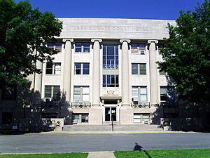
Drew County Courthouse in Monticello
|
|

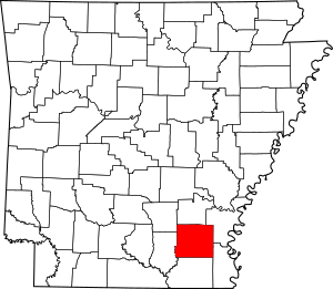
Location within the U.S. state of Arkansas
|
|
 Arkansas's location within the U.S. |
|
| Country | |
| State | |
| Founded | November 26, 1846 |
| Named for | Thomas Drew |
| Seat | Monticello |
| Largest city | Monticello |
| Area | |
| • Total | 836 sq mi (2,170 km2) |
| • Land | 828 sq mi (2,140 km2) |
| • Water | 7.3 sq mi (19 km2) 0.9%% |
| Population
(2020)
|
|
| • Total | 17,350 |
| • Estimate
(2023)
|
16,945 |
| • Density | 20.754/sq mi (8.013/km2) |
| Time zone | UTC−6 (Central) |
| • Summer (DST) | UTC−5 (CDT) |
| Congressional district | 4th |
Drew County is a county located in the southeastern part of Arkansas. In 2020, about 17,350 people lived here. The main city and county seat is Monticello. Drew County was created on November 26, 1846. It was named after Thomas Drew, who was the third governor of Arkansas.
Contents
History of Drew County
Drew County is located where the Arkansas Delta meets the Arkansas Timberlands. The rich soil in the lowlands helped early settlers. They grew a lot of cotton, which was a very important crop. This work was done by enslaved African Americans. They also grew corn, apples, peaches, and tomatoes.
After the Civil War, some parts of Drew County changed. For example, Mill Creek Township became part of the new Lincoln County in 1871.
Later, in the late 1800s and early 1900s, cutting down trees for timber became more important than cotton. The number of people living in the county went down from 1910 to 1970. This was partly because fewer workers were needed in the timber industry. Also, many African Americans moved away. They joined the Great Migration to cities in the north and midwest. They were looking for better opportunities and to escape unfair laws. After World War II, even more people moved to the West Coast.
Over time, different types of businesses came to Drew County. Several colleges were started here in the early 1900s. One of these colleges grew into the University of Arkansas at Monticello. Today, Drew County has many different types of businesses. It is an important economic center in southeast Arkansas.
Geography of Drew County
Drew County covers about 836 square miles. Most of this area, about 828 square miles, is land. The rest, about 7.3 square miles, is water.
There is a swamp in Drew County called Loggy Bayou. It is not the same as a bayou with the same name in Louisiana.
Main Roads
 Future Interstate 69
 U.S. Highway 65
 U.S. Highway 165
 U.S. Highway 278
 U.S. Highway 425
 Highway 530
 Highway 4
 Highway 8
 Highway 35
 Highway 133
Neighboring Counties
- Lincoln County (north)
- Desha County (northeast)
- Chicot County (southeast)
- Ashley County (south)
- Bradley County (west)
- Cleveland County (northwest)
People in Drew County
| Historical population | |||
|---|---|---|---|
| Census | Pop. | %± | |
| 1850 | 3,276 | — | |
| 1860 | 9,078 | 177.1% | |
| 1870 | 9,960 | 9.7% | |
| 1880 | 12,231 | 22.8% | |
| 1890 | 17,352 | 41.9% | |
| 1900 | 19,451 | 12.1% | |
| 1910 | 21,960 | 12.9% | |
| 1920 | 21,822 | −0.6% | |
| 1930 | 19,928 | −8.7% | |
| 1940 | 19,831 | −0.5% | |
| 1950 | 17,959 | −9.4% | |
| 1960 | 15,213 | −15.3% | |
| 1970 | 15,157 | −0.4% | |
| 1980 | 17,910 | 18.2% | |
| 1990 | 17,369 | −3.0% | |
| 2000 | 18,723 | 7.8% | |
| 2010 | 18,509 | −1.1% | |
| 2020 | 17,350 | −6.3% | |
| 2023 (est.) | 16,945 | −8.4% | |
| U.S. Decennial Census 1790–1960 1900–1990 1990–2000 2010 |
|||
2020 Census Information
| Race | Num. | Perc. |
|---|---|---|
| White (non-Hispanic) | 11,148 | 64.25% |
| Black or African American (non-Hispanic) | 4,815 | 27.75% |
| Native American | 68 | 0.39% |
| Asian | 100 | 0.58% |
| Pacific Islander | 9 | 0.05% |
| Other/Mixed | 554 | 3.19% |
| Hispanic or Latino | 656 | 3.78% |
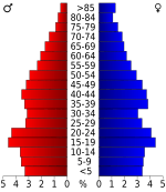
In 2020, there were 17,350 people living in Drew County. There were 7,157 households and 4,651 families.
Communities in Drew County
Cities
- Monticello (the county seat)
- Tillar (partly in Desha County)
- Wilmar
Towns
Townships
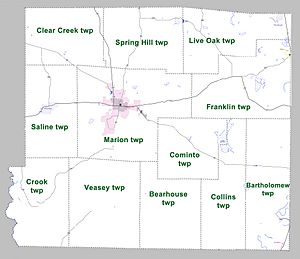
Townships in Arkansas are the divisions of a county. Each township includes unincorporated areas; some may have incorporated cities or towns within part of their boundaries. Arkansas townships have limited purposes in modern times. However, the United States Census does list Arkansas population based on townships (sometimes referred to as "county subdivisions" or "minor civil divisions"). Townships are also of value for historical purposes in terms of genealogical research. Each town or city is within one or more townships in an Arkansas county based on census maps and publications. The townships of Drew County are listed below; listed in parentheses are the cities, towns, and/or census-designated places that are fully or partially inside the township.
- Bartholomew (includes Jerome)
- Bearhouse
- Clear Creek
- Collins
- Cominto
- Crook
- Franklin (includes part of Tillar)
- Live Oak (includes Winchester)
- Marion (includes Monticello)
- Saline (includes Wilmar)
- Spring Hill
- Veasey
Census-designated places
- Collins
- Lacey
Other Small Communities
See also
 In Spanish: Condado de Drew para niños
 | Shirley Ann Jackson |
 | Garett Morgan |
 | J. Ernest Wilkins Jr. |
 | Elijah McCoy |


